
Size of this preview:
800 × 456 pixels. Other resolutions:
320 × 182 pixels |
640 × 365 pixels |
1,024 × 584 pixels |
1,280 × 729 pixels |
2,560 × 1,459 pixels |
3,729 × 2,125 pixels.
Original file (3,729 × 2,125 pixels, file size: 1.38 MB, MIME type: image/png)
| This is a file from the
Wikimedia Commons. Information from its
description page there is shown below. Commons is a freely licensed media file repository. You can help. |
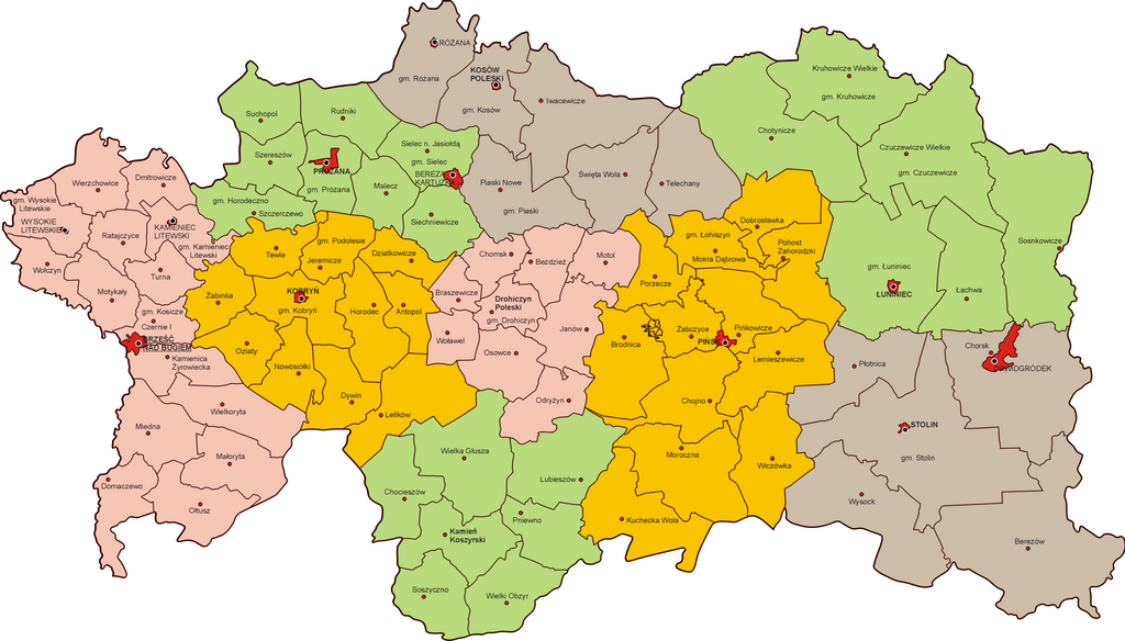
| Description | Podział administracyjny województwa poleskiego w 1939 r. |
| Date | |
| Source | własna praca na podstawie Mapa Gmin Rzeczypospolitej Polskiej, GUS 1938 |
| Author | Poznaniak |
| Permission ( Reusing this file) |
This file is licensed under the
Creative Commons
Attribution-Share Alike 2.5 Generic license.
|
File history
Click on a date/time to view the file as it appeared at that time.
| Date/Time | Thumbnail | Dimensions | User | Comment | |
|---|---|---|---|---|---|
| current | 11:20, 14 July 2013 |
| 3,729 × 2,125 (1.38 MB) | Poznaniak | popr. |
| 16:47, 14 November 2010 |
 | 3,730 × 2,126 (831 KB) | Poznaniak | {{Information |Description=Podział administracyjny województwa poleskiego w 1939 r. |Source=własna praca |Date=14.11.2010 |Author= Poznaniak |Permission={{cc-by-sa-2.5}} }} Category:Maps of Poland |
File usage
The following pages on the English Wikipedia use this file (pages on other projects are not listed):
Global file usage
The following other wikis use this file:
- Usage on de.wikipedia.org
- Usage on hu.wikipedia.org
- Usage on it.wikipedia.org
- Usage on lt.wikipedia.org
- Usage on pl.wikipedia.org
- Usage on ru.wikipedia.org
- Usage on uk.wikipedia.org
- Usage on vi.wikipedia.org
Metadata
Size of this preview:
800 × 456 pixels. Other resolutions:
320 × 182 pixels |
640 × 365 pixels |
1,024 × 584 pixels |
1,280 × 729 pixels |
2,560 × 1,459 pixels |
3,729 × 2,125 pixels.
Original file (3,729 × 2,125 pixels, file size: 1.38 MB, MIME type: image/png)
| This is a file from the
Wikimedia Commons. Information from its
description page there is shown below. Commons is a freely licensed media file repository. You can help. |
| Description | Podział administracyjny województwa poleskiego w 1939 r. |
| Date | |
| Source | własna praca na podstawie Mapa Gmin Rzeczypospolitej Polskiej, GUS 1938 |
| Author | Poznaniak |
| Permission ( Reusing this file) |
This file is licensed under the
Creative Commons
Attribution-Share Alike 2.5 Generic license.
|
File history
Click on a date/time to view the file as it appeared at that time.
| Date/Time | Thumbnail | Dimensions | User | Comment | |
|---|---|---|---|---|---|
| current | 11:20, 14 July 2013 |
| 3,729 × 2,125 (1.38 MB) | Poznaniak | popr. |
| 16:47, 14 November 2010 |
| 3,730 × 2,126 (831 KB) | Poznaniak | {{Information |Description=Podział administracyjny województwa poleskiego w 1939 r. |Source=własna praca |Date=14.11.2010 |Author= Poznaniak |Permission={{cc-by-sa-2.5}} }} Category:Maps of Poland |
File usage
The following pages on the English Wikipedia use this file (pages on other projects are not listed):
Global file usage
The following other wikis use this file:
- Usage on de.wikipedia.org
- Usage on hu.wikipedia.org
- Usage on it.wikipedia.org
- Usage on lt.wikipedia.org
- Usage on pl.wikipedia.org
- Usage on ru.wikipedia.org
- Usage on uk.wikipedia.org
- Usage on vi.wikipedia.org