Photos • Location


Size of this preview:
800 × 450 pixels. Other resolutions:
320 × 180 pixels |
640 × 360 pixels |
1,024 × 576 pixels |
1,280 × 720 pixels |
2,560 × 1,441 pixels |
5,280 × 2,972 pixels.
Original file (5,280 × 2,972 pixels, file size: 1.73 MB, MIME type: image/jpeg)
| This is a file from the
Wikimedia Commons. Information from its
description page there is shown below. Commons is a freely licensed media file repository. You can help. |
.jpg)
Summary
| Description |
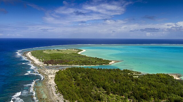
English: Wilkes Island, one of three islands that make up Wake Atoll, is home to a bird sanctuary of approximately 40,000 birds and 12 species. The U.S. Air Force, through partnerships with agencies such as the U.S. Fish and Wildlife Service and the National Oceanic and Atmospheric Administration, have worked in recent years to restore Wake Atoll to a more natural habit for its bird population and rid the three islands of invasive plant species. Wake Atoll, made up of the tropical islands of Wilkes, Wake and Peale, is located approximately 2,138 nautical miles west of Honolulu, has a population of roughly 100 residents including Air Force personnel and American and Thai contractors, and is managed by the Pacific Air Forces Regional Support Center under 11th Air Force at Joint Base Elmendorf-Richardson, Alaska. |
| Date | |
| Source | https://www.jber.jb.mil/News/Photos/igphoto/2001738259/ ; VIRIN: 170410-F-BX031-0018 |
| Author | Capt. Anastasia Schmidt |
| Camera location | | View this and other nearby images on: OpenStreetMap |
|
|---|
.jpg¶ms=019.293366_N_0166.609958_E_globe:Earth_type:camera_heading:315.00&language=en)
The
geographical information in this file was retrospectively estimated.
The location may therefore be somewhat imprecise. Verifying and refining these coordinates is strongly encouraged. |
Licensing
This image or file is a work of a
U.S. Air Force Airman or employee, taken or made as part of that person's official duties. As a
work of the
U.S. federal government, the image or file is in the
public domain in the United States.
|
 |
File history
Click on a date/time to view the file as it appeared at that time.
| Date/Time | Thumbnail | Dimensions | User | Comment | |
|---|---|---|---|---|---|
| current | 16:47, 26 October 2023 |
| 5,280 × 2,972 (1.73 MB) | Tcr25 | Uploaded a work by Capt. Anastasia Schmidt from https://www.jber.jb.mil/News/Photos/igphoto/2001738259/ with UploadWizard |
File usage
The following pages on the English Wikipedia use this file (pages on other projects are not listed):
- Battle of Wake Island
- Hurricane Ioke
- Japanese destroyer Aoi (1920)
- Japanese destroyer Hagi (1920)
- Japanese destroyer Hayate (1925)
- Japanese destroyer Kisaragi (1925)
- Japanese submarine Ro-60
- Japanese submarine Ro-66
- KEAD
- Libelle (barque)
- Peale Island
- SS Suremico
- Shigematsu Sakaibara
- Suwa Maru
- Takasago Maru
- Typhoon Olive (1952)
- Wake Island
- Wake Island (film)
- Wake Island Airfield
- Wake Island Conference
- Wake Island Device
- Wake Island Time Zone
- Wake Island rail
- Wilkes Island
- Winfield S. Cunningham
- Template:Wake
Global file usage
The following other wikis use this file:
- Usage on ceb.wikipedia.org
- Usage on www.wikidata.org
.jpg)
Size of this preview:
800 × 450 pixels. Other resolutions:
320 × 180 pixels |
640 × 360 pixels |
1,024 × 576 pixels |
1,280 × 720 pixels |
2,560 × 1,441 pixels |
5,280 × 2,972 pixels.
Original file (5,280 × 2,972 pixels, file size: 1.73 MB, MIME type: image/jpeg)
| This is a file from the
Wikimedia Commons. Information from its
description page there is shown below. Commons is a freely licensed media file repository. You can help. |
Summary
| Description |
English: Wilkes Island, one of three islands that make up Wake Atoll, is home to a bird sanctuary of approximately 40,000 birds and 12 species. The U.S. Air Force, through partnerships with agencies such as the U.S. Fish and Wildlife Service and the National Oceanic and Atmospheric Administration, have worked in recent years to restore Wake Atoll to a more natural habit for its bird population and rid the three islands of invasive plant species. Wake Atoll, made up of the tropical islands of Wilkes, Wake and Peale, is located approximately 2,138 nautical miles west of Honolulu, has a population of roughly 100 residents including Air Force personnel and American and Thai contractors, and is managed by the Pacific Air Forces Regional Support Center under 11th Air Force at Joint Base Elmendorf-Richardson, Alaska. |
| Date | |
| Source | https://www.jber.jb.mil/News/Photos/igphoto/2001738259/ ; VIRIN: 170410-F-BX031-0018 |
| Author | Capt. Anastasia Schmidt |
| Camera location | | View this and other nearby images on: OpenStreetMap |
|
|---|
The
geographical information in this file was retrospectively estimated.
The location may therefore be somewhat imprecise. Verifying and refining these coordinates is strongly encouraged. |
Licensing
This image or file is a work of a
U.S. Air Force Airman or employee, taken or made as part of that person's official duties. As a
work of the
U.S. federal government, the image or file is in the
public domain in the United States.
|
|
File history
Click on a date/time to view the file as it appeared at that time.
| Date/Time | Thumbnail | Dimensions | User | Comment | |
|---|---|---|---|---|---|
| current | 16:47, 26 October 2023 |
| 5,280 × 2,972 (1.73 MB) | Tcr25 | Uploaded a work by Capt. Anastasia Schmidt from https://www.jber.jb.mil/News/Photos/igphoto/2001738259/ with UploadWizard |
File usage
The following pages on the English Wikipedia use this file (pages on other projects are not listed):
- Battle of Wake Island
- Hurricane Ioke
- Japanese destroyer Aoi (1920)
- Japanese destroyer Hagi (1920)
- Japanese destroyer Hayate (1925)
- Japanese destroyer Kisaragi (1925)
- Japanese submarine Ro-60
- Japanese submarine Ro-66
- KEAD
- Libelle (barque)
- Peale Island
- SS Suremico
- Shigematsu Sakaibara
- Suwa Maru
- Takasago Maru
- Typhoon Olive (1952)
- Wake Island
- Wake Island (film)
- Wake Island Airfield
- Wake Island Conference
- Wake Island Device
- Wake Island Time Zone
- Wake Island rail
- Wilkes Island
- Winfield S. Cunningham
- Template:Wake
Global file usage
The following other wikis use this file:
- Usage on ceb.wikipedia.org
- Usage on www.wikidata.org