
Size of this PNG preview of this SVG file:
677 × 600 pixels. Other resolutions:
271 × 240 pixels |
542 × 480 pixels |
867 × 768 pixels |
1,156 × 1,024 pixels |
2,312 × 2,048 pixels |
1,472 × 1,304 pixels.
Original file (SVG file, nominally 1,472 × 1,304 pixels, file size: 159 KB)
| This is a file from the
Wikimedia Commons. Information from its
description page there is shown below. Commons is a freely licensed media file repository. You can help. |
Summary
| Description |
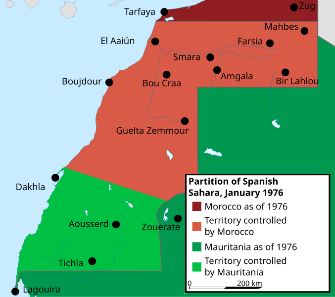
English: Partition of Spanish Sahara by Mauritania and Morocco, January 1976
Français : Partage du Sahara espagnol entre le Maroc et la Mauritanie, janvier 1976 |
| Date | |
| Source | Translation of Western Sahara situation January 1976.svg |
| Author | Original: Le Petit Chat, translation: Koavf |
| Other versions |
|
| SVG development |

Licensing
I, the copyright holder of this work, hereby publish it under the following license:
This file is licensed under the
Creative Commons
Attribution-Share Alike 4.0 International license.
- You are free:
- to share – to copy, distribute and transmit the work
- to remix – to adapt the work
- Under the following conditions:
- attribution – You must give appropriate credit, provide a link to the license, and indicate if changes were made. You may do so in any reasonable manner, but not in any way that suggests the licensor endorses you or your use.
- share alike – If you remix, transform, or build upon the material, you must distribute your contributions under the same or compatible license as the original.
File history
Click on a date/time to view the file as it appeared at that time.
| Date/Time | Thumbnail | Dimensions | User | Comment | |
|---|---|---|---|---|---|
| current | 21:17, 9 June 2022 |
| 1,472 × 1,304 (159 KB) | Le Petit Chat | typo corrected: territo'i'ry controlled by Morocco |
| 19:13, 7 March 2022 |
 | 1,472 × 1,304 (159 KB) | Koavf | spelling error from fr // Editing SVG source code using c:User:Rillke/SVGedit.js | |
| 19:12, 7 March 2022 |
 | 1,472 × 1,304 (159 KB) | Koavf | c:User:Rillke/bigChunkedUpload.js: |
File usage
The following pages on the English Wikipedia use this file (pages on other projects are not listed):
Global file usage
The following other wikis use this file:
- Usage on el.wikipedia.org
- Usage on fr.wikipedia.org
Metadata
Size of this PNG preview of this SVG file:
677 × 600 pixels. Other resolutions:
271 × 240 pixels |
542 × 480 pixels |
867 × 768 pixels |
1,156 × 1,024 pixels |
2,312 × 2,048 pixels |
1,472 × 1,304 pixels.
Original file (SVG file, nominally 1,472 × 1,304 pixels, file size: 159 KB)
| This is a file from the
Wikimedia Commons. Information from its
description page there is shown below. Commons is a freely licensed media file repository. You can help. |
Summary
| Description |
English: Partition of Spanish Sahara by Mauritania and Morocco, January 1976
Français : Partage du Sahara espagnol entre le Maroc et la Mauritanie, janvier 1976 |
| Date | |
| Source | Translation of Western Sahara situation January 1976.svg |
| Author | Original: Le Petit Chat, translation: Koavf |
| Other versions |
|
| SVG development |
Licensing
I, the copyright holder of this work, hereby publish it under the following license:
This file is licensed under the
Creative Commons
Attribution-Share Alike 4.0 International license.
- You are free:
- to share – to copy, distribute and transmit the work
- to remix – to adapt the work
- Under the following conditions:
- attribution – You must give appropriate credit, provide a link to the license, and indicate if changes were made. You may do so in any reasonable manner, but not in any way that suggests the licensor endorses you or your use.
- share alike – If you remix, transform, or build upon the material, you must distribute your contributions under the same or compatible license as the original.
File history
Click on a date/time to view the file as it appeared at that time.
| Date/Time | Thumbnail | Dimensions | User | Comment | |
|---|---|---|---|---|---|
| current | 21:17, 9 June 2022 |
| 1,472 × 1,304 (159 KB) | Le Petit Chat | typo corrected: territo'i'ry controlled by Morocco |
| 19:13, 7 March 2022 |
| 1,472 × 1,304 (159 KB) | Koavf | spelling error from fr // Editing SVG source code using c:User:Rillke/SVGedit.js | |
| 19:12, 7 March 2022 |
| 1,472 × 1,304 (159 KB) | Koavf | c:User:Rillke/bigChunkedUpload.js: |
File usage
The following pages on the English Wikipedia use this file (pages on other projects are not listed):
Global file usage
The following other wikis use this file:
- Usage on el.wikipedia.org
- Usage on fr.wikipedia.org