Photos • Location


Size of this preview:
560 × 600 pixels. Other resolutions:
224 × 240 pixels |
588 × 630 pixels.
Original file (588 × 630 pixels, file size: 245 KB, MIME type: image/png)
| This is a file from the
Wikimedia Commons. Information from its
description page there is shown below. Commons is a freely licensed media file repository. You can help. |
Summary
| Description |
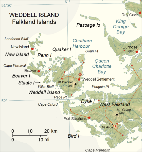
English: Upgraded topographic map of Weddell Island area, Falkland Islands |
| Date | |
| Source | File:Falkland Islands topographic map-en.svg |
| Author | Eric Gaba ( Sting), fragment revised by Apcbg |
| Camera location |
| View this and other nearby images on: OpenStreetMap |
|
|---|
Licensing
This file is licensed under the
Creative Commons
Attribution-Share Alike 3.0 Unported license.
- You are free:
- to share – to copy, distribute and transmit the work
- to remix – to adapt the work
- Under the following conditions:
- attribution – You must give appropriate credit, provide a link to the license, and indicate if changes were made. You may do so in any reasonable manner, but not in any way that suggests the licensor endorses you or your use.
- share alike – If you remix, transform, or build upon the material, you must distribute your contributions under the same or compatible license as the original.
File history
Click on a date/time to view the file as it appeared at that time.
| Date/Time | Thumbnail | Dimensions | User | Comment | |
|---|---|---|---|---|---|
| current | 07:45, 23 May 2018 |
| 588 × 630 (245 KB) | Apcbg | details |
| 11:53, 7 May 2018 |
 | 588 × 630 (190 KB) | Apcbg | detail | |
| 10:15, 27 April 2018 |
 | 588 × 630 (244 KB) | Apcbg | detail | |
| 07:15, 27 April 2018 |
 | 588 × 630 (244 KB) | Apcbg | detail | |
| 12:21, 20 April 2018 |
 | 588 × 630 (244 KB) | Apcbg | detail | |
| 07:50, 20 April 2018 |
 | 588 × 630 (244 KB) | Apcbg | details | |
| 06:44, 20 April 2018 |
 | 588 × 630 (244 KB) | Apcbg | detail | |
| 18:21, 18 April 2018 |
 | 588 × 630 (190 KB) | Apcbg | colour | |
| 09:46, 19 March 2018 |
 | 588 × 630 (243 KB) | Apcbg | detail | |
| 08:39, 19 March 2018 |
 | 588 × 630 (242 KB) | Apcbg | details |
File usage
The following pages on the English Wikipedia use this file (pages on other projects are not listed):
- Chatham Harbour, Weddell Island
- Circum Peak
- French Harbour
- Gull Harbour
- Horse Block
- Hotham Heights
- Loop Head, Weddell Island
- Mount Alice (Falkland Islands)
- Mount Weddell
- New Year Cove
- Pillar Bluff
- Pitt Heights
- Quaker Harbour
- Race Point
- Smylie Channel
- Swan Point, Weddell Island
- Weddell Island
- Weddell Point, Weddell Island
- Weddell Settlement
Global file usage
The following other wikis use this file:
- Usage on de.wikipedia.org
- Usage on fr.wikipedia.org
- Usage on www.wikidata.org
Metadata
Size of this preview:
560 × 600 pixels. Other resolutions:
224 × 240 pixels |
588 × 630 pixels.
Original file (588 × 630 pixels, file size: 245 KB, MIME type: image/png)
| This is a file from the
Wikimedia Commons. Information from its
description page there is shown below. Commons is a freely licensed media file repository. You can help. |
Summary
| Description |
English: Upgraded topographic map of Weddell Island area, Falkland Islands |
| Date | |
| Source | File:Falkland Islands topographic map-en.svg |
| Author | Eric Gaba ( Sting), fragment revised by Apcbg |
| Camera location |
| View this and other nearby images on: OpenStreetMap |
|
|---|
Licensing
This file is licensed under the
Creative Commons
Attribution-Share Alike 3.0 Unported license.
- You are free:
- to share – to copy, distribute and transmit the work
- to remix – to adapt the work
- Under the following conditions:
- attribution – You must give appropriate credit, provide a link to the license, and indicate if changes were made. You may do so in any reasonable manner, but not in any way that suggests the licensor endorses you or your use.
- share alike – If you remix, transform, or build upon the material, you must distribute your contributions under the same or compatible license as the original.
File history
Click on a date/time to view the file as it appeared at that time.
| Date/Time | Thumbnail | Dimensions | User | Comment | |
|---|---|---|---|---|---|
| current | 07:45, 23 May 2018 |
| 588 × 630 (245 KB) | Apcbg | details |
| 11:53, 7 May 2018 |
| 588 × 630 (190 KB) | Apcbg | detail | |
| 10:15, 27 April 2018 |
| 588 × 630 (244 KB) | Apcbg | detail | |
| 07:15, 27 April 2018 |
| 588 × 630 (244 KB) | Apcbg | detail | |
| 12:21, 20 April 2018 |
| 588 × 630 (244 KB) | Apcbg | detail | |
| 07:50, 20 April 2018 |
| 588 × 630 (244 KB) | Apcbg | details | |
| 06:44, 20 April 2018 |
| 588 × 630 (244 KB) | Apcbg | detail | |
| 18:21, 18 April 2018 |
| 588 × 630 (190 KB) | Apcbg | colour | |
| 09:46, 19 March 2018 |
| 588 × 630 (243 KB) | Apcbg | detail | |
| 08:39, 19 March 2018 |
| 588 × 630 (242 KB) | Apcbg | details |
File usage
The following pages on the English Wikipedia use this file (pages on other projects are not listed):
- Chatham Harbour, Weddell Island
- Circum Peak
- French Harbour
- Gull Harbour
- Horse Block
- Hotham Heights
- Loop Head, Weddell Island
- Mount Alice (Falkland Islands)
- Mount Weddell
- New Year Cove
- Pillar Bluff
- Pitt Heights
- Quaker Harbour
- Race Point
- Smylie Channel
- Swan Point, Weddell Island
- Weddell Island
- Weddell Point, Weddell Island
- Weddell Settlement
Global file usage
The following other wikis use this file:
- Usage on de.wikipedia.org
- Usage on fr.wikipedia.org
- Usage on www.wikidata.org