
Size of this PNG preview of this SVG file:
800 × 233 pixels. Other resolutions:
320 × 93 pixels |
640 × 186 pixels |
1,024 × 298 pixels |
1,280 × 372 pixels |
2,560 × 745 pixels |
2,750 × 800 pixels.
Original file (SVG file, nominally 2,750 × 800 pixels, file size: 6 KB)
| This is a file from the
Wikimedia Commons. Information from its
description page there is shown below. Commons is a freely licensed media file repository. You can help. |
Summary
| Description |
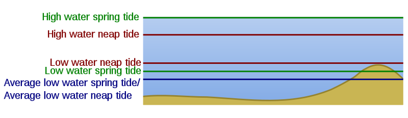
English: A schematic of the water surface level changes with the tides. Average low water spring or average low water neap tide; used as a reference, which one is used depends on whether LWN or LWS is lowest. The schematic was hand drawn based on an image from the book "Leidraad voor het Stuurbrevet" by Richard Vooren, Paul Van den Keybus. Note that the ALWS/ALWN is best replaced by LAT (lowest astronomical tide) in a next version of the image. As this water level may be lower than ALWN/ALWS, some of the text will be rendered obsolete |
| Date | |
| Source | File:Water surface level changes with tides.JPG Own work |
| Author | KVDP, SVG conversion by Surachit |
| Other versions |
|
Licensing
| I, the copyright holder of this work, release this work into the
public domain. This applies worldwide. In some countries this may not be legally possible; if so: I grant anyone the right to use this work for any purpose, without any conditions, unless such conditions are required by law. |
File history
Click on a date/time to view the file as it appeared at that time.
| Date/Time | Thumbnail | Dimensions | User | Comment | |
|---|---|---|---|---|---|
| current | 13:04, 16 December 2009 |
| 2,750 × 800 (6 KB) | Surachit | == {{int:filedesc}} == {{Information |Description={{en|1=A schematic of the water surface level changes with the tides. Average low water spring or average low water neap tide; used as a reference, which one is used depends on whether LWN or LWS is lowest |
File usage
The following pages on the English Wikipedia use this file (pages on other projects are not listed):
Global file usage
The following other wikis use this file:
- Usage on ml.wikipedia.org
- Usage on vi.wikipedia.org
Size of this PNG preview of this SVG file:
800 × 233 pixels. Other resolutions:
320 × 93 pixels |
640 × 186 pixels |
1,024 × 298 pixels |
1,280 × 372 pixels |
2,560 × 745 pixels |
2,750 × 800 pixels.
Original file (SVG file, nominally 2,750 × 800 pixels, file size: 6 KB)
| This is a file from the
Wikimedia Commons. Information from its
description page there is shown below. Commons is a freely licensed media file repository. You can help. |
Summary
| Description |
English: A schematic of the water surface level changes with the tides. Average low water spring or average low water neap tide; used as a reference, which one is used depends on whether LWN or LWS is lowest. The schematic was hand drawn based on an image from the book "Leidraad voor het Stuurbrevet" by Richard Vooren, Paul Van den Keybus. Note that the ALWS/ALWN is best replaced by LAT (lowest astronomical tide) in a next version of the image. As this water level may be lower than ALWN/ALWS, some of the text will be rendered obsolete |
| Date | |
| Source | File:Water surface level changes with tides.JPG Own work |
| Author | KVDP, SVG conversion by Surachit |
| Other versions |
|
Licensing
| I, the copyright holder of this work, release this work into the
public domain. This applies worldwide. In some countries this may not be legally possible; if so: I grant anyone the right to use this work for any purpose, without any conditions, unless such conditions are required by law. |
File history
Click on a date/time to view the file as it appeared at that time.
| Date/Time | Thumbnail | Dimensions | User | Comment | |
|---|---|---|---|---|---|
| current | 13:04, 16 December 2009 |
| 2,750 × 800 (6 KB) | Surachit | == {{int:filedesc}} == {{Information |Description={{en|1=A schematic of the water surface level changes with the tides. Average low water spring or average low water neap tide; used as a reference, which one is used depends on whether LWN or LWS is lowest |
File usage
The following pages on the English Wikipedia use this file (pages on other projects are not listed):
Global file usage
The following other wikis use this file:
- Usage on ml.wikipedia.org
- Usage on vi.wikipedia.org