Original file (1,078 × 1,750 pixels, file size: 235 KB, MIME type: image/jpeg)
| This image may not have the proper
copyright or licensing information, or there is a conflict of license. An experienced editor should contact the uploader and add the proper tag, or discuss the issue on the talk page. If the image has no source, add {{
subst:Di-no source}}. If the image has no licensing information, add {{
subst:Di-no license}}. If the copyright tag may need discussion, please list at
Wikipedia:Files for discussion. |
Summary
| Description |
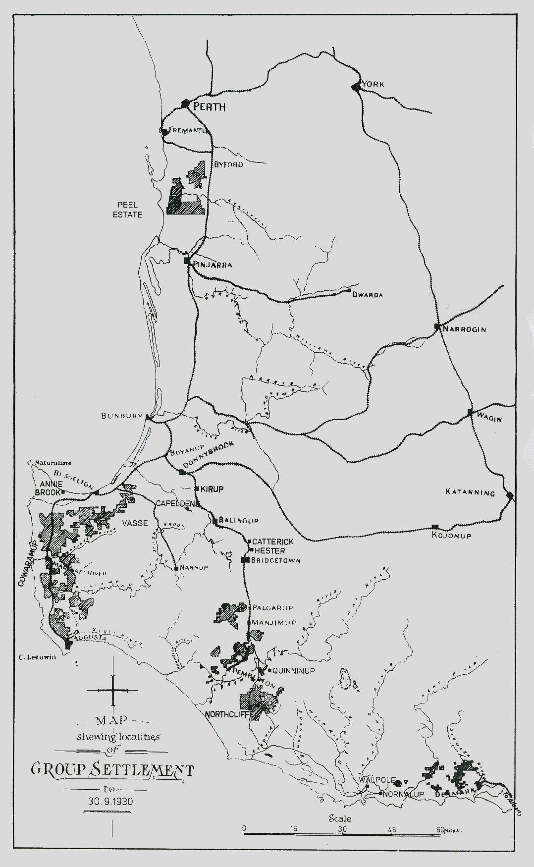
Map of the Western Australian Group Settlement Schemes | ||
|---|---|---|---|
| Source |
Source: Group Settlement: Its Origins : Politics and Administration, by J. P. Gabbedy | ||
| Date |
Map was made in the 1930s | ||
| Author |
| ||
| Permission ( Reusing this file) |
See below.
|
Licensing
This image was created in Australia and is now classified as being in the
public domain because its term of copyright has now expired. According to the
Information Sheet G023v17 (Duration of copyright) (Aug 2014), generally copyright has expired as follows: In 2015, 70-year copyrights under the AUSFTA start expiring.[
needs update]
1means the typographical arrangement and layout of a published work. eg. newsprint. |  | ||||||||||||||||||||||||||||||||||
|
File history
Click on a date/time to view the file as it appeared at that time.
| Date/Time | Thumbnail | Dimensions | User | Comment | |
|---|---|---|---|---|---|
| current | 04:16, 16 November 2006 |
| 1,078 × 1,750 (235 KB) | Moondyne ( talk | contribs) | |
| 04:09, 16 November 2006 |
 | 1,078 × 1,750 (235 KB) | Moondyne ( talk | contribs) | Map of the Western Australian Group Settlement Schemes Source: Group Settlement: Its Origins : Politics and Administration, by J. P. Gabbedy ==Licensing== Map was made in the 1930s and is therefore in the public domain in Australia {{PD-Australia}} |
You cannot overwrite this file.
File usage
Metadata
Original file (1,078 × 1,750 pixels, file size: 235 KB, MIME type: image/jpeg)
| This image may not have the proper
copyright or licensing information, or there is a conflict of license. An experienced editor should contact the uploader and add the proper tag, or discuss the issue on the talk page. If the image has no source, add {{
subst:Di-no source}}. If the image has no licensing information, add {{
subst:Di-no license}}. If the copyright tag may need discussion, please list at
Wikipedia:Files for discussion. |
Summary
| Description |
Map of the Western Australian Group Settlement Schemes | ||
|---|---|---|---|
| Source |
Source: Group Settlement: Its Origins : Politics and Administration, by J. P. Gabbedy | ||
| Date |
Map was made in the 1930s | ||
| Author |
| ||
| Permission ( Reusing this file) |
See below.
|
Licensing
This image was created in Australia and is now classified as being in the
public domain because its term of copyright has now expired. According to the
Information Sheet G023v17 (Duration of copyright) (Aug 2014), generally copyright has expired as follows: In 2015, 70-year copyrights under the AUSFTA start expiring.[
needs update]
1means the typographical arrangement and layout of a published work. eg. newsprint. | | ||||||||||||||||||||||||||||||||||
| |||||||||||||||||||||||||||||||||||
File history
Click on a date/time to view the file as it appeared at that time.
| Date/Time | Thumbnail | Dimensions | User | Comment | |
|---|---|---|---|---|---|
| current | 04:16, 16 November 2006 |
| 1,078 × 1,750 (235 KB) | Moondyne ( talk | contribs) | |
| 04:09, 16 November 2006 |
| 1,078 × 1,750 (235 KB) | Moondyne ( talk | contribs) | Map of the Western Australian Group Settlement Schemes Source: Group Settlement: Its Origins : Politics and Administration, by J. P. Gabbedy ==Licensing== Map was made in the 1930s and is therefore in the public domain in Australia {{PD-Australia}} |
You cannot overwrite this file.