Size of this preview:
566 × 599 pixels. Other resolutions:
227 × 240 pixels |
453 × 480 pixels |
786 × 832 pixels.
Original file (786 × 832 pixels, file size: 197 KB, MIME type: image/jpeg)
| This is a file from the
Wikimedia Commons. Information from its
description page there is shown below. Commons is a freely licensed media file repository. You can help. |
Summary
| Description |
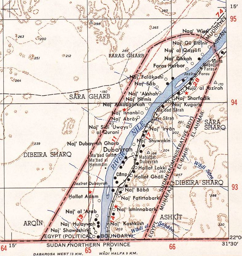
English: North Africa 1:250,000
Sheet NF 36-5 in the southeast is the Wadi Halfa Salient, with the situation before the flooding by the Aswan Dam and Lake Nasser |
| Date | |
| Source | http://www.lib.utexas.edu/maps/ams/north_africa/txu-oclc-6949452-nf36-5.jpg |
| Author | Army Map Service (LD), Corps of Engineers, U.S. Army |
| Other versions |
 |
Licensing
This file is a work of a
U.S. Army soldier or employee, taken or made as part of that person's official duties. As a
work of the
U.S. federal government, it is in the
public domain in the United States.
|
 |
File history
Click on a date/time to view the file as it appeared at that time.
| Date/Time | Thumbnail | Dimensions | User | Comment | |
|---|---|---|---|---|---|
| current | 03:08, 15 July 2014 |
| 786 × 832 (197 KB) | Beyond My Ken | == {{int:filedesc}} == {{Information |Description={{en|1=North Africa 1:250,000 Sheet NF 36-5 in the southeast is the Wadi Halfa Salient, with the situation before the flooding by the Aswan Dam and Lake Nasser }} |Source=http://www.lib.utexas.edu/maps/... |
File usage
The following pages on the English Wikipedia use this file (pages on other projects are not listed):
Global file usage
The following other wikis use this file:
- Usage on ar.wikipedia.org
- Usage on ja.wikipedia.org
Size of this preview:
566 × 599 pixels. Other resolutions:
227 × 240 pixels |
453 × 480 pixels |
786 × 832 pixels.
Original file (786 × 832 pixels, file size: 197 KB, MIME type: image/jpeg)
| This is a file from the
Wikimedia Commons. Information from its
description page there is shown below. Commons is a freely licensed media file repository. You can help. |
Summary
| Description |
English: North Africa 1:250,000
Sheet NF 36-5 in the southeast is the Wadi Halfa Salient, with the situation before the flooding by the Aswan Dam and Lake Nasser |
| Date | |
| Source | http://www.lib.utexas.edu/maps/ams/north_africa/txu-oclc-6949452-nf36-5.jpg |
| Author | Army Map Service (LD), Corps of Engineers, U.S. Army |
| Other versions |
|
Licensing
This file is a work of a
U.S. Army soldier or employee, taken or made as part of that person's official duties. As a
work of the
U.S. federal government, it is in the
public domain in the United States.
|
|
File history
Click on a date/time to view the file as it appeared at that time.
| Date/Time | Thumbnail | Dimensions | User | Comment | |
|---|---|---|---|---|---|
| current | 03:08, 15 July 2014 |
| 786 × 832 (197 KB) | Beyond My Ken | == {{int:filedesc}} == {{Information |Description={{en|1=North Africa 1:250,000 Sheet NF 36-5 in the southeast is the Wadi Halfa Salient, with the situation before the flooding by the Aswan Dam and Lake Nasser }} |Source=http://www.lib.utexas.edu/maps/... |
File usage
The following pages on the English Wikipedia use this file (pages on other projects are not listed):
Global file usage
The following other wikis use this file:
- Usage on ar.wikipedia.org
- Usage on ja.wikipedia.org