
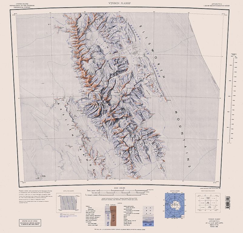
Original file (3,207 × 3,070 pixels, file size: 5.48 MB, MIME type: image/jpeg)
| This is a file from the
Wikimedia Commons. Information from its
description page there is shown below. Commons is a freely licensed media file repository. You can help. |
| Description |
English: Map of Antarctica by the United States Antarctic Resource Center of the US Geological Survey (USGS). |
| Date | |
| Source | https://usarc.usgs.gov/drgs/dir1/c78082s1.jpg |
| Author | United States Department of the Interior: Geological Survey |
| Other versions |
Trimmed and updated version of Wikimedia Commons
Image:C78082s1_Ant.Map_Vinson_Massif.jpg. |
This image is in the
public domain in the United States because it only contains materials that originally came from the
United States Geological Survey, an agency of the
United States Department of the Interior. For more information, see
the official USGS copyright policy.
|
File history
Click on a date/time to view the file as it appeared at that time.
| Date/Time | Thumbnail | Dimensions | User | Comment | |
|---|---|---|---|---|---|
| current | 16:25, 22 January 2014 |
| 3,207 × 3,070 (5.48 MB) | Apcbg | Updated with data from SCAR Composite Gazetteer of Antarctica and other sources. |
| 07:11, 27 August 2013 |
 | 3,207 × 3,070 (5.47 MB) | Apcbg | Updated with data from SCAR Composite Gazetteer of Antarctica and other sources. | |
| 16:34, 9 July 2011 |
 | 3,207 × 3,070 (5.46 MB) | Apcbg | Updated with data from SCAR Composite Gazetteer of Antarctica and other sources. | |
| 17:34, 8 March 2011 |
 | 3,207 × 3,070 (5.47 MB) | Apcbg | Updated with data from SCAR Composite Gazetteer of Antarctica and other sources. | |
| 16:52, 13 October 2010 |
 | 3,207 × 3,070 (5.45 MB) | Apcbg | Updated with data from SCAR Composite Gazetteer of Antarctica and other sources. | |
| 10:27, 30 January 2007 |
 | 3,207 × 3,070 (5.4 MB) | Apcbg | Map of Antarctica by the United States Antarctic Ressource Center of the US Geological Society. Trimmed version of Wikimedia image C78082s1_Ant.Map_Vinson_Massif.jpg {{PD-US}} Copyrights and Trademarks USGS-authored or produced data and information are |
File usage
More than 100 pages use this file. The following list shows the first 100 pages that use this file only. A full list is available.
- Arapya Glacier
- Barnes Ridge (Antarctica)
- Bastien Range
- Bolgrad Glacier
- Bowers Corner
- Branscomb Glacier
- Brichebor Peak (Antarctica)
- Brook Glacier
- Carey Glacier
- Chapman Peak (Antarctica)
- Composite Gazetteer of Antarctica
- Craddock Massif
- Crosswell Glacier
- Dater Glacier
- Dickey Peak
- Drama Glacier
- Ellen Glacier
- Ellsworth Mountains
- Embree Glacier
- Evans Peak
- Eyer Peak
- Flowers Hills
- Galicia Peak
- Gildea Glacier
- Guerrero Glacier
- Hammer Col
- Hansen Glacier
- Hough Glacier
- Hudman Glacier
- Jacobsen Valley
- Johnson Col
- Johnson Spur
- Karnare Col
- Krusha Peak
- Lishness Peak
- Long Gables
- Long Peak
- Marze Peak
- McPherson Peak
- Miller Peak (Sentinel Range)
- Minnesota Glacier
- Mount Anderson (Antarctica)
- Mount Atkinson
- Mount Bearskin
- Mount Benson (Antarctica)
- Mount Bentley
- Mount Craddock
- Mount Davis (Antarctica)
- Mount Epperly
- Mount Gardner
- Mount Giovinetto
- Mount Gozur
- Mount Havener
- Mount Hubley (Antarctica)
- Mount Inderbitzen
- Mount Jumper
- Mount Landolt
- Mount Levack
- Mount Liptak
- Mount Milton
- Mount Mohl
- Mount Morris (Antarctica)
- Mount Osborne
- Mount Ostenso
- Mount Press
- Mount Rutford
- Mount Segers
- Mount Shear
- Mount Shinn
- Mount Sisu
- Mount Slaughter
- Mount Southwick
- Mount Strybing
- Mount Todd
- Mount Tuck
- Mount Tyree
- Mount Viets
- Mount Waldron
- Mountainview Ridge
- Nimitz Glacier
- Obelya Glacier
- Opalchenie Peak
- Owen Ridge
- Patleyna Glacier
- Patton Glacier
- Probuda Ridge
- Príncipe de Asturias Peak
- Remington Glacier
- Roberts Peak
- Roché Glacier
- Rumyana Glacier
- Rutford Ice Stream
- Sentinel Range
- Sirma Glacier
- Sullivan Heights
- Taylor Spur
- Thomas Glacier
- Vinson Massif
- Vinson Plateau
- Wessbecher Glacier
View more links to this file.
Global file usage
The following other wikis use this file:
- Usage on ar.wikipedia.org
- Usage on ast.wikipedia.org
- Usage on az.wikipedia.org
- Mirovyane zirvəsi
- Zimornitsa zirvəsi
- Fuça zirvəsi
- Bezden zirvəsi
- Oreşak zirvəsi
- Qolemani zirvəsi
- Marsa buzlağı
- Patleyna buzlağı
- Embree buzlağı
- Kopsis buzlağı
- Padala buzlağı
- Ellen buzlağı
- Fonfon buzlağı
- Gerila buzlağı
- Rumyana buzlağı
- Delyo buzlağı
- Burdenis buzlağı
- Arapya buzlağı
- Pulpudeva buzlağı
- Mamarçev zirvəsi
- Rutford
- Usage on bg.wikipedia.org
- Usage on ca.wikipedia.org
- Usage on ceb.wikipedia.org
View more global usage of this file.
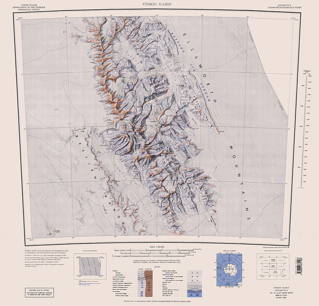
Original file (3,207 × 3,070 pixels, file size: 5.48 MB, MIME type: image/jpeg)
| This is a file from the
Wikimedia Commons. Information from its
description page there is shown below. Commons is a freely licensed media file repository. You can help. |
| Description |
English: Map of Antarctica by the United States Antarctic Resource Center of the US Geological Survey (USGS). |
| Date | |
| Source | https://usarc.usgs.gov/drgs/dir1/c78082s1.jpg |
| Author | United States Department of the Interior: Geological Survey |
| Other versions |
Trimmed and updated version of Wikimedia Commons
Image:C78082s1_Ant.Map_Vinson_Massif.jpg. |
This image is in the
public domain in the United States because it only contains materials that originally came from the
United States Geological Survey, an agency of the
United States Department of the Interior. For more information, see
the official USGS copyright policy.
|
File history
Click on a date/time to view the file as it appeared at that time.
| Date/Time | Thumbnail | Dimensions | User | Comment | |
|---|---|---|---|---|---|
| current | 16:25, 22 January 2014 |
| 3,207 × 3,070 (5.48 MB) | Apcbg | Updated with data from SCAR Composite Gazetteer of Antarctica and other sources. |
| 07:11, 27 August 2013 |
| 3,207 × 3,070 (5.47 MB) | Apcbg | Updated with data from SCAR Composite Gazetteer of Antarctica and other sources. | |
| 16:34, 9 July 2011 |
| 3,207 × 3,070 (5.46 MB) | Apcbg | Updated with data from SCAR Composite Gazetteer of Antarctica and other sources. | |
| 17:34, 8 March 2011 |
| 3,207 × 3,070 (5.47 MB) | Apcbg | Updated with data from SCAR Composite Gazetteer of Antarctica and other sources. | |
| 16:52, 13 October 2010 |
| 3,207 × 3,070 (5.45 MB) | Apcbg | Updated with data from SCAR Composite Gazetteer of Antarctica and other sources. | |
| 10:27, 30 January 2007 |
| 3,207 × 3,070 (5.4 MB) | Apcbg | Map of Antarctica by the United States Antarctic Ressource Center of the US Geological Society. Trimmed version of Wikimedia image C78082s1_Ant.Map_Vinson_Massif.jpg {{PD-US}} Copyrights and Trademarks USGS-authored or produced data and information are |
File usage
More than 100 pages use this file. The following list shows the first 100 pages that use this file only. A full list is available.
- Arapya Glacier
- Barnes Ridge (Antarctica)
- Bastien Range
- Bolgrad Glacier
- Bowers Corner
- Branscomb Glacier
- Brichebor Peak (Antarctica)
- Brook Glacier
- Carey Glacier
- Chapman Peak (Antarctica)
- Composite Gazetteer of Antarctica
- Craddock Massif
- Crosswell Glacier
- Dater Glacier
- Dickey Peak
- Drama Glacier
- Ellen Glacier
- Ellsworth Mountains
- Embree Glacier
- Evans Peak
- Eyer Peak
- Flowers Hills
- Galicia Peak
- Gildea Glacier
- Guerrero Glacier
- Hammer Col
- Hansen Glacier
- Hough Glacier
- Hudman Glacier
- Jacobsen Valley
- Johnson Col
- Johnson Spur
- Karnare Col
- Krusha Peak
- Lishness Peak
- Long Gables
- Long Peak
- Marze Peak
- McPherson Peak
- Miller Peak (Sentinel Range)
- Minnesota Glacier
- Mount Anderson (Antarctica)
- Mount Atkinson
- Mount Bearskin
- Mount Benson (Antarctica)
- Mount Bentley
- Mount Craddock
- Mount Davis (Antarctica)
- Mount Epperly
- Mount Gardner
- Mount Giovinetto
- Mount Gozur
- Mount Havener
- Mount Hubley (Antarctica)
- Mount Inderbitzen
- Mount Jumper
- Mount Landolt
- Mount Levack
- Mount Liptak
- Mount Milton
- Mount Mohl
- Mount Morris (Antarctica)
- Mount Osborne
- Mount Ostenso
- Mount Press
- Mount Rutford
- Mount Segers
- Mount Shear
- Mount Shinn
- Mount Sisu
- Mount Slaughter
- Mount Southwick
- Mount Strybing
- Mount Todd
- Mount Tuck
- Mount Tyree
- Mount Viets
- Mount Waldron
- Mountainview Ridge
- Nimitz Glacier
- Obelya Glacier
- Opalchenie Peak
- Owen Ridge
- Patleyna Glacier
- Patton Glacier
- Probuda Ridge
- Príncipe de Asturias Peak
- Remington Glacier
- Roberts Peak
- Roché Glacier
- Rumyana Glacier
- Rutford Ice Stream
- Sentinel Range
- Sirma Glacier
- Sullivan Heights
- Taylor Spur
- Thomas Glacier
- Vinson Massif
- Vinson Plateau
- Wessbecher Glacier
View more links to this file.
Global file usage
The following other wikis use this file:
- Usage on ar.wikipedia.org
- Usage on ast.wikipedia.org
- Usage on az.wikipedia.org
- Mirovyane zirvəsi
- Zimornitsa zirvəsi
- Fuça zirvəsi
- Bezden zirvəsi
- Oreşak zirvəsi
- Qolemani zirvəsi
- Marsa buzlağı
- Patleyna buzlağı
- Embree buzlağı
- Kopsis buzlağı
- Padala buzlağı
- Ellen buzlağı
- Fonfon buzlağı
- Gerila buzlağı
- Rumyana buzlağı
- Delyo buzlağı
- Burdenis buzlağı
- Arapya buzlağı
- Pulpudeva buzlağı
- Mamarçev zirvəsi
- Rutford
- Usage on bg.wikipedia.org
- Usage on ca.wikipedia.org
- Usage on ceb.wikipedia.org
View more global usage of this file.