Size of this preview:
360 × 600 pixels. Other resolutions:
144 × 240 pixels |
428 × 713 pixels.
Original file (428 × 713 pixels, file size: 15 KB, MIME type: image/gif)
| This is a file from the
Wikimedia Commons. Information from its
description page there is shown below. Commons is a freely licensed media file repository. You can help. |
Summary
| Description |
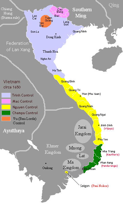
English: More accurate borders in 1650: Trinh Nguyen border at Giang river. Bau Lords still hold out at Yen Bai and Tuyen Quang provinces. Champa as rump states of Hoa Anh and Panduranga still hold out at today's Khanh Hoa province. |
|||||
| Date | ||||||
| Source | Own work based on Gryffindor's map | |||||
| Author | Own work by uploader | |||||
| Permission ( Reusing this file) |
I, the copyright holder of this work, hereby publish it under the following licenses:
This file is licensed under the
Creative Commons
Attribution 2.5 Generic license.
You may select the license of your choice. |

Licensing
| I, the copyright holder of this work, release this work into the
public domain. This applies worldwide. In some countries this may not be legally possible; if so: I grant anyone the right to use this work for any purpose, without any conditions, unless such conditions are required by law. |

|
This historical map image could be re-created using
vector graphics as an
SVG file. This has several advantages; see
Commons:Media for cleanup for more information. If an SVG form of this image is available, please upload it and afterwards replace this template with
{{
vector version available|new image name}}
.
It is recommended to name the SVG file “Vietnam1650.svg”—then the template Vector version available (or Vva) does not need the new image name parameter. |
File history
Click on a date/time to view the file as it appeared at that time.
| Date/Time | Thumbnail | Dimensions | User | Comment | |
|---|---|---|---|---|---|
| current | 06:25, 1 April 2013 |
| 428 × 713 (15 KB) | Sgnpkd | {{Information |Description ={{en|1=More accurate borders in 1650: Trinh Nguyen border at Giang river. Bau Lords still hold out at Yen Bai and Tuyen Quang provinces. Champa as rump states of Hoa Anh and Panduranga still hold out at today's Khanh Hoa ... |
File usage
The following pages on the English Wikipedia use this file (pages on other projects are not listed):
Global file usage
The following other wikis use this file:
- Usage on ar.wikipedia.org
- Usage on ba.wikipedia.org
- Usage on bn.wikipedia.org
- Usage on ceb.wikipedia.org
- Usage on da.wikipedia.org
- Usage on de.wikipedia.org
- Usage on fi.wikipedia.org
- Usage on fr.wikipedia.org
- Usage on he.wikipedia.org
- Usage on id.wikipedia.org
- Usage on it.wikipedia.org
- Usage on ja.wikipedia.org
- Usage on km.wikipedia.org
- Usage on ko.wikipedia.org
- Usage on no.wikipedia.org
- Usage on pt.wikipedia.org
- Usage on ru.wikipedia.org
- Usage on sl.wikipedia.org
- Usage on sv.wikipedia.org
- Usage on th.wikipedia.org
- Usage on uk.wikipedia.org
- Usage on vi.wikipedia.org
- Usage on zh.wikipedia.org
View more global usage of this file.
Size of this preview:
360 × 600 pixels. Other resolutions:
144 × 240 pixels |
428 × 713 pixels.
Original file (428 × 713 pixels, file size: 15 KB, MIME type: image/gif)
| This is a file from the
Wikimedia Commons. Information from its
description page there is shown below. Commons is a freely licensed media file repository. You can help. |
Summary
| Description |
English: More accurate borders in 1650: Trinh Nguyen border at Giang river. Bau Lords still hold out at Yen Bai and Tuyen Quang provinces. Champa as rump states of Hoa Anh and Panduranga still hold out at today's Khanh Hoa province. |
|||||
| Date | ||||||
| Source | Own work based on Gryffindor's map | |||||
| Author | Own work by uploader | |||||
| Permission ( Reusing this file) |
I, the copyright holder of this work, hereby publish it under the following licenses:
This file is licensed under the
Creative Commons
Attribution 2.5 Generic license.
You may select the license of your choice. |
Licensing
| I, the copyright holder of this work, release this work into the
public domain. This applies worldwide. In some countries this may not be legally possible; if so: I grant anyone the right to use this work for any purpose, without any conditions, unless such conditions are required by law. |
|
|
This historical map image could be re-created using
vector graphics as an
SVG file. This has several advantages; see
Commons:Media for cleanup for more information. If an SVG form of this image is available, please upload it and afterwards replace this template with
{{
vector version available|new image name}}
.
It is recommended to name the SVG file “Vietnam1650.svg”—then the template Vector version available (or Vva) does not need the new image name parameter. |
File history
Click on a date/time to view the file as it appeared at that time.
| Date/Time | Thumbnail | Dimensions | User | Comment | |
|---|---|---|---|---|---|
| current | 06:25, 1 April 2013 |
| 428 × 713 (15 KB) | Sgnpkd | {{Information |Description ={{en|1=More accurate borders in 1650: Trinh Nguyen border at Giang river. Bau Lords still hold out at Yen Bai and Tuyen Quang provinces. Champa as rump states of Hoa Anh and Panduranga still hold out at today's Khanh Hoa ... |
File usage
The following pages on the English Wikipedia use this file (pages on other projects are not listed):
Global file usage
The following other wikis use this file:
- Usage on ar.wikipedia.org
- Usage on ba.wikipedia.org
- Usage on bn.wikipedia.org
- Usage on ceb.wikipedia.org
- Usage on da.wikipedia.org
- Usage on de.wikipedia.org
- Usage on fi.wikipedia.org
- Usage on fr.wikipedia.org
- Usage on he.wikipedia.org
- Usage on id.wikipedia.org
- Usage on it.wikipedia.org
- Usage on ja.wikipedia.org
- Usage on km.wikipedia.org
- Usage on ko.wikipedia.org
- Usage on no.wikipedia.org
- Usage on pt.wikipedia.org
- Usage on ru.wikipedia.org
- Usage on sl.wikipedia.org
- Usage on sv.wikipedia.org
- Usage on th.wikipedia.org
- Usage on uk.wikipedia.org
- Usage on vi.wikipedia.org
- Usage on zh.wikipedia.org
View more global usage of this file.