
Original file (SVG file, nominally 3,331 × 1,871 pixels, file size: 9.49 MB)
| This is a file from the
Wikimedia Commons. Information from its
description page there is shown below. Commons is a freely licensed media file repository. You can help. |
Summary
| Description |
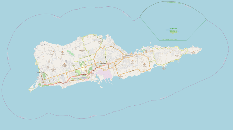
English: United States Virgin Islands Saint Croix location map with boundries of top=17.7964, left=-64.9182, right=-64.5502, bottom=17.6659 |
| Date | |
| Source | https://www.openstreetmap.org/export#map=12/17.7240/-64.7222&layers=H |
| Author | OpenStreetMap contributors |
| SVG development |

| Description |
SVG generated from openstreetmap.org export feature of Saint Croix. This map of Saint Croix was created from
OpenStreetMap project data, collected by the community. This map may be incomplete, and may contain errors. Don't rely solely on it for navigation. |
|||
| Date | ||||
| Source | You may find a page on the OpenStreetMap wiki page for Saint Croix | |||
| Creator |
OpenStreetMap contributors |
|||
| Permission ( Reusing this file) |
OpenStreetMap data is available under the Open Database License ( details). Map tiles are licensed under the Creative Commons Attribution-ShareAlike 2.0 license (CC-BY-SA 2.0).
This file is licensed under the
Creative Commons
Attribution-Share Alike 2.0 Generic license.
|
|||
| Georeferencing | If inappropriate please set warp_status = skip to hide. |
Licensing
File history
Click on a date/time to view the file as it appeared at that time.
| Date/Time | Thumbnail | Dimensions | User | Comment | |
|---|---|---|---|---|---|
| current | 14:15, 7 May 2020 |
| 3,331 × 1,871 (9.49 MB) | Pwhite098 | Updated map with SVG from openstreetmap.org |
| 09:08, 4 May 2020 |
| 1,077 × 405 (167 KB) | Trần Nguyễn Minh Huy | Reverted to version as of 17:27, 8 March 2017 (UTC) already used in locator map, can not upload with the new geocode | |
| 09:03, 4 May 2020 |
 | 1,444 × 723 (5.33 MB) | Trần Nguyễn Minh Huy | better SVG map (extract from OSM) | |
| 17:27, 8 March 2017 |
| 1,077 × 405 (167 KB) | Id4abel | User created page with UploadWizard |
File usage
- Altona, Saint Croix, U.S. Virgin Islands
- Annaberg, Saint Croix, U.S. Virgin Islands
- Bellevue, Saint Croix, U.S. Virgin Islands
- Bonne Esperance, Saint Croix, U.S. Virgin Islands
- Buck Island Reef National Monument
- Christiansted, U.S. Virgin Islands
- Christiansted Harbor Seaplane Base
- Christiansted National Historic Site
- Concordia, Saint Croix, U.S. Virgin Islands
- Cruzan Rum
- Danish West India and Guinea Company Warehouse
- Diamond School
- Estate Little Princess
- Fort Frederik
- Frederiks Haab, U.S. Virgin Islands
- Frederiksted, U.S. Virgin Islands
- Frederiksted Historic District
- Frederiksted Pier
- Friedensfeld, U.S. Virgin Islands
- Friedensfeld Midlands Moravian Church and Manse
- Great Pond, U.S. Virgin Islands
- Green Cay National Wildlife Refuge
- Green Kay, U.S. Virgin Islands
- Hermitage, Saint Croix, U.S. Virgin Islands
- Mount Eagle (U.S. Virgin Islands)
- Mount Pleasant, Saint Croix, U.S. Virgin Islands
- National Capital Area Council
- Point Udall (U.S. Virgin Islands)
- Protestant Cay
- Richmond Prison Detention and Workhouse
- Saint Croix
- Salt River Bay National Historical Park and Ecological Preserve
- Sandy Point National Wildlife Refuge
- Scouting in the United States Virgin Islands
- Sion Hill, U.S. Virgin Islands
- Slob Historic District
- St. George Village Botanical Garden
- St. John's Episcopal Church (Christiansted, U.S. Virgin Islands)
- St Croix East End Marine Park
- Whim (United States Virgin Islands)
- User:AridCeption/sandbox
- Module:Location map/data/USA VI Saint Croix
- Module:Location map/data/USA VI Saint Croix/doc
Global file usage
The following other wikis use this file:
- Usage on azb.wikipedia.org
- Usage on fa.wikipedia.org
- Usage on fr.wikipedia.org
- Usage on si.wikipedia.org
- Usage on sr.wikipedia.org
Metadata
Original file (SVG file, nominally 3,331 × 1,871 pixels, file size: 9.49 MB)
| This is a file from the
Wikimedia Commons. Information from its
description page there is shown below. Commons is a freely licensed media file repository. You can help. |
Summary
| Description |
English: United States Virgin Islands Saint Croix location map with boundries of top=17.7964, left=-64.9182, right=-64.5502, bottom=17.6659 |
| Date | |
| Source | https://www.openstreetmap.org/export#map=12/17.7240/-64.7222&layers=H |
| Author | OpenStreetMap contributors |
| SVG development |
| Description |
SVG generated from openstreetmap.org export feature of Saint Croix. This map of Saint Croix was created from
OpenStreetMap project data, collected by the community. This map may be incomplete, and may contain errors. Don't rely solely on it for navigation. |
|||
| Date | ||||
| Source | You may find a page on the OpenStreetMap wiki page for Saint Croix | |||
| Creator |
OpenStreetMap contributors |
|||
| Permission ( Reusing this file) |
OpenStreetMap data is available under the Open Database License ( details). Map tiles are licensed under the Creative Commons Attribution-ShareAlike 2.0 license (CC-BY-SA 2.0).
This file is licensed under the
Creative Commons
Attribution-Share Alike 2.0 Generic license.
|
|||
| Georeferencing | If inappropriate please set warp_status = skip to hide. |
Licensing
File history
Click on a date/time to view the file as it appeared at that time.
| Date/Time | Thumbnail | Dimensions | User | Comment | |
|---|---|---|---|---|---|
| current | 14:15, 7 May 2020 |
| 3,331 × 1,871 (9.49 MB) | Pwhite098 | Updated map with SVG from openstreetmap.org |
| 09:08, 4 May 2020 |
| 1,077 × 405 (167 KB) | Trần Nguyễn Minh Huy | Reverted to version as of 17:27, 8 March 2017 (UTC) already used in locator map, can not upload with the new geocode | |
| 09:03, 4 May 2020 |
| 1,444 × 723 (5.33 MB) | Trần Nguyễn Minh Huy | better SVG map (extract from OSM) | |
| 17:27, 8 March 2017 |
| 1,077 × 405 (167 KB) | Id4abel | User created page with UploadWizard |
File usage
- Altona, Saint Croix, U.S. Virgin Islands
- Annaberg, Saint Croix, U.S. Virgin Islands
- Bellevue, Saint Croix, U.S. Virgin Islands
- Bonne Esperance, Saint Croix, U.S. Virgin Islands
- Buck Island Reef National Monument
- Christiansted, U.S. Virgin Islands
- Christiansted Harbor Seaplane Base
- Christiansted National Historic Site
- Concordia, Saint Croix, U.S. Virgin Islands
- Cruzan Rum
- Danish West India and Guinea Company Warehouse
- Diamond School
- Estate Little Princess
- Fort Frederik
- Frederiks Haab, U.S. Virgin Islands
- Frederiksted, U.S. Virgin Islands
- Frederiksted Historic District
- Frederiksted Pier
- Friedensfeld, U.S. Virgin Islands
- Friedensfeld Midlands Moravian Church and Manse
- Great Pond, U.S. Virgin Islands
- Green Cay National Wildlife Refuge
- Green Kay, U.S. Virgin Islands
- Hermitage, Saint Croix, U.S. Virgin Islands
- Mount Eagle (U.S. Virgin Islands)
- Mount Pleasant, Saint Croix, U.S. Virgin Islands
- National Capital Area Council
- Point Udall (U.S. Virgin Islands)
- Protestant Cay
- Richmond Prison Detention and Workhouse
- Saint Croix
- Salt River Bay National Historical Park and Ecological Preserve
- Sandy Point National Wildlife Refuge
- Scouting in the United States Virgin Islands
- Sion Hill, U.S. Virgin Islands
- Slob Historic District
- St. George Village Botanical Garden
- St. John's Episcopal Church (Christiansted, U.S. Virgin Islands)
- St Croix East End Marine Park
- Whim (United States Virgin Islands)
- User:AridCeption/sandbox
- Module:Location map/data/USA VI Saint Croix
- Module:Location map/data/USA VI Saint Croix/doc
Global file usage
The following other wikis use this file:
- Usage on azb.wikipedia.org
- Usage on fa.wikipedia.org
- Usage on fr.wikipedia.org
- Usage on si.wikipedia.org
- Usage on sr.wikipedia.org