
Original file (880 × 1,240 pixels, file size: 684 KB, MIME type: image/png)
| This is a file from the
Wikimedia Commons. Information from its
description page there is shown below. Commons is a freely licensed media file repository. You can help. |
| Description |
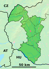
Background map of the Trnava Region, Slovakia, ready for the Geobox template, calibrated at en:Template:Geobox locator Trnava Region Outline map of the Trnava Region, Slovakia, ready for the Geobox template, calibrated at en:Template:Geobox locator Trnava Region |
| Date | (UTC) |
| Source | |
| Author |
|
| This is a
retouched picture, which means that it has been digitally altered from its original version. Modifications: fusion. The original can be viewed here:
Trnava Region - outline map.svg:
|
- You are free:
- to share – to copy, distribute and transmit the work
- to remix – to adapt the work
- Under the following conditions:
- attribution – You must give appropriate credit, provide a link to the license, and indicate if changes were made. You may do so in any reasonable manner, but not in any way that suggests the licensor endorses you or your use.
- share alike – If you remix, transform, or build upon the material, you must distribute your contributions under the same or compatible license as the original.
Original upload log
This image is a derivative work of the following images:
-
File:Trnava_Region_-_background_map.png licensed with PD-Demis
- 2007-10-27T20:31:17Z Caroig 880x1240 (916063 Bytes)
- 2007-10-27T20:25:24Z Caroig 880x1240 (919490 Bytes) fixed alignment
- 2007-10-27T19:52:08Z Caroig 880x1240 (919490 Bytes) == Summary == {{Information |Description=Background map of the Trnava Region, Slovakia, ready for the [[:en:Template:Geobox|Geobox]] template, calibrated at [[:en:Template:Geobox locator Trnava Region]] |Source=Made my myself
-
File:Trnava_Region_-_outline_map.svg licensed with Cc-by-sa-3.0,2.5,2.0,1.0, GFDL
- 2007-10-27T19:50:33Z Caroig 1100x1550 (122371 Bytes) == Summary == {{Information |Description=Outline map of the Trnava Region, Slovakia, ready for the [[:en:Template:Geobox|Geobox]] template, calibrated at [[:en:Template:Geobox locator Trnava Region]] |Source=self-made |Date=2
Uploaded with derivativeFX
File history
Click on a date/time to view the file as it appeared at that time.
| Date/Time | Thumbnail | Dimensions | User | Comment | |
|---|---|---|---|---|---|
| current | 21:36, 25 May 2014 |
| 880 × 1,240 (684 KB) | Sudo77(new) | Reverted to version as of 21:28, 25 May 2014 |
| 21:35, 25 May 2014 |
 | 880 × 1,240 (684 KB) | Sudo77(new) | x | |
| 21:28, 25 May 2014 |
 | 880 × 1,240 (684 KB) | Sudo77(new) | Trnava Region only | |
| 16:25, 27 September 2010 |
 | 880 × 1,240 (3.13 MB) | Adehertogh | {{Information |Description=Background map of the Trnava Region, Slovakia, ready for the Geobox template, calibrated at en:Template:Geobox locator Trnava Region Outline map of the Trnava Region, Slovakia, ready for the [[:en:Te |
File usage
More than 100 pages use this file. The following list shows the first 100 pages that use this file only. A full list is available.
- Abrahám
- Banka, Piešťany District
- Biely Kostol
- Bohdanovce nad Trnavou
- Bojničky
- Boleráz
- Borová, Trnava District
- Brestovany
- Brodské
- Buková, Trnava District
- Bučany
- Bílkove Humence
- Bíňovce
- Chropov
- Cífer
- Dechtice
- Dlhá
- Dobrá Voda, Trnava District
- Dolná Krupá
- Dolná Streda
- Dolné Dubové
- Dolné Lovčice
- Dolné Orešany
- Dolné Otrokovce
- Dolné Trhovište
- Dolné Zelenice
- Ducové
- Dunajská Streda
- Dvorníky
- Gabčíkovo Dam
- Galanta
- Gbely
- Gáň
- Hlohovec
- Holíč
- Horná Krupá
- Horné Dubové
- Horné Orešany
- Horné Otrokovce
- Horné Trhovište
- Horné Zelenice
- Horný Bar
- Hoste, Galanta District
- Hrnčiarovce nad Parnou
- Jalšové
- Jaslovské Bohunice
- Jánovce, Galanta District
- Koplotovce
- Košolná
- Križovany nad Dudváhom
- Kátlovce
- Kľačany
- Leopoldov
- Lošonec
- Madunice
- Majcichov
- Malženice
- Merašice
- Naháč
- Opoj
- Oreské, Skalica District
- Pastuchov
- Pata, Galanta District
- Pavlice, Trnava District
- Piešťany
- Pusté Sady
- Pusté Úľany
- Radošovce, Trnava District
- Ratkovce
- Ružindol
- Sasinkovo
- Senica
- Sereď
- Siladice
- Skalica
- Slovenská Nová Ves
- Smolenice
- Suchá nad Parnou
- Tekolďany
- Tepličky
- Trakovice
- Trnava
- Trstín
- Veľká Mača
- Veľký Grob
- Vinohrady nad Váhom
- Vlčkovce
- Voderady
- Vrbové
- Zavar
- Zeleneč, Slovakia
- Zemianske Sady
- Zvončín
- Červeník
- Šalgočka
- Šamorín
- Šaštín-Stráže
- Šelpice
- Šintava
- Šoporňa
View more links to this file.
Global file usage
The following other wikis use this file:
- Usage on bg.wikipedia.org
- Галанта
- Бродске
- Търнава (Словакия)
- Шаблон:ПК Словакия Търнавски край
- Мостова
- Олдза
- Пиещяни
- Йелка
- Цифер
- Дунайска Стреда
- Водеради
- Серед
- Дехтице
- Смоленице
- Добра вода (Словакия)
- Скалица (Словакия)
- Холич
- Копчани
- Радошовце (окръг Скалица)
- Кути (окръг Сеница)
- Подбранч
- Яблоница
- Приетрж
- Сеница (Словакия)
- Хълбоке
- Градиште под Вратном
- Осуске
- Соботиште
- Приевали
- Долне Дубове
- Болераз
- Катловце
- Букова
- Биньовце
- Богдановце-над-Търнавоу
- Борова (Словакия)
- Брестовани
- Долне Орешани
- Горне Орешани
- Долна Крупа
- Завар
- Бели Костол
- Влъчковце
- Горна Крупа
- Дълга (Словакия)
- Кошолна
- Ружиндол
- Лошонец
- Шелпице
- Шпачинце
View more global usage of this file.
Metadata
Original file (880 × 1,240 pixels, file size: 684 KB, MIME type: image/png)
| This is a file from the
Wikimedia Commons. Information from its
description page there is shown below. Commons is a freely licensed media file repository. You can help. |
| Description |
Background map of the Trnava Region, Slovakia, ready for the Geobox template, calibrated at en:Template:Geobox locator Trnava Region Outline map of the Trnava Region, Slovakia, ready for the Geobox template, calibrated at en:Template:Geobox locator Trnava Region |
| Date | (UTC) |
| Source | |
| Author |
|
| This is a
retouched picture, which means that it has been digitally altered from its original version. Modifications: fusion. The original can be viewed here:
Trnava Region - outline map.svg:
|
- You are free:
- to share – to copy, distribute and transmit the work
- to remix – to adapt the work
- Under the following conditions:
- attribution – You must give appropriate credit, provide a link to the license, and indicate if changes were made. You may do so in any reasonable manner, but not in any way that suggests the licensor endorses you or your use.
- share alike – If you remix, transform, or build upon the material, you must distribute your contributions under the same or compatible license as the original.
Original upload log
This image is a derivative work of the following images:
-
File:Trnava_Region_-_background_map.png licensed with PD-Demis
- 2007-10-27T20:31:17Z Caroig 880x1240 (916063 Bytes)
- 2007-10-27T20:25:24Z Caroig 880x1240 (919490 Bytes) fixed alignment
- 2007-10-27T19:52:08Z Caroig 880x1240 (919490 Bytes) == Summary == {{Information |Description=Background map of the Trnava Region, Slovakia, ready for the [[:en:Template:Geobox|Geobox]] template, calibrated at [[:en:Template:Geobox locator Trnava Region]] |Source=Made my myself
-
File:Trnava_Region_-_outline_map.svg licensed with Cc-by-sa-3.0,2.5,2.0,1.0, GFDL
- 2007-10-27T19:50:33Z Caroig 1100x1550 (122371 Bytes) == Summary == {{Information |Description=Outline map of the Trnava Region, Slovakia, ready for the [[:en:Template:Geobox|Geobox]] template, calibrated at [[:en:Template:Geobox locator Trnava Region]] |Source=self-made |Date=2
Uploaded with derivativeFX
File history
Click on a date/time to view the file as it appeared at that time.
| Date/Time | Thumbnail | Dimensions | User | Comment | |
|---|---|---|---|---|---|
| current | 21:36, 25 May 2014 |
| 880 × 1,240 (684 KB) | Sudo77(new) | Reverted to version as of 21:28, 25 May 2014 |
| 21:35, 25 May 2014 |
| 880 × 1,240 (684 KB) | Sudo77(new) | x | |
| 21:28, 25 May 2014 |
| 880 × 1,240 (684 KB) | Sudo77(new) | Trnava Region only | |
| 16:25, 27 September 2010 |
| 880 × 1,240 (3.13 MB) | Adehertogh | {{Information |Description=Background map of the Trnava Region, Slovakia, ready for the Geobox template, calibrated at en:Template:Geobox locator Trnava Region Outline map of the Trnava Region, Slovakia, ready for the [[:en:Te |
File usage
More than 100 pages use this file. The following list shows the first 100 pages that use this file only. A full list is available.
- Abrahám
- Banka, Piešťany District
- Biely Kostol
- Bohdanovce nad Trnavou
- Bojničky
- Boleráz
- Borová, Trnava District
- Brestovany
- Brodské
- Buková, Trnava District
- Bučany
- Bílkove Humence
- Bíňovce
- Chropov
- Cífer
- Dechtice
- Dlhá
- Dobrá Voda, Trnava District
- Dolná Krupá
- Dolná Streda
- Dolné Dubové
- Dolné Lovčice
- Dolné Orešany
- Dolné Otrokovce
- Dolné Trhovište
- Dolné Zelenice
- Ducové
- Dunajská Streda
- Dvorníky
- Gabčíkovo Dam
- Galanta
- Gbely
- Gáň
- Hlohovec
- Holíč
- Horná Krupá
- Horné Dubové
- Horné Orešany
- Horné Otrokovce
- Horné Trhovište
- Horné Zelenice
- Horný Bar
- Hoste, Galanta District
- Hrnčiarovce nad Parnou
- Jalšové
- Jaslovské Bohunice
- Jánovce, Galanta District
- Koplotovce
- Košolná
- Križovany nad Dudváhom
- Kátlovce
- Kľačany
- Leopoldov
- Lošonec
- Madunice
- Majcichov
- Malženice
- Merašice
- Naháč
- Opoj
- Oreské, Skalica District
- Pastuchov
- Pata, Galanta District
- Pavlice, Trnava District
- Piešťany
- Pusté Sady
- Pusté Úľany
- Radošovce, Trnava District
- Ratkovce
- Ružindol
- Sasinkovo
- Senica
- Sereď
- Siladice
- Skalica
- Slovenská Nová Ves
- Smolenice
- Suchá nad Parnou
- Tekolďany
- Tepličky
- Trakovice
- Trnava
- Trstín
- Veľká Mača
- Veľký Grob
- Vinohrady nad Váhom
- Vlčkovce
- Voderady
- Vrbové
- Zavar
- Zeleneč, Slovakia
- Zemianske Sady
- Zvončín
- Červeník
- Šalgočka
- Šamorín
- Šaštín-Stráže
- Šelpice
- Šintava
- Šoporňa
View more links to this file.
Global file usage
The following other wikis use this file:
- Usage on bg.wikipedia.org
- Галанта
- Бродске
- Търнава (Словакия)
- Шаблон:ПК Словакия Търнавски край
- Мостова
- Олдза
- Пиещяни
- Йелка
- Цифер
- Дунайска Стреда
- Водеради
- Серед
- Дехтице
- Смоленице
- Добра вода (Словакия)
- Скалица (Словакия)
- Холич
- Копчани
- Радошовце (окръг Скалица)
- Кути (окръг Сеница)
- Подбранч
- Яблоница
- Приетрж
- Сеница (Словакия)
- Хълбоке
- Градиште под Вратном
- Осуске
- Соботиште
- Приевали
- Долне Дубове
- Болераз
- Катловце
- Букова
- Биньовце
- Богдановце-над-Търнавоу
- Борова (Словакия)
- Брестовани
- Долне Орешани
- Горне Орешани
- Долна Крупа
- Завар
- Бели Костол
- Влъчковце
- Горна Крупа
- Дълга (Словакия)
- Кошолна
- Ружиндол
- Лошонец
- Шелпице
- Шпачинце
View more global usage of this file.