Photos • Location


Size of this preview:
800 × 449 pixels. Other resolutions:
320 × 179 pixels |
640 × 359 pixels |
988 × 554 pixels.
Original file (988 × 554 pixels, file size: 429 KB, MIME type: image/jpeg)
| This is a file from the
Wikimedia Commons. Information from its
description page there is shown below. Commons is a freely licensed media file repository. You can help. |
Summary
| Description |
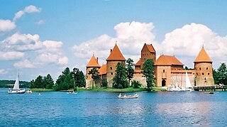
Deutsch: Die Inselburg von Trakai in Litauen
English: Island castle of Trakai, Lituania
Français : Le château-île de Trakai, en Lituanie.
Lietuvių:
Trakai
Polski: Troki
Русский: Тракайский островной замок, Литва.
Türkçe: Trakai Kalesi, Litvanya
|
| Date | |
| Source | own work (photographic film) |
| Author | Julo |
| Camera location |
| View this and other nearby images on: OpenStreetMap |
|
|---|
Licensing
I, the copyright holder of this work, hereby publish it under the following licenses:

|
Permission is granted to copy, distribute and/or modify this document under the terms of the GNU Free Documentation License, Version 1.2 or any later version published by the Free Software Foundation; with no Invariant Sections, no Front-Cover Texts, and no Back-Cover Texts. A copy of the license is included in the section entitled GNU Free Documentation License. |
| This file is licensed under the Creative Commons Attribution-Share Alike 3.0 Unported license. | ||
| ||
| This licensing tag was added to this file as part of the GFDL licensing update. |
You may select the license of your choice.
|
File history
Click on a date/time to view the file as it appeared at that time.
| Date/Time | Thumbnail | Dimensions | User | Comment | |
|---|---|---|---|---|---|
| current | 22:28, 24 March 2018 |
| 988 × 554 (429 KB) | Jacek Halicki | tilt |
| 10:48, 22 February 2011 |
 | 1,006 × 554 (315 KB) | Wuhazet | frame straightening, exposure compensation | |
| 11:32, 18 May 2005 |
 | 1,022 × 582 (428 KB) | Julo | the best version, corrected by Blueshade | |
| 12:29, 17 May 2005 |
 | 1,022 × 655 (531 KB) | Julo | better version | |
| 23:01, 8 February 2005 |
 | 1,019 × 630 (74 KB) | Julo | Trakai(lt) / Troki (pl) - the castle |
File usage
The following pages on the English Wikipedia use this file (pages on other projects are not listed):
Global file usage
The following other wikis use this file:
- Usage on af.wikipedia.org
- Usage on an.wikipedia.org
- Usage on ast.wikipedia.org
- Usage on azb.wikipedia.org
- Usage on az.wikipedia.org
- Usage on be-tarask.wikipedia.org
- Usage on be.wikipedia.org
- Usage on bg.wikipedia.org
- Usage on bs.wikipedia.org
- Usage on ca.wikipedia.org
- Usage on cs.wikipedia.org
- Usage on cv.wikipedia.org
- Usage on da.wikipedia.org
- Usage on de.wikipedia.org
- Usage on dsb.wikipedia.org
- Usage on el.wikipedia.org
- Usage on en.wikivoyage.org
- Usage on eo.wikipedia.org
- Usage on es.wikipedia.org
- Usage on et.wikipedia.org
- Usage on fa.wikipedia.org
- Usage on fi.wikipedia.org
- Usage on fr.wikipedia.org
View more global usage of this file.
Metadata
Size of this preview:
800 × 449 pixels. Other resolutions:
320 × 179 pixels |
640 × 359 pixels |
988 × 554 pixels.
Original file (988 × 554 pixels, file size: 429 KB, MIME type: image/jpeg)
| This is a file from the
Wikimedia Commons. Information from its
description page there is shown below. Commons is a freely licensed media file repository. You can help. |
Summary
| Description |
Deutsch: Die Inselburg von Trakai in Litauen
English: Island castle of Trakai, Lituania
Français : Le château-île de Trakai, en Lituanie.
Lietuvių:
Trakai
Polski: Troki
Русский: Тракайский островной замок, Литва.
Türkçe: Trakai Kalesi, Litvanya
|
| Date | |
| Source | own work (photographic film) |
| Author | Julo |
| Camera location |
| View this and other nearby images on: OpenStreetMap |
|
|---|
Licensing
I, the copyright holder of this work, hereby publish it under the following licenses:
|
|
Permission is granted to copy, distribute and/or modify this document under the terms of the GNU Free Documentation License, Version 1.2 or any later version published by the Free Software Foundation; with no Invariant Sections, no Front-Cover Texts, and no Back-Cover Texts. A copy of the license is included in the section entitled GNU Free Documentation License. |
| This file is licensed under the Creative Commons Attribution-Share Alike 3.0 Unported license. | ||
| ||
| This licensing tag was added to this file as part of the GFDL licensing update. |
You may select the license of your choice.
|
File history
Click on a date/time to view the file as it appeared at that time.
| Date/Time | Thumbnail | Dimensions | User | Comment | |
|---|---|---|---|---|---|
| current | 22:28, 24 March 2018 |
| 988 × 554 (429 KB) | Jacek Halicki | tilt |
| 10:48, 22 February 2011 |
| 1,006 × 554 (315 KB) | Wuhazet | frame straightening, exposure compensation | |
| 11:32, 18 May 2005 |
| 1,022 × 582 (428 KB) | Julo | the best version, corrected by Blueshade | |
| 12:29, 17 May 2005 |
| 1,022 × 655 (531 KB) | Julo | better version | |
| 23:01, 8 February 2005 |
| 1,019 × 630 (74 KB) | Julo | Trakai(lt) / Troki (pl) - the castle |
File usage
The following pages on the English Wikipedia use this file (pages on other projects are not listed):
Global file usage
The following other wikis use this file:
- Usage on af.wikipedia.org
- Usage on an.wikipedia.org
- Usage on ast.wikipedia.org
- Usage on azb.wikipedia.org
- Usage on az.wikipedia.org
- Usage on be-tarask.wikipedia.org
- Usage on be.wikipedia.org
- Usage on bg.wikipedia.org
- Usage on bs.wikipedia.org
- Usage on ca.wikipedia.org
- Usage on cs.wikipedia.org
- Usage on cv.wikipedia.org
- Usage on da.wikipedia.org
- Usage on de.wikipedia.org
- Usage on dsb.wikipedia.org
- Usage on el.wikipedia.org
- Usage on en.wikivoyage.org
- Usage on eo.wikipedia.org
- Usage on es.wikipedia.org
- Usage on et.wikipedia.org
- Usage on fa.wikipedia.org
- Usage on fi.wikipedia.org
- Usage on fr.wikipedia.org
View more global usage of this file.