Photos • Location


Size of this preview:
450 × 600 pixels. Other resolutions:
180 × 240 pixels |
360 × 480 pixels |
576 × 768 pixels |
768 × 1,024 pixels |
2,235 × 2,978 pixels.
Original file (2,235 × 2,978 pixels, file size: 1.33 MB, MIME type: image/jpeg)
| This is a file from the
Wikimedia Commons. Information from its
description page there is shown below. Commons is a freely licensed media file repository. You can help. |
.jpg)
Summary
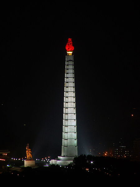
| Description | The Tower of Juche Idea was completed in 1982 to commemorate Kim Il Sung's 70th birthday. The Juche Idea, the official state ideology, developed by the man himself, is a blend of Marxism-Leninism and Autarky. |
| Date | |
| Source | Tower of Juche Idea, Pyongyang, North Korea |
| Author | yeowatzup |
| Camera location |
| View this and other nearby images on: OpenStreetMap |
|
|---|
.jpg¶ms=038.999408_N_0125.751485_E_globe:Earth_type:camera_source:Flickr_&language=en)
Licensing

|
Legal disclaimer This image contains a symbol prohibited by law in some nations, owing to it being a representation of communism, socialism, or a similar governmental structure; or of an associated political party/organization:
Imagery covered may include the hammer and sickle en, red star, emblems/insignias, flags or images of leaders. |
This file is licensed under the
Creative Commons
Attribution 2.0 Generic license.
- You are free:
- to share – to copy, distribute and transmit the work
- to remix – to adapt the work
- Under the following conditions:
- attribution – You must give appropriate credit, provide a link to the license, and indicate if changes were made. You may do so in any reasonable manner, but not in any way that suggests the licensor endorses you or your use.
| This image, originally posted to Flickr, was reviewed on 8 February 2013 by the administrator or reviewer File Upload Bot (Magnus Manske), who confirmed that it was available on Flickr under the stated license on that date. |
File history
Click on a date/time to view the file as it appeared at that time.
| Date/Time | Thumbnail | Dimensions | User | Comment | |
|---|---|---|---|---|---|
| current | 12:59, 8 February 2013 |
| 2,235 × 2,978 (1.33 MB) | File Upload Bot (Magnus Manske) | Transferred from Flickr by User:russavia |
File usage
The following pages on the English Wikipedia use this file (pages on other projects are not listed):
Global file usage
The following other wikis use this file:
- Usage on af.wikipedia.org
- Usage on az.wikipedia.org
- Usage on bn.wikipedia.org
- Usage on eo.wikipedia.org
- Usage on fi.wikipedia.org
- Usage on he.wikipedia.org
- Usage on hu.wikipedia.org
- Usage on id.wikipedia.org
- Usage on ka.wikipedia.org
- Usage on km.wikipedia.org
- Usage on ko.wikipedia.org
- Usage on pt.wikipedia.org
- Usage on ru.wikipedia.org
- Usage on sh.wikipedia.org
- Usage on sv.wikipedia.org
- Usage on th.wikipedia.org
- Usage on tl.wikipedia.org
- Usage on vi.wikipedia.org
- Usage on zh.wikipedia.org
Metadata
.jpg)
Size of this preview:
450 × 600 pixels. Other resolutions:
180 × 240 pixels |
360 × 480 pixels |
576 × 768 pixels |
768 × 1,024 pixels |
2,235 × 2,978 pixels.
Original file (2,235 × 2,978 pixels, file size: 1.33 MB, MIME type: image/jpeg)
| This is a file from the
Wikimedia Commons. Information from its
description page there is shown below. Commons is a freely licensed media file repository. You can help. |
Summary
| Description | The Tower of Juche Idea was completed in 1982 to commemorate Kim Il Sung's 70th birthday. The Juche Idea, the official state ideology, developed by the man himself, is a blend of Marxism-Leninism and Autarky. |
| Date | |
| Source | Tower of Juche Idea, Pyongyang, North Korea |
| Author | yeowatzup |
| Camera location |
| View this and other nearby images on: OpenStreetMap |
|
|---|
Licensing
|
|
Legal disclaimer This image contains a symbol prohibited by law in some nations, owing to it being a representation of communism, socialism, or a similar governmental structure; or of an associated political party/organization:
Imagery covered may include the hammer and sickle en, red star, emblems/insignias, flags or images of leaders. |
This file is licensed under the
Creative Commons
Attribution 2.0 Generic license.
- You are free:
- to share – to copy, distribute and transmit the work
- to remix – to adapt the work
- Under the following conditions:
- attribution – You must give appropriate credit, provide a link to the license, and indicate if changes were made. You may do so in any reasonable manner, but not in any way that suggests the licensor endorses you or your use.
| This image, originally posted to Flickr, was reviewed on 8 February 2013 by the administrator or reviewer File Upload Bot (Magnus Manske), who confirmed that it was available on Flickr under the stated license on that date. |
File history
Click on a date/time to view the file as it appeared at that time.
| Date/Time | Thumbnail | Dimensions | User | Comment | |
|---|---|---|---|---|---|
| current | 12:59, 8 February 2013 |
| 2,235 × 2,978 (1.33 MB) | File Upload Bot (Magnus Manske) | Transferred from Flickr by User:russavia |
File usage
The following pages on the English Wikipedia use this file (pages on other projects are not listed):
Global file usage
The following other wikis use this file:
- Usage on af.wikipedia.org
- Usage on az.wikipedia.org
- Usage on bn.wikipedia.org
- Usage on eo.wikipedia.org
- Usage on fi.wikipedia.org
- Usage on he.wikipedia.org
- Usage on hu.wikipedia.org
- Usage on id.wikipedia.org
- Usage on ka.wikipedia.org
- Usage on km.wikipedia.org
- Usage on ko.wikipedia.org
- Usage on pt.wikipedia.org
- Usage on ru.wikipedia.org
- Usage on sh.wikipedia.org
- Usage on sv.wikipedia.org
- Usage on th.wikipedia.org
- Usage on tl.wikipedia.org
- Usage on vi.wikipedia.org
- Usage on zh.wikipedia.org