Photos • Location


Size of this preview:
399 × 599 pixels. Other resolutions:
160 × 240 pixels |
320 × 480 pixels |
512 × 768 pixels |
682 × 1,024 pixels |
1,365 × 2,048 pixels.
Original file (1,365 × 2,048 pixels, file size: 221 KB, MIME type: image/jpeg)
| This is a file from the
Wikimedia Commons. Information from its
description page there is shown below. Commons is a freely licensed media file repository. You can help. |
Summary
| Description |
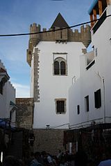
English: Tower in the medina of Asilah, Morocco |
| Date | |
| Source | https://www.flickr.com/photos/peterlozano/2777967264/ |
| Author | Pedro Lozano |
| Camera location |
| View this and other nearby images on: OpenStreetMap |
|
|---|
Licensing
| This image was originally posted to Flickr. Its license was verified as "cc-by-2.0" by the UploadWizard Extension at the time it was transferred to Commons. See the license information for further details. |
This file is licensed under the
Creative Commons
Attribution 2.0 Generic license.
- You are free:
- to share – to copy, distribute and transmit the work
- to remix – to adapt the work
- Under the following conditions:
- attribution – You must give appropriate credit, provide a link to the license, and indicate if changes were made. You may do so in any reasonable manner, but not in any way that suggests the licensor endorses you or your use.
File history
Click on a date/time to view the file as it appeared at that time.
| Date/Time | Thumbnail | Dimensions | User | Comment | |
|---|---|---|---|---|---|
| current | 18:49, 22 February 2013 |
| 1,365 × 2,048 (221 KB) | Ecemaml | User created page with UploadWizard |
File usage
The following pages on the English Wikipedia use this file (pages on other projects are not listed):
Global file usage
The following other wikis use this file:
- Usage on ar.wikipedia.org
- Usage on pt.wikipedia.org
Metadata
Size of this preview:
399 × 599 pixels. Other resolutions:
160 × 240 pixels |
320 × 480 pixels |
512 × 768 pixels |
682 × 1,024 pixels |
1,365 × 2,048 pixels.
Original file (1,365 × 2,048 pixels, file size: 221 KB, MIME type: image/jpeg)
| This is a file from the
Wikimedia Commons. Information from its
description page there is shown below. Commons is a freely licensed media file repository. You can help. |
Summary
| Description |
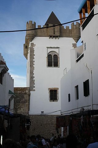
English: Tower in the medina of Asilah, Morocco |
| Date | |
| Source | https://www.flickr.com/photos/peterlozano/2777967264/ |
| Author | Pedro Lozano |
| Camera location |
| View this and other nearby images on: OpenStreetMap |
|
|---|
Licensing
| This image was originally posted to Flickr. Its license was verified as "cc-by-2.0" by the UploadWizard Extension at the time it was transferred to Commons. See the license information for further details. |
This file is licensed under the
Creative Commons
Attribution 2.0 Generic license.
- You are free:
- to share – to copy, distribute and transmit the work
- to remix – to adapt the work
- Under the following conditions:
- attribution – You must give appropriate credit, provide a link to the license, and indicate if changes were made. You may do so in any reasonable manner, but not in any way that suggests the licensor endorses you or your use.
File history
Click on a date/time to view the file as it appeared at that time.
| Date/Time | Thumbnail | Dimensions | User | Comment | |
|---|---|---|---|---|---|
| current | 18:49, 22 February 2013 |
| 1,365 × 2,048 (221 KB) | Ecemaml | User created page with UploadWizard |
File usage
The following pages on the English Wikipedia use this file (pages on other projects are not listed):
Global file usage
The following other wikis use this file:
- Usage on ar.wikipedia.org
- Usage on pt.wikipedia.org