
Size of this PNG preview of this SVG file:
424 × 600 pixels. Other resolutions:
170 × 240 pixels |
339 × 480 pixels |
543 × 768 pixels |
724 × 1,024 pixels |
1,448 × 2,048 pixels |
744 × 1,052 pixels.
Original file (SVG file, nominally 744 × 1,052 pixels, file size: 183 KB)
| This is a file from the
Wikimedia Commons. Information from its
description page there is shown below. Commons is a freely licensed media file repository. You can help. |
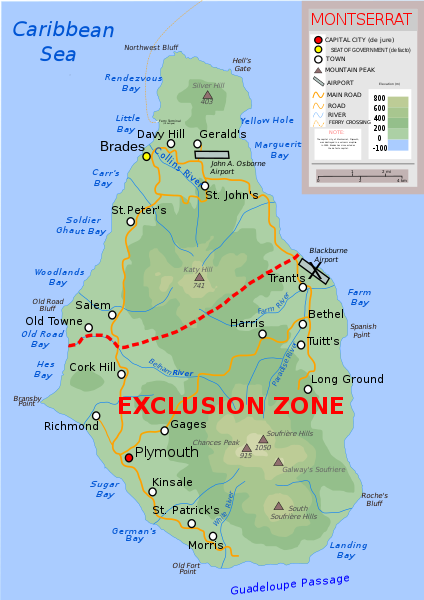
| Description | Topographic map of Montserrat in English |
| Date | |
| Source | Own work |
| Author | Ivan25 |
| Other versions |
Derivative works of this file: |
| SVG development |


| I, the copyright holder of this work, release this work into the
public domain. This applies worldwide. In some countries this may not be legally possible; if so: I grant anyone the right to use this work for any purpose, without any conditions, unless such conditions are required by law. |
File history
Click on a date/time to view the file as it appeared at that time.
| Date/Time | Thumbnail | Dimensions | User | Comment | |
|---|---|---|---|---|---|
| current | 09:00, 11 September 2022 |
| 744 × 1,052 (183 KB) | KajenCAT | File uploaded using svgtranslate tool (https://svgtranslate.toolforge.org/). Added translation for ca. |
| 19:46, 10 September 2022 |
 | 744 × 1,052 (178 KB) | KajenCAT | File uploaded using svgtranslate tool (https://svgtranslate.toolforge.org/). Added translation for ca. | |
| 19:46, 10 September 2022 |
 | 744 × 1,052 (178 KB) | KajenCAT | File uploaded using svgtranslate tool (https://svgtranslate.toolforge.org/). Added translation for ca. | |
| 19:45, 10 September 2022 |
 | 744 × 1,052 (177 KB) | KajenCAT | File uploaded using svgtranslate tool (https://svgtranslate.toolforge.org/). Added translation for ca. | |
| 19:42, 30 August 2022 |
 | 744 × 1,052 (163 KB) | HapHaxion | fix missing note | |
| 19:37, 30 August 2022 |
 | 744 × 1,052 (162 KB) | HapHaxion | reduce file size | |
| 12:08, 6 April 2017 |
 | 744 × 1,052 (264 KB) | RaviC | + Ferry | |
| 19:49, 13 June 2011 |
 | 744 × 1,052 (260 KB) | Kmusser | additions copied from German version | |
| 15:51, 19 April 2011 |
 | 744 × 1,052 (250 KB) | Grandiose | Fix scale, which was clearly incorrect. | |
| 14:39, 16 July 2010 |
 | 744 × 1,052 (250 KB) | Ivan25 | further changes: added new capital, legend changed, water color equalized. |
File usage
The following pages on the English Wikipedia use this file (pages on other projects are not listed):
Global file usage
The following other wikis use this file:
- Usage on ca.wikipedia.org
- Usage on cs.wikipedia.org
- Usage on da.wikipedia.org
- Usage on de.wikipedia.org
- Usage on fa.wikipedia.org
- Usage on fr.wikipedia.org
- Usage on ga.wikipedia.org
- Usage on gl.wikipedia.org
- Usage on id.wikipedia.org
- Usage on li.wikipedia.org
- Usage on lt.wikipedia.org
- Usage on ml.wikipedia.org
- Usage on mt.wikipedia.org
- Usage on nl.wikipedia.org
- Usage on nn.wikipedia.org
- Usage on no.wikipedia.org
- Usage on pap.wikipedia.org
- Usage on pa.wikipedia.org
- Usage on pcd.wikipedia.org
- Usage on shn.wikipedia.org
- Usage on sq.wikipedia.org
- Usage on su.wikipedia.org
- Usage on ta.wikipedia.org
- Usage on tr.wikipedia.org
- Usage on tt.wikipedia.org
- Usage on uk.wikipedia.org
- Usage on vi.wikipedia.org
- Usage on www.wikidata.org
- Usage on yo.wikipedia.org
- Usage on zh.wikipedia.org
Metadata
Size of this PNG preview of this SVG file:
424 × 600 pixels. Other resolutions:
170 × 240 pixels |
339 × 480 pixels |
543 × 768 pixels |
724 × 1,024 pixels |
1,448 × 2,048 pixels |
744 × 1,052 pixels.
Original file (SVG file, nominally 744 × 1,052 pixels, file size: 183 KB)
| This is a file from the
Wikimedia Commons. Information from its
description page there is shown below. Commons is a freely licensed media file repository. You can help. |
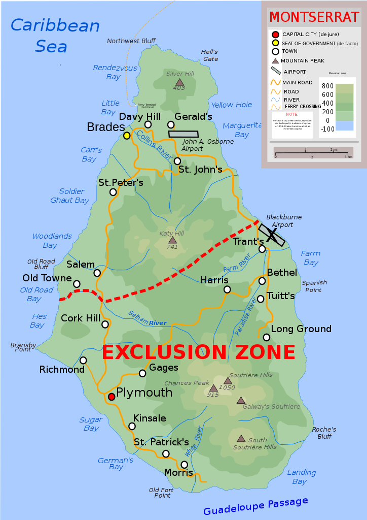
| Description | Topographic map of Montserrat in English |
| Date | |
| Source | Own work |
| Author | Ivan25 |
| Other versions |
Derivative works of this file: |
| SVG development |
| I, the copyright holder of this work, release this work into the
public domain. This applies worldwide. In some countries this may not be legally possible; if so: I grant anyone the right to use this work for any purpose, without any conditions, unless such conditions are required by law. |
File history
Click on a date/time to view the file as it appeared at that time.
| Date/Time | Thumbnail | Dimensions | User | Comment | |
|---|---|---|---|---|---|
| current | 09:00, 11 September 2022 |
| 744 × 1,052 (183 KB) | KajenCAT | File uploaded using svgtranslate tool (https://svgtranslate.toolforge.org/). Added translation for ca. |
| 19:46, 10 September 2022 |
| 744 × 1,052 (178 KB) | KajenCAT | File uploaded using svgtranslate tool (https://svgtranslate.toolforge.org/). Added translation for ca. | |
| 19:46, 10 September 2022 |
| 744 × 1,052 (178 KB) | KajenCAT | File uploaded using svgtranslate tool (https://svgtranslate.toolforge.org/). Added translation for ca. | |
| 19:45, 10 September 2022 |
| 744 × 1,052 (177 KB) | KajenCAT | File uploaded using svgtranslate tool (https://svgtranslate.toolforge.org/). Added translation for ca. | |
| 19:42, 30 August 2022 |
| 744 × 1,052 (163 KB) | HapHaxion | fix missing note | |
| 19:37, 30 August 2022 |
| 744 × 1,052 (162 KB) | HapHaxion | reduce file size | |
| 12:08, 6 April 2017 |
| 744 × 1,052 (264 KB) | RaviC | + Ferry | |
| 19:49, 13 June 2011 |
| 744 × 1,052 (260 KB) | Kmusser | additions copied from German version | |
| 15:51, 19 April 2011 |
| 744 × 1,052 (250 KB) | Grandiose | Fix scale, which was clearly incorrect. | |
| 14:39, 16 July 2010 |
| 744 × 1,052 (250 KB) | Ivan25 | further changes: added new capital, legend changed, water color equalized. |
File usage
The following pages on the English Wikipedia use this file (pages on other projects are not listed):
Global file usage
The following other wikis use this file:
- Usage on ca.wikipedia.org
- Usage on cs.wikipedia.org
- Usage on da.wikipedia.org
- Usage on de.wikipedia.org
- Usage on fa.wikipedia.org
- Usage on fr.wikipedia.org
- Usage on ga.wikipedia.org
- Usage on gl.wikipedia.org
- Usage on id.wikipedia.org
- Usage on li.wikipedia.org
- Usage on lt.wikipedia.org
- Usage on ml.wikipedia.org
- Usage on mt.wikipedia.org
- Usage on nl.wikipedia.org
- Usage on nn.wikipedia.org
- Usage on no.wikipedia.org
- Usage on pap.wikipedia.org
- Usage on pa.wikipedia.org
- Usage on pcd.wikipedia.org
- Usage on shn.wikipedia.org
- Usage on sq.wikipedia.org
- Usage on su.wikipedia.org
- Usage on ta.wikipedia.org
- Usage on tr.wikipedia.org
- Usage on tt.wikipedia.org
- Usage on uk.wikipedia.org
- Usage on vi.wikipedia.org
- Usage on www.wikidata.org
- Usage on yo.wikipedia.org
- Usage on zh.wikipedia.org