Original file (1,603 × 765 pixels, file size: 1.9 MB, MIME type: image/png)
| This is a file from the
Wikimedia Commons. Information from its
description page there is shown below. Commons is a freely licensed media file repository. You can help. |
Summary

|
This file has been superseded by
The Roman Empire ca. 400 AD.svg. It is recommended to use the other file. Please note that deleting superseded images
requires consent.
|

|
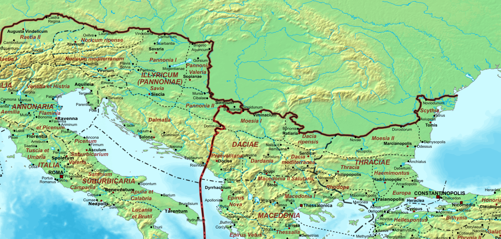
| Description | Map of the Roman Empire ca. 400 AD, showing the administrative division into dioceses and provinces, as well as the major cities. The demarcation between Eastern and Western Empires is noted in red. |
| Date | |
| Source |
Base map found at
User:Koba-chan/Topographic map, otherwise self-made. Data based on maps in atlases (Westermann's Atlas zur Weltgeschichte, the Academy of Athens' History of the Greek Nation, etc.) and the internet and on contemporary sources, primarily the
Notitia Dignitatum and the
Synecdemus. |
| Author | Cplakidas |
| Other versions |
|


.png)
Licensing
| I, the copyright holder of this work, release this work into the
public domain. This applies worldwide. In some countries this may not be legally possible; if so: I grant anyone the right to use this work for any purpose, without any conditions, unless such conditions are required by law. |
| Annotations | This image is annotated: View the annotations at Commons |
File history
Click on a date/time to view the file as it appeared at that time.
| Date/Time | Thumbnail | Dimensions | User | Comment | |
|---|---|---|---|---|---|
| current | 06:45, 30 October 2020 |
| 1,603 × 765 (1.9 MB) | GPinkerton | File:The Roman Empire ca 400 AD.png cropped 63 % horizontally, 72 % vertically using CropTool with lossless mode. |
File usage
Metadata
.png)
Original file (1,603 × 765 pixels, file size: 1.9 MB, MIME type: image/png)
| This is a file from the
Wikimedia Commons. Information from its
description page there is shown below. Commons is a freely licensed media file repository. You can help. |
Summary
|
|
This file has been superseded by
The Roman Empire ca. 400 AD.svg. It is recommended to use the other file. Please note that deleting superseded images
requires consent.
|
|
| Description | Map of the Roman Empire ca. 400 AD, showing the administrative division into dioceses and provinces, as well as the major cities. The demarcation between Eastern and Western Empires is noted in red. |
| Date | |
| Source |
Base map found at
User:Koba-chan/Topographic map, otherwise self-made. Data based on maps in atlases (Westermann's Atlas zur Weltgeschichte, the Academy of Athens' History of the Greek Nation, etc.) and the internet and on contemporary sources, primarily the
Notitia Dignitatum and the
Synecdemus. |
| Author | Cplakidas |
| Other versions |
|
Licensing
| I, the copyright holder of this work, release this work into the
public domain. This applies worldwide. In some countries this may not be legally possible; if so: I grant anyone the right to use this work for any purpose, without any conditions, unless such conditions are required by law. |
| Annotations | This image is annotated: View the annotations at Commons |
File history
Click on a date/time to view the file as it appeared at that time.
| Date/Time | Thumbnail | Dimensions | User | Comment | |
|---|---|---|---|---|---|
| current | 06:45, 30 October 2020 |
| 1,603 × 765 (1.9 MB) | GPinkerton | File:The Roman Empire ca 400 AD.png cropped 63 % horizontally, 72 % vertically using CropTool with lossless mode. |