
Original file (SVG file, nominally 842 × 595 pixels, file size: 110 KB)
| This is a file from the
Wikimedia Commons. Information from its
description page there is shown below. Commons is a freely licensed media file repository. You can help. |
_Map_-en.svg)
Summary
| Description |
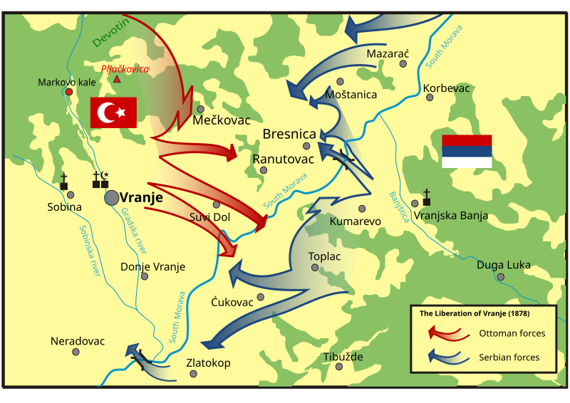
English: The Liberation of Vranje in 1878.
Original author of the map Nemanja Todorović Štiplija who made a map according the one found in Vukanović, Tatomir; "Vranje; Etnička istorija i kulturna baština vranjskog gravitacionog područja u doba oslobođenja od Turaka 2878. godine"; Radnički univerzitet u Vranju, 1978, Page 31. The map in the original language can be found here. |
| Date | |
| Source | Original map found on Wikimedia Commons |
| Author | Nemanja Todorović Štiplija |
Licensing
- You are free:
- to share – to copy, distribute and transmit the work
- to remix – to adapt the work
- Under the following conditions:
- attribution – You must give appropriate credit, provide a link to the license, and indicate if changes were made. You may do so in any reasonable manner, but not in any way that suggests the licensor endorses you or your use.
- share alike – If you remix, transform, or build upon the material, you must distribute your contributions under the same or compatible license as the original.
File history
Click on a date/time to view the file as it appeared at that time.
| Date/Time | Thumbnail | Dimensions | User | Comment | |
|---|---|---|---|---|---|
| current | 05:09, 29 January 2018 |
| 842 × 595 (110 KB) | Serbianboy | User created page with UploadWizard |
File usage
Global file usage
The following other wikis use this file:
- Usage on it.wikipedia.org
- Usage on ka.wikipedia.org
- Usage on mk.wikipedia.org
Metadata
_Map_-en.svg)
Original file (SVG file, nominally 842 × 595 pixels, file size: 110 KB)
| This is a file from the
Wikimedia Commons. Information from its
description page there is shown below. Commons is a freely licensed media file repository. You can help. |
Summary
| Description |
English: The Liberation of Vranje in 1878.
Original author of the map Nemanja Todorović Štiplija who made a map according the one found in Vukanović, Tatomir; "Vranje; Etnička istorija i kulturna baština vranjskog gravitacionog područja u doba oslobođenja od Turaka 2878. godine"; Radnički univerzitet u Vranju, 1978, Page 31. The map in the original language can be found here. |
| Date | |
| Source | Original map found on Wikimedia Commons |
| Author | Nemanja Todorović Štiplija |
Licensing
- You are free:
- to share – to copy, distribute and transmit the work
- to remix – to adapt the work
- Under the following conditions:
- attribution – You must give appropriate credit, provide a link to the license, and indicate if changes were made. You may do so in any reasonable manner, but not in any way that suggests the licensor endorses you or your use.
- share alike – If you remix, transform, or build upon the material, you must distribute your contributions under the same or compatible license as the original.
File history
Click on a date/time to view the file as it appeared at that time.
| Date/Time | Thumbnail | Dimensions | User | Comment | |
|---|---|---|---|---|---|
| current | 05:09, 29 January 2018 |
| 842 × 595 (110 KB) | Serbianboy | User created page with UploadWizard |
File usage
Global file usage
The following other wikis use this file:
- Usage on it.wikipedia.org
- Usage on ka.wikipedia.org
- Usage on mk.wikipedia.org