
Size of this PNG preview of this SVG file:
739 × 600 pixels. Other resolutions:
296 × 240 pixels |
592 × 480 pixels |
947 × 768 pixels |
1,262 × 1,024 pixels |
2,524 × 2,048 pixels |
1,703 × 1,382 pixels.
Original file (SVG file, nominally 1,703 × 1,382 pixels, file size: 6.15 MB)
| This is a file from the
Wikimedia Commons. Information from its
description page there is shown below. Commons is a freely licensed media file repository. You can help. |
Summary
| Description |
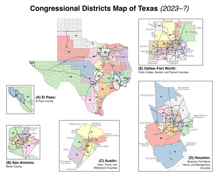
English: Map of the congressional districts of Texas, complemented with counties and primary roads (interstates, state highways, etc.), as well as insets of major metropolitan areas. These congressional districts will be put into effect from 2023 to 2033, following the 2022 US House elections. Among the shapefiles used:
https://data.capitol.texas.gov/dataset/b806b39a-4bab-4103-a66a-9c99bcaba490 (congressional districts, released under CC-BY by the Texas Legislative Council),
https://www2.census.gov/geo/tiger/GENZ2020/shp/cb_2020_us_county_500k.zip and
https://www2.census.gov/geo/tiger/GENZ2020/shp/cb_2020_us_county_within_cd116_500k.zip (counties),
https://www.census.gov/cgi-bin/geo/shapefiles/index.php (roads). Made with
https://mapshaper.org/ (Mercator projection) and Inkscape (Helvetica font). |
| Date | |
| Source | Own work |
| Author | Twotwofourtysix |
Licensing
I, the copyright holder of this work, hereby publish it under the following license:
This file is licensed under the
Creative Commons
Attribution-Share Alike 4.0 International license.
- You are free:
- to share – to copy, distribute and transmit the work
- to remix – to adapt the work
- Under the following conditions:
- attribution – You must give appropriate credit, provide a link to the license, and indicate if changes were made. You may do so in any reasonable manner, but not in any way that suggests the licensor endorses you or your use.
- share alike – If you remix, transform, or build upon the material, you must distribute your contributions under the same or compatible license as the original.
File history
Click on a date/time to view the file as it appeared at that time.
| Date/Time | Thumbnail | Dimensions | User | Comment | |
|---|---|---|---|---|---|
| current | 12:44, 10 September 2022 |
| 1,703 × 1,382 (6.15 MB) | Twotwofourtysix | Uploaded own work with UploadWizard |
File usage
The following pages on the English Wikipedia use this file (pages on other projects are not listed):
Global file usage
The following other wikis use this file:
- Usage on it.wikipedia.org
- Usage on ja.wikipedia.org
- Usage on simple.wikipedia.org
- Usage on zh.wikipedia.org
Metadata
Size of this PNG preview of this SVG file:
739 × 600 pixels. Other resolutions:
296 × 240 pixels |
592 × 480 pixels |
947 × 768 pixels |
1,262 × 1,024 pixels |
2,524 × 2,048 pixels |
1,703 × 1,382 pixels.
Original file (SVG file, nominally 1,703 × 1,382 pixels, file size: 6.15 MB)
| This is a file from the
Wikimedia Commons. Information from its
description page there is shown below. Commons is a freely licensed media file repository. You can help. |
Summary
| Description |
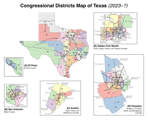
English: Map of the congressional districts of Texas, complemented with counties and primary roads (interstates, state highways, etc.), as well as insets of major metropolitan areas. These congressional districts will be put into effect from 2023 to 2033, following the 2022 US House elections. Among the shapefiles used:
https://data.capitol.texas.gov/dataset/b806b39a-4bab-4103-a66a-9c99bcaba490 (congressional districts, released under CC-BY by the Texas Legislative Council),
https://www2.census.gov/geo/tiger/GENZ2020/shp/cb_2020_us_county_500k.zip and
https://www2.census.gov/geo/tiger/GENZ2020/shp/cb_2020_us_county_within_cd116_500k.zip (counties),
https://www.census.gov/cgi-bin/geo/shapefiles/index.php (roads). Made with
https://mapshaper.org/ (Mercator projection) and Inkscape (Helvetica font). |
| Date | |
| Source | Own work |
| Author | Twotwofourtysix |
Licensing
I, the copyright holder of this work, hereby publish it under the following license:
This file is licensed under the
Creative Commons
Attribution-Share Alike 4.0 International license.
- You are free:
- to share – to copy, distribute and transmit the work
- to remix – to adapt the work
- Under the following conditions:
- attribution – You must give appropriate credit, provide a link to the license, and indicate if changes were made. You may do so in any reasonable manner, but not in any way that suggests the licensor endorses you or your use.
- share alike – If you remix, transform, or build upon the material, you must distribute your contributions under the same or compatible license as the original.
File history
Click on a date/time to view the file as it appeared at that time.
| Date/Time | Thumbnail | Dimensions | User | Comment | |
|---|---|---|---|---|---|
| current | 12:44, 10 September 2022 |
| 1,703 × 1,382 (6.15 MB) | Twotwofourtysix | Uploaded own work with UploadWizard |
File usage
The following pages on the English Wikipedia use this file (pages on other projects are not listed):
Global file usage
The following other wikis use this file:
- Usage on it.wikipedia.org
- Usage on ja.wikipedia.org
- Usage on simple.wikipedia.org
- Usage on zh.wikipedia.org