Size of this preview:
596 × 599 pixels. Other resolutions:
239 × 240 pixels |
477 × 480 pixels |
764 × 768 pixels |
1,018 × 1,024 pixels |
2,037 × 2,048 pixels |
3,940 × 3,962 pixels.
Original file (3,940 × 3,962 pixels, file size: 2.61 MB, MIME type: image/jpeg)
| This is a file from the
Wikimedia Commons. Information from its
description page there is shown below. Commons is a freely licensed media file repository. You can help. |
Summary
| Description |
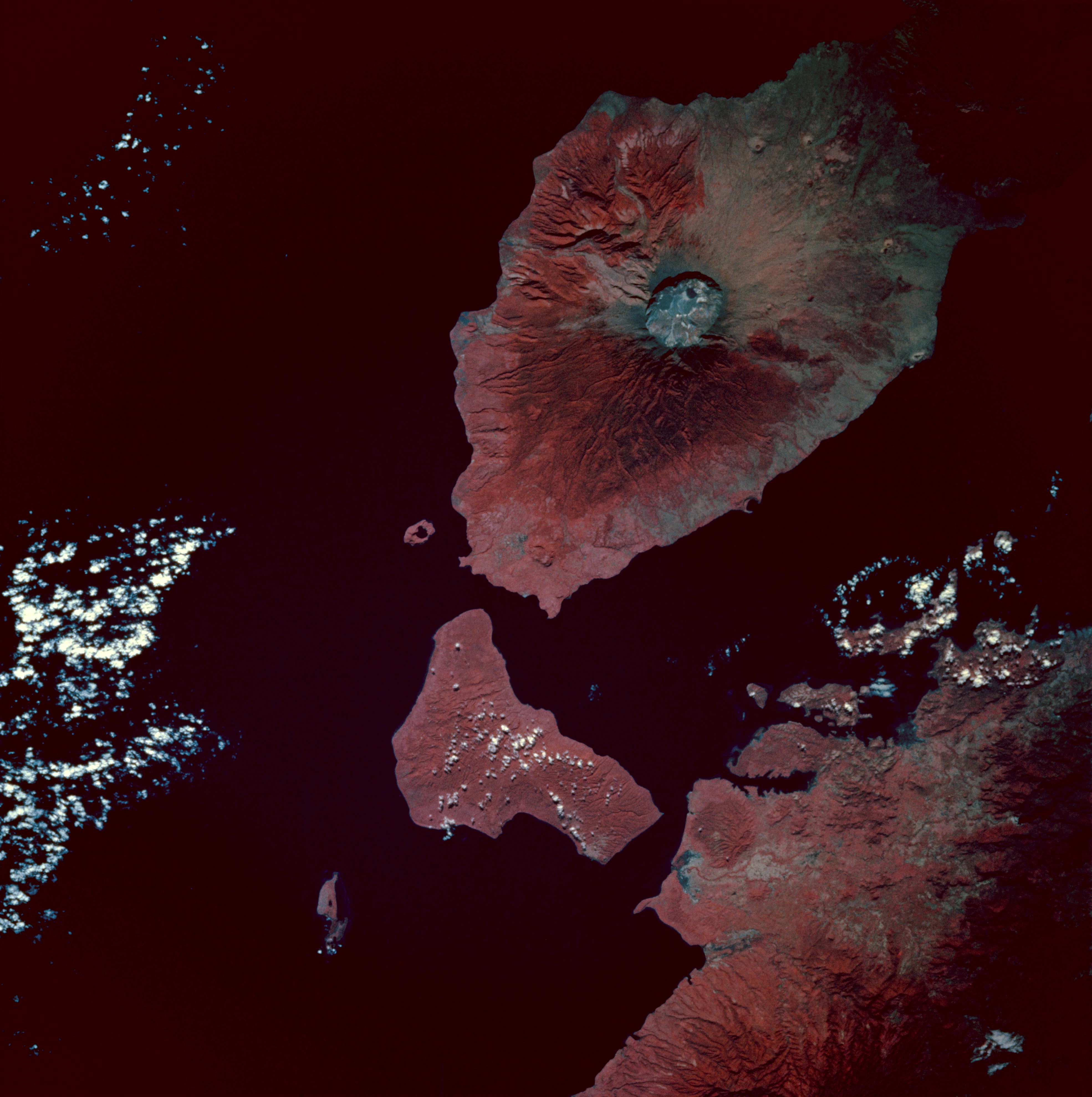
Infrared image of Mount Tambora, Sumbawa Island, Indonesia. Taken from the space shuttle Endeavour at 0:54 GMT on 13 May 1992.
|
| Date | |
| Source | [2] |
| Author | Image Science and Analysis Laboratory, NASA-Johnson Space Center. "The Gateway to Astronaut Photography of Earth". |
Licensing
| This file is in the public domain in the United States because it was solely created by NASA. NASA copyright policy states that "NASA material is not protected by copyright unless noted". (See Template:PD-USGov, NASA copyright policy page or JPL Image Use Policy.) | ||
 |
Warnings:
|
File history
Click on a date/time to view the file as it appeared at that time.
| Date/Time | Thumbnail | Dimensions | User | Comment | |
|---|---|---|---|---|---|
| current | 08:49, 8 February 2010 |
| 3,940 × 3,962 (2.61 MB) | Avenue | {{Information |Description=Infrared image of Mount Tambora, Sumbawa Island, Indonesia. Taken from the space shuttle Endeavour at 0:54 GMT on 13 May 1992. <br/>Description from [http://city.jsc.nasa.gov/sseop/EFS/photoinfo.pl?PHOTO=STS049-97-54]:<br/> The |
File usage
The following pages on the English Wikipedia use this file (pages on other projects are not listed):
Global file usage
The following other wikis use this file:
- Usage on ar.wikipedia.org
- Usage on ast.wikipedia.org
- Usage on bn.wikipedia.org
- Usage on br.wikipedia.org
- Usage on el.wikipedia.org
- Usage on es.wikipedia.org
- Usage on id.wikipedia.org
- Usage on mk.wikipedia.org
- Usage on ms.wikipedia.org
- Usage on pt.wikipedia.org
- Usage on ro.wikipedia.org
- Usage on tr.wikipedia.org
- Tambora Dağı
- 1815 Tambora Dağı patlaması
- Kullanıcı:Anerka/Takip/Biliyor muydunuz?
- Kullanıcı:LostMyMind/BM logları
- Vikipedi:Biliyor muydunuz?/Arşiv/2022+
- Vikipedi:Biliyor muydunuz?/2023-03-05
- Vikipedi:Biliyor muydunuz/Mart 2023
- Vikipedi:Biliyor muydunuz/Şubat 2024
- Vikipedi:Biliyor muydunuz?/2024-02-13
- Usage on zh.wikipedia.org
Metadata
Size of this preview:
596 × 599 pixels. Other resolutions:
239 × 240 pixels |
477 × 480 pixels |
764 × 768 pixels |
1,018 × 1,024 pixels |
2,037 × 2,048 pixels |
3,940 × 3,962 pixels.
Original file (3,940 × 3,962 pixels, file size: 2.61 MB, MIME type: image/jpeg)
| This is a file from the
Wikimedia Commons. Information from its
description page there is shown below. Commons is a freely licensed media file repository. You can help. |
Summary
| Description |
Infrared image of Mount Tambora, Sumbawa Island, Indonesia. Taken from the space shuttle Endeavour at 0:54 GMT on 13 May 1992.
|
| Date | |
| Source | [2] |
| Author | Image Science and Analysis Laboratory, NASA-Johnson Space Center. "The Gateway to Astronaut Photography of Earth". |
Licensing
| This file is in the public domain in the United States because it was solely created by NASA. NASA copyright policy states that "NASA material is not protected by copyright unless noted". (See Template:PD-USGov, NASA copyright policy page or JPL Image Use Policy.) | ||
|
Warnings:
|
File history
Click on a date/time to view the file as it appeared at that time.
| Date/Time | Thumbnail | Dimensions | User | Comment | |
|---|---|---|---|---|---|
| current | 08:49, 8 February 2010 |
| 3,940 × 3,962 (2.61 MB) | Avenue | {{Information |Description=Infrared image of Mount Tambora, Sumbawa Island, Indonesia. Taken from the space shuttle Endeavour at 0:54 GMT on 13 May 1992. <br/>Description from [http://city.jsc.nasa.gov/sseop/EFS/photoinfo.pl?PHOTO=STS049-97-54]:<br/> The |
File usage
The following pages on the English Wikipedia use this file (pages on other projects are not listed):
Global file usage
The following other wikis use this file:
- Usage on ar.wikipedia.org
- Usage on ast.wikipedia.org
- Usage on bn.wikipedia.org
- Usage on br.wikipedia.org
- Usage on el.wikipedia.org
- Usage on es.wikipedia.org
- Usage on id.wikipedia.org
- Usage on mk.wikipedia.org
- Usage on ms.wikipedia.org
- Usage on pt.wikipedia.org
- Usage on ro.wikipedia.org
- Usage on tr.wikipedia.org
- Tambora Dağı
- 1815 Tambora Dağı patlaması
- Kullanıcı:Anerka/Takip/Biliyor muydunuz?
- Kullanıcı:LostMyMind/BM logları
- Vikipedi:Biliyor muydunuz?/Arşiv/2022+
- Vikipedi:Biliyor muydunuz?/2023-03-05
- Vikipedi:Biliyor muydunuz/Mart 2023
- Vikipedi:Biliyor muydunuz/Şubat 2024
- Vikipedi:Biliyor muydunuz?/2024-02-13
- Usage on zh.wikipedia.org