
Size of this preview:
466 × 599 pixels. Other resolutions:
187 × 240 pixels |
373 × 480 pixels |
690 × 887 pixels.
Original file (690 × 887 pixels, file size: 49 KB, MIME type: image/png)
| This is a file from the
Wikimedia Commons. Information from its
description page there is shown below. Commons is a freely licensed media file repository. You can help. |
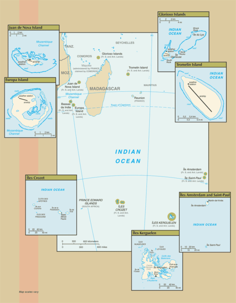
Map of the French Southern and Antarctic Lands, from CIA.gov
This image is in the
public domain because it contains materials that originally came from the United States
Central Intelligence Agency's
World Factbook.
|
 |
File history
Click on a date/time to view the file as it appeared at that time.
| Date/Time | Thumbnail | Dimensions | User | Comment | |
|---|---|---|---|---|---|
| current | 10:14, 25 July 2007 |
| 690 × 887 (49 KB) | Hoshie | Updated map of the French Southern and Antarctic Lands from the CIA World Factbook, 19 July 07 rev. Src: https://www.cia.gov/library/publications/the-world-factbook/maps/fs-map.gif |
| 09:12, 18 January 2006 |
 | 328 × 352 (7 KB) | Hoshie | Map of the French Southern and Antarctic Lands, from [http://www.cia.gov/cia/publications/factbook/maps/fs-map.gif CIA.gov] {{PD-USGov-CIA-WF}} |
File usage
The following pages on the English Wikipedia use this file (pages on other projects are not listed):
Global file usage
The following other wikis use this file:
- Usage on af.wikipedia.org
- Usage on az.wikipedia.org
- Usage on be-tarask.wikipedia.org
- Usage on bn.wikipedia.org
- Usage on ca.wikipedia.org
- Usage on cy.wikipedia.org
- Usage on de.wikipedia.org
- Usage on eo.wikipedia.org
- Usage on es.wikipedia.org
- Usage on frr.wikipedia.org
- Usage on gl.wikipedia.org
- Usage on id.wikipedia.org
- Usage on it.wikipedia.org
- Usage on lv.wikipedia.org
- Usage on mk.wikipedia.org
- Usage on mt.wikipedia.org
- Usage on nds-nl.wikipedia.org
- Usage on nn.wikipedia.org
- Usage on ro.wikipedia.org
- Usage on war.wikipedia.org
- Usage on zh-yue.wikipedia.org
- Usage on zh.wikipedia.org
Size of this preview:
466 × 599 pixels. Other resolutions:
187 × 240 pixels |
373 × 480 pixels |
690 × 887 pixels.
Original file (690 × 887 pixels, file size: 49 KB, MIME type: image/png)
| This is a file from the
Wikimedia Commons. Information from its
description page there is shown below. Commons is a freely licensed media file repository. You can help. |
Map of the French Southern and Antarctic Lands, from CIA.gov
This image is in the
public domain because it contains materials that originally came from the United States
Central Intelligence Agency's
World Factbook.
|
|
File history
Click on a date/time to view the file as it appeared at that time.
| Date/Time | Thumbnail | Dimensions | User | Comment | |
|---|---|---|---|---|---|
| current | 10:14, 25 July 2007 |
| 690 × 887 (49 KB) | Hoshie | Updated map of the French Southern and Antarctic Lands from the CIA World Factbook, 19 July 07 rev. Src: https://www.cia.gov/library/publications/the-world-factbook/maps/fs-map.gif |
| 09:12, 18 January 2006 |
| 328 × 352 (7 KB) | Hoshie | Map of the French Southern and Antarctic Lands, from [http://www.cia.gov/cia/publications/factbook/maps/fs-map.gif CIA.gov] {{PD-USGov-CIA-WF}} |
File usage
The following pages on the English Wikipedia use this file (pages on other projects are not listed):
Global file usage
The following other wikis use this file:
- Usage on af.wikipedia.org
- Usage on az.wikipedia.org
- Usage on be-tarask.wikipedia.org
- Usage on bn.wikipedia.org
- Usage on ca.wikipedia.org
- Usage on cy.wikipedia.org
- Usage on de.wikipedia.org
- Usage on eo.wikipedia.org
- Usage on es.wikipedia.org
- Usage on frr.wikipedia.org
- Usage on gl.wikipedia.org
- Usage on id.wikipedia.org
- Usage on it.wikipedia.org
- Usage on lv.wikipedia.org
- Usage on mk.wikipedia.org
- Usage on mt.wikipedia.org
- Usage on nds-nl.wikipedia.org
- Usage on nn.wikipedia.org
- Usage on ro.wikipedia.org
- Usage on war.wikipedia.org
- Usage on zh-yue.wikipedia.org
- Usage on zh.wikipedia.org