
Original file (SVG file, nominally 922 × 762 pixels, file size: 3.56 MB)
| This is a file from the
Wikimedia Commons. Information from its
description page there is shown below. Commons is a freely licensed media file repository. You can help. |
.svg)
Summary
| Description |
English: Detailed map of Syria showing the approximate frontlines during late-November 2023. Citing
Al Jazeera.
|
||
| Date | |||
| Source |
Derivate of Syrian Civil War map (September 10 2021).svg by Rr016.
|
||
| Author | Ecrusized | ||
| Other versions | If you want to see the history of the Syrian Civil War before 2020, look at Syrian Civil War map.svg |
.svg)
Licensing
- You are free:
- to share – to copy, distribute and transmit the work
- to remix – to adapt the work
- Under the following conditions:
- attribution – You must give appropriate credit, provide a link to the license, and indicate if changes were made. You may do so in any reasonable manner, but not in any way that suggests the licensor endorses you or your use.
- share alike – If you remix, transform, or build upon the material, you must distribute your contributions under the same or compatible license as the original.
File history
Click on a date/time to view the file as it appeared at that time.
| Date/Time | Thumbnail | Dimensions | User | Comment | |
|---|---|---|---|---|---|
| current | 16:37, 24 November 2023 |
| 922 × 762 (3.56 MB) | Ecrusized | Uploaded own work with UploadWizard |
File usage
The following file is a duplicate of this file ( more details):
.svg)
- File:Syrian Civil War map.svg from Commons
- Al-Nusra Front
- Autonomous Administration of North and East Syria
- Bashar al-Assad
- Belligerents in the Syrian civil war
- Federalization of Syria
- Freedom of religion in Asia by country
- History of Syria
- History of al-Qaeda
- Islamic State
- Rojava–Islamist conflict
- Russian intervention in the Syrian civil war
- Sectarianism and minorities in the Syrian civil war
- Syria
- Syrian civil war
- Syrian opposition
- Timeline of US intervention in the Syrian civil war
- Turkey–Islamic State conflict
- US intervention in the Syrian civil war
- Talk:Autonomous Administration of North and East Syria/Archive 2
- Talk:List of ongoing armed conflicts
- User:Oscar666kta420swag/sandbox
- Wikipedia:WikiProject Syria
- Wikipedia:WikiProject Syria/Topic
- Template:Syrian Civil War map
- Template:Syrian civil war infobox
- Template:Syrian civil war infobox/sandbox
- Template:Syrian civil war infobox/testcases
Global file usage
The following other wikis use this file:
- Usage on af.wikipedia.org
- Usage on ar.wikipedia.org
- Usage on ary.wikipedia.org
- Usage on arz.wikipedia.org
- Usage on ast.wikipedia.org
- Usage on azb.wikipedia.org
- Usage on az.wikipedia.org
- Usage on ba.wikipedia.org
- Usage on be-tarask.wikipedia.org
- Usage on be.wikipedia.org
- Usage on bg.wikipedia.org
- Usage on bn.wikipedia.org
- Usage on br.wikipedia.org
- Usage on bs.wikipedia.org
- Usage on ca.wikipedia.org
- Usage on ckb.wikipedia.org
- Usage on cs.wikipedia.org
- Usage on cy.wikipedia.org
- Usage on de.wikipedia.org
- Usage on el.wikipedia.org
View more global usage of this file.
.svg)
Metadata
.svg)
Original file (SVG file, nominally 922 × 762 pixels, file size: 3.56 MB)
| This is a file from the
Wikimedia Commons. Information from its
description page there is shown below. Commons is a freely licensed media file repository. You can help. |
Summary
| Description |
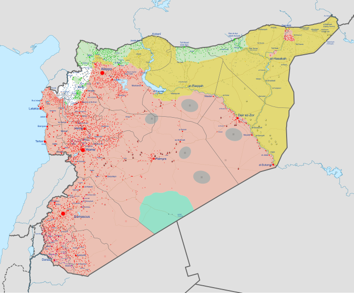
English: Detailed map of Syria showing the approximate frontlines during late-November 2023. Citing
Al Jazeera.
|
||
| Date | |||
| Source |
Derivate of Syrian Civil War map (September 10 2021).svg by Rr016.
|
||
| Author | Ecrusized | ||
| Other versions | If you want to see the history of the Syrian Civil War before 2020, look at Syrian Civil War map.svg |
Licensing
- You are free:
- to share – to copy, distribute and transmit the work
- to remix – to adapt the work
- Under the following conditions:
- attribution – You must give appropriate credit, provide a link to the license, and indicate if changes were made. You may do so in any reasonable manner, but not in any way that suggests the licensor endorses you or your use.
- share alike – If you remix, transform, or build upon the material, you must distribute your contributions under the same or compatible license as the original.
File history
Click on a date/time to view the file as it appeared at that time.
| Date/Time | Thumbnail | Dimensions | User | Comment | |
|---|---|---|---|---|---|
| current | 16:37, 24 November 2023 |
| 922 × 762 (3.56 MB) | Ecrusized | Uploaded own work with UploadWizard |
File usage
The following file is a duplicate of this file ( more details):
- File:Syrian Civil War map.svg from Commons
- Al-Nusra Front
- Autonomous Administration of North and East Syria
- Bashar al-Assad
- Belligerents in the Syrian civil war
- Federalization of Syria
- Freedom of religion in Asia by country
- History of Syria
- History of al-Qaeda
- Islamic State
- Rojava–Islamist conflict
- Russian intervention in the Syrian civil war
- Sectarianism and minorities in the Syrian civil war
- Syria
- Syrian civil war
- Syrian opposition
- Timeline of US intervention in the Syrian civil war
- Turkey–Islamic State conflict
- US intervention in the Syrian civil war
- Talk:Autonomous Administration of North and East Syria/Archive 2
- Talk:List of ongoing armed conflicts
- User:Oscar666kta420swag/sandbox
- Wikipedia:WikiProject Syria
- Wikipedia:WikiProject Syria/Topic
- Template:Syrian Civil War map
- Template:Syrian civil war infobox
- Template:Syrian civil war infobox/sandbox
- Template:Syrian civil war infobox/testcases
Global file usage
The following other wikis use this file:
- Usage on af.wikipedia.org
- Usage on ar.wikipedia.org
- Usage on ary.wikipedia.org
- Usage on arz.wikipedia.org
- Usage on ast.wikipedia.org
- Usage on azb.wikipedia.org
- Usage on az.wikipedia.org
- Usage on ba.wikipedia.org
- Usage on be-tarask.wikipedia.org
- Usage on be.wikipedia.org
- Usage on bg.wikipedia.org
- Usage on bn.wikipedia.org
- Usage on br.wikipedia.org
- Usage on bs.wikipedia.org
- Usage on ca.wikipedia.org
- Usage on ckb.wikipedia.org
- Usage on cs.wikipedia.org
- Usage on cy.wikipedia.org
- Usage on de.wikipedia.org
- Usage on el.wikipedia.org
View more global usage of this file.