
Original file (SVG file, nominally 1,123 × 794 pixels, file size: 178 KB)
| This is a file from the
Wikimedia Commons. Information from its
description page there is shown below. Commons is a freely licensed media file repository. You can help. |
Summary
| Description |
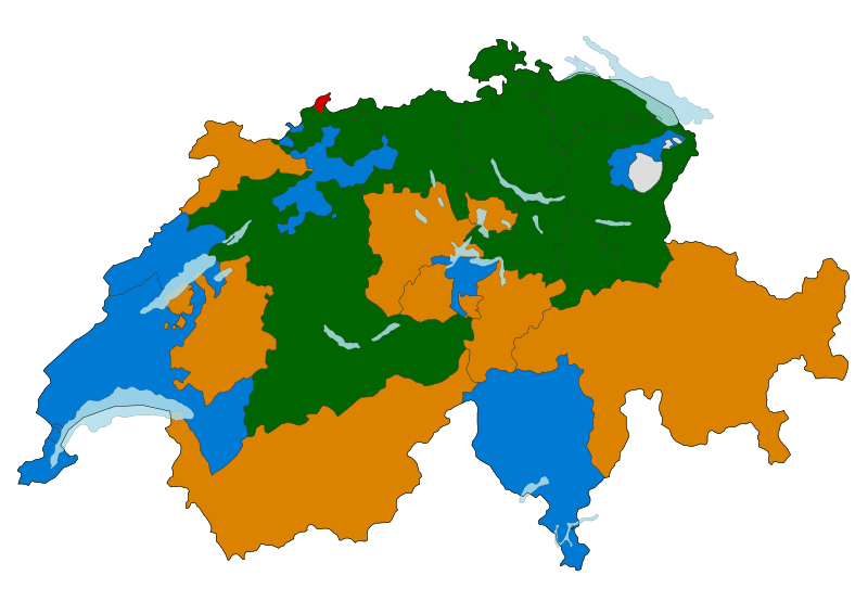
Map of the cantons of Switzerland, with the cantons shaded by the largest party in each cantonal parliament. Correct as of 4 december, 2018. Christian Democratic People's Party (CVP/PDC)
Swiss People's Party (SVP/UDC)
FDP.The Liberals (FDP/PLR)
Social Democratic Party (SP/PS)
Colours are the standardised colours used on English Wikipedia. The figures for the FDP include combining both FDP and Liberal Party contingents where they coexist (otherwise, Vaud would be SP/PS). |
| Date | (UTC) |
| Source | |
| Author |
|
| SVG development |
Licensing
- You are free:
- to share – to copy, distribute and transmit the work
- to remix – to adapt the work
- Under the following conditions:
- attribution – You must give appropriate credit, provide a link to the license, and indicate if changes were made. You may do so in any reasonable manner, but not in any way that suggests the licensor endorses you or your use.
- share alike – If you remix, transform, or build upon the material, you must distribute your contributions under the same or compatible license as the original.

|
Permission is granted to copy, distribute and/or modify this document under the terms of the GNU Free Documentation License, Version 1.2 or any later version published by the Free Software Foundation; with no Invariant Sections, no Front-Cover Texts, and no Back-Cover Texts. A copy of the license is included in the section entitled GNU Free Documentation License. |
Original upload log
This image is a derivative work of the following images:
-
File:Suisse cantons.svg licensed with Cc-by-sa-3.0,2.5,2.0,1.0, GFDL
- 2008-10-10T16:50:42Z Pymouss 1052x744 (583858 Bytes) {{Information |Description={{de|[[:de:Kanton (Schweiz)|Kantone der Schweiz]]}} {{fr|[[:fr:Cantons suisses|Cantons de la Suisse]]}} {{it|[[:it:Cantoni della Svizzera|Cantoni della Svizzera]]}} {{rm|Chantuns da la [[:rm:Svizra|
Uploaded with derivativeFX
File history
Click on a date/time to view the file as it appeared at that time.
| Date/Time | Thumbnail | Dimensions | User | Comment | |
|---|---|---|---|---|---|
| current | 16:55, 8 March 2023 |
| 1,123 × 794 (178 KB) | Gbuvn | update BL |
| 23:50, 15 March 2022 |
 | 1,123 × 794 (178 KB) | Gbuvn | updated FR | |
| 09:45, 5 July 2021 |
 | 1,123 × 794 (178 KB) | Ngagnebin | PBD & PDC have merged into The Center on a cantonal scale in Grisons on 7 June 2021 thus making it the biggest party. This new map has former incorrect boundaries re-drawn : correction of wrong boundaries of South-West exclave (Buchberg and Rüdlingen) of Canton of Schaffhausen, thus correction of the North of Bülach District's wrong boundaries as well for the Canton of Zurich. | |
| 23:36, 8 April 2019 |
 | 1,052 × 744 (258 KB) | Ngagnebin | I made a mistake for NW : PLR/FDP is the first party in the Canton. | |
| 20:38, 7 April 2019 |
 | 1,052 × 744 (258 KB) | Ngagnebin | OW | |
| 20:26, 7 April 2019 |
 | 1,052 × 744 (258 KB) | Ngagnebin | Update after Basle-Country's elections on 31 March 2019 | |
| 01:02, 4 December 2018 |
 | 1,052 × 744 (258 KB) | Ngagnebin | État au 4 décembre 2018 | |
| 10:34, 30 March 2011 |
 | 1,052 × 744 (267 KB) | Bastin | Update for Basel-Landschaft (SVP gained 3 seats to 24, SP lost one seat to 21). | |
| 12:15, 30 June 2010 |
 | 1,052 × 744 (267 KB) | Bastin | FDP.The Liberals become largest party in Graubunden at 13 June 2010 election. | |
| 11:12, 21 May 2010 |
 | 1,052 × 744 (267 KB) | Bastin | Appenzell IR is non-partisan, so shade in grey. |
File usage
Global file usage
The following other wikis use this file:
- Usage on de.wikipedia.org
- Usage on fr.wikipedia.org
- Usage on it.wikipedia.org
- Usage on sq.wikipedia.org
Metadata
Original file (SVG file, nominally 1,123 × 794 pixels, file size: 178 KB)
| This is a file from the
Wikimedia Commons. Information from its
description page there is shown below. Commons is a freely licensed media file repository. You can help. |
Summary
| Description |
Map of the cantons of Switzerland, with the cantons shaded by the largest party in each cantonal parliament. Correct as of 4 december, 2018. Christian Democratic People's Party (CVP/PDC)
Swiss People's Party (SVP/UDC)
FDP.The Liberals (FDP/PLR)
Social Democratic Party (SP/PS)
Colours are the standardised colours used on English Wikipedia. The figures for the FDP include combining both FDP and Liberal Party contingents where they coexist (otherwise, Vaud would be SP/PS). |
| Date | (UTC) |
| Source | |
| Author |
|
| SVG development |
Licensing
- You are free:
- to share – to copy, distribute and transmit the work
- to remix – to adapt the work
- Under the following conditions:
- attribution – You must give appropriate credit, provide a link to the license, and indicate if changes were made. You may do so in any reasonable manner, but not in any way that suggests the licensor endorses you or your use.
- share alike – If you remix, transform, or build upon the material, you must distribute your contributions under the same or compatible license as the original.
|
|
Permission is granted to copy, distribute and/or modify this document under the terms of the GNU Free Documentation License, Version 1.2 or any later version published by the Free Software Foundation; with no Invariant Sections, no Front-Cover Texts, and no Back-Cover Texts. A copy of the license is included in the section entitled GNU Free Documentation License. |
Original upload log
This image is a derivative work of the following images:
-
File:Suisse cantons.svg licensed with Cc-by-sa-3.0,2.5,2.0,1.0, GFDL
- 2008-10-10T16:50:42Z Pymouss 1052x744 (583858 Bytes) {{Information |Description={{de|[[:de:Kanton (Schweiz)|Kantone der Schweiz]]}} {{fr|[[:fr:Cantons suisses|Cantons de la Suisse]]}} {{it|[[:it:Cantoni della Svizzera|Cantoni della Svizzera]]}} {{rm|Chantuns da la [[:rm:Svizra|
Uploaded with derivativeFX
File history
Click on a date/time to view the file as it appeared at that time.
| Date/Time | Thumbnail | Dimensions | User | Comment | |
|---|---|---|---|---|---|
| current | 16:55, 8 March 2023 |
| 1,123 × 794 (178 KB) | Gbuvn | update BL |
| 23:50, 15 March 2022 |
| 1,123 × 794 (178 KB) | Gbuvn | updated FR | |
| 09:45, 5 July 2021 |
| 1,123 × 794 (178 KB) | Ngagnebin | PBD & PDC have merged into The Center on a cantonal scale in Grisons on 7 June 2021 thus making it the biggest party. This new map has former incorrect boundaries re-drawn : correction of wrong boundaries of South-West exclave (Buchberg and Rüdlingen) of Canton of Schaffhausen, thus correction of the North of Bülach District's wrong boundaries as well for the Canton of Zurich. | |
| 23:36, 8 April 2019 |
| 1,052 × 744 (258 KB) | Ngagnebin | I made a mistake for NW : PLR/FDP is the first party in the Canton. | |
| 20:38, 7 April 2019 |
| 1,052 × 744 (258 KB) | Ngagnebin | OW | |
| 20:26, 7 April 2019 |
| 1,052 × 744 (258 KB) | Ngagnebin | Update after Basle-Country's elections on 31 March 2019 | |
| 01:02, 4 December 2018 |
| 1,052 × 744 (258 KB) | Ngagnebin | État au 4 décembre 2018 | |
| 10:34, 30 March 2011 |
| 1,052 × 744 (267 KB) | Bastin | Update for Basel-Landschaft (SVP gained 3 seats to 24, SP lost one seat to 21). | |
| 12:15, 30 June 2010 |
| 1,052 × 744 (267 KB) | Bastin | FDP.The Liberals become largest party in Graubunden at 13 June 2010 election. | |
| 11:12, 21 May 2010 |
| 1,052 × 744 (267 KB) | Bastin | Appenzell IR is non-partisan, so shade in grey. |
File usage
Global file usage
The following other wikis use this file:
- Usage on de.wikipedia.org
- Usage on fr.wikipedia.org
- Usage on it.wikipedia.org
- Usage on sq.wikipedia.org