-
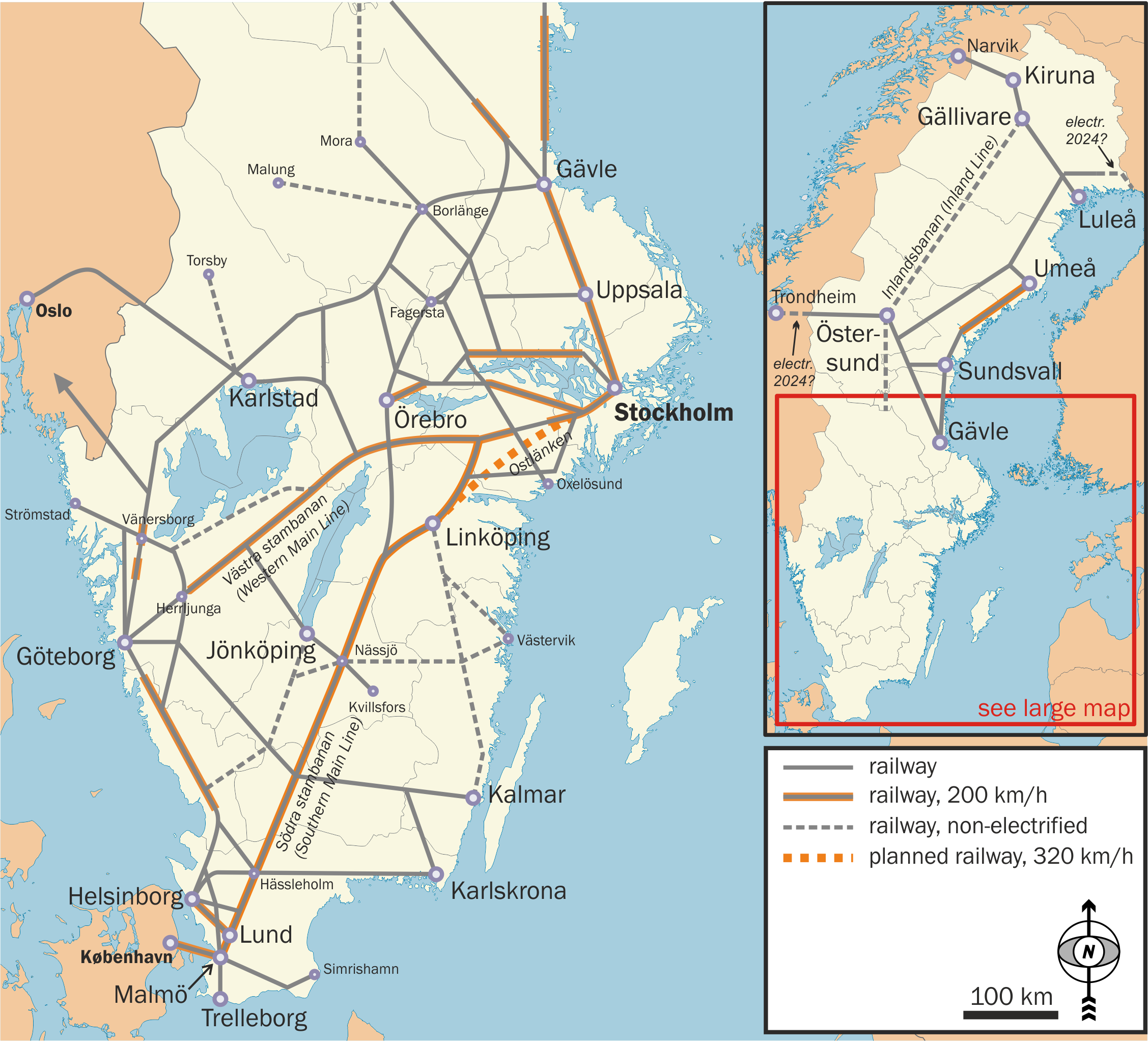
 Overview of important lines
 -
 Overview of lines where 200 km/h is in use
 -
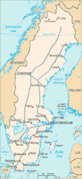
 Locations of Swedish cities
 -
 Source for the background image (slightly modified).
Size of this preview:
661 × 599 pixels. Other resolutions:
265 × 240 pixels |
530 × 480 pixels |
847 × 768 pixels |
1,130 × 1,024 pixels |
2,255 × 2,044 pixels.
Original file (2,255 × 2,044 pixels, file size: 1.17 MB, MIME type: image/png)
| This is a file from the
Wikimedia Commons. Information from its
description page there is shown below. Commons is a freely licensed media file repository. You can help. |
Summary
| Description |
English: Map of railways in Sweden. Sources used:
|
| Date | |
| Source | Own work |
| Author | Classical geographer |


.svg)
.svg)
Licensing
I, the copyright holder of this work, hereby publish it under the following licenses:
This file is licensed under the
Creative Commons
Attribution-Share Alike 3.0 Unported license.
- You are free:
- to share – to copy, distribute and transmit the work
- to remix – to adapt the work
- Under the following conditions:
- attribution – You must give appropriate credit, provide a link to the license, and indicate if changes were made. You may do so in any reasonable manner, but not in any way that suggests the licensor endorses you or your use.
- share alike – If you remix, transform, or build upon the material, you must distribute your contributions under the same or compatible license as the original.

|
Permission is granted to copy, distribute and/or modify this document under the terms of the GNU Free Documentation License, Version 1.2 or any later version published by the Free Software Foundation; with no Invariant Sections, no Front-Cover Texts, and no Back-Cover Texts. A copy of the license is included in the section entitled GNU Free Documentation License. |
You may select the license of your choice.
File history
Click on a date/time to view the file as it appeared at that time.
| Date/Time | Thumbnail | Dimensions | User | Comment | |
|---|---|---|---|---|---|
| current | 10:06, 10 December 2021 |
| 2,255 × 2,044 (1.17 MB) | Classical geographer | Updated planned electrifications across Finnish and Norwegian borders, and added a few junction names. |
| 23:33, 2 March 2014 |
 | 2,255 × 2,044 (990 KB) | Kopiersperre | optipng | |
| 17:57, 12 September 2013 |
 | 2,255 × 2,044 (1.5 MB) | Classical geographer | Updated Inlandsbanan Östersund-Mora. Minor corrections around Fagersta. | |
| 19:35, 21 July 2013 |
 | 2,255 × 2,044 (1.49 MB) | Classical geographer | Corrected Uppsala-Mora, speed of Southern Main Line; added three more railway names in Swedish+English. | |
| 10:50, 13 September 2012 |
 | 2,255 × 2,044 (1.18 MB) | Classical geographer | Indicated high-speed w:Bothnia Line. | |
| 10:18, 13 September 2012 |
 | 2,255 × 2,044 (1.18 MB) | Classical geographer | Added Ostlänken planned high-speed line. | |
| 16:59, 26 April 2012 |
 | 3,006 × 2,724 (1.98 MB) | Classical geographer | Added Inlandsbanen. | |
| 21:08, 31 August 2010 |
 | 3,006 × 2,724 (1.2 MB) | Classical geographer | {{Information |Description={{en|1=Map of railways in Sweden. Sources used: * [http://www.bueker.net/trainspotting/map.php?file=maps/scandinavian-peninsulas-network/scandinavian-peninsulas.gif Boris Chomenko's excellent drawing] * [http://www.alleuroperail |
File usage
The following pages on the English Wikipedia use this file (pages on other projects are not listed):
Global file usage
The following other wikis use this file:
- Usage on da.wikipedia.org
- Malmbanan
- Sveriges jernbaner
- Blekinge kustbana
- Västra stambanan
- Södra stambanan
- Norra stambanan
- Stambanan genom övre Norrland
- Värmlandsbanan
- Botniabanan
- Mittbanan
- Inlandsbanan
- Kust till kust-banan
- Bergslagsbanan
- Stångådalsbanan
- Norge/Vänerbanen
- Västkustbanan
- Ostkustbanan
- Kontinentalbanan
- Dalabanen
- Skånebanan
- Ystadbanan
- Usage on de.wikipedia.org
- Usage on es.wikipedia.org
- Usage on fi.wikipedia.org
- Usage on fr.wikipedia.org
- Usage on he.wikivoyage.org
- Usage on hu.wikipedia.org
- Usage on pl.wikipedia.org
- Usage on pt.wikipedia.org
- Usage on zh.wikipedia.org
Metadata
Size of this preview:
661 × 599 pixels. Other resolutions:
265 × 240 pixels |
530 × 480 pixels |
847 × 768 pixels |
1,130 × 1,024 pixels |
2,255 × 2,044 pixels.
Original file (2,255 × 2,044 pixels, file size: 1.17 MB, MIME type: image/png)
| This is a file from the
Wikimedia Commons. Information from its
description page there is shown below. Commons is a freely licensed media file repository. You can help. |
Summary
| Description |
English: Map of railways in Sweden. Sources used:
|
| Date | |
| Source | Own work |
| Author | Classical geographer |
Licensing
I, the copyright holder of this work, hereby publish it under the following licenses:
This file is licensed under the
Creative Commons
Attribution-Share Alike 3.0 Unported license.
- You are free:
- to share – to copy, distribute and transmit the work
- to remix – to adapt the work
- Under the following conditions:
- attribution – You must give appropriate credit, provide a link to the license, and indicate if changes were made. You may do so in any reasonable manner, but not in any way that suggests the licensor endorses you or your use.
- share alike – If you remix, transform, or build upon the material, you must distribute your contributions under the same or compatible license as the original.
|
|
Permission is granted to copy, distribute and/or modify this document under the terms of the GNU Free Documentation License, Version 1.2 or any later version published by the Free Software Foundation; with no Invariant Sections, no Front-Cover Texts, and no Back-Cover Texts. A copy of the license is included in the section entitled GNU Free Documentation License. |
You may select the license of your choice.
File history
Click on a date/time to view the file as it appeared at that time.
| Date/Time | Thumbnail | Dimensions | User | Comment | |
|---|---|---|---|---|---|
| current | 10:06, 10 December 2021 |
| 2,255 × 2,044 (1.17 MB) | Classical geographer | Updated planned electrifications across Finnish and Norwegian borders, and added a few junction names. |
| 23:33, 2 March 2014 |
| 2,255 × 2,044 (990 KB) | Kopiersperre | optipng | |
| 17:57, 12 September 2013 |
| 2,255 × 2,044 (1.5 MB) | Classical geographer | Updated Inlandsbanan Östersund-Mora. Minor corrections around Fagersta. | |
| 19:35, 21 July 2013 |
| 2,255 × 2,044 (1.49 MB) | Classical geographer | Corrected Uppsala-Mora, speed of Southern Main Line; added three more railway names in Swedish+English. | |
| 10:50, 13 September 2012 |
| 2,255 × 2,044 (1.18 MB) | Classical geographer | Indicated high-speed w:Bothnia Line. | |
| 10:18, 13 September 2012 |
| 2,255 × 2,044 (1.18 MB) | Classical geographer | Added Ostlänken planned high-speed line. | |
| 16:59, 26 April 2012 |
| 3,006 × 2,724 (1.98 MB) | Classical geographer | Added Inlandsbanen. | |
| 21:08, 31 August 2010 |
| 3,006 × 2,724 (1.2 MB) | Classical geographer | {{Information |Description={{en|1=Map of railways in Sweden. Sources used: * [http://www.bueker.net/trainspotting/map.php?file=maps/scandinavian-peninsulas-network/scandinavian-peninsulas.gif Boris Chomenko's excellent drawing] * [http://www.alleuroperail |
File usage
The following pages on the English Wikipedia use this file (pages on other projects are not listed):
Global file usage
The following other wikis use this file:
- Usage on da.wikipedia.org
- Malmbanan
- Sveriges jernbaner
- Blekinge kustbana
- Västra stambanan
- Södra stambanan
- Norra stambanan
- Stambanan genom övre Norrland
- Värmlandsbanan
- Botniabanan
- Mittbanan
- Inlandsbanan
- Kust till kust-banan
- Bergslagsbanan
- Stångådalsbanan
- Norge/Vänerbanen
- Västkustbanan
- Ostkustbanan
- Kontinentalbanan
- Dalabanen
- Skånebanan
- Ystadbanan
- Usage on de.wikipedia.org
- Usage on es.wikipedia.org
- Usage on fi.wikipedia.org
- Usage on fr.wikipedia.org
- Usage on he.wikivoyage.org
- Usage on hu.wikipedia.org
- Usage on pl.wikipedia.org
- Usage on pt.wikipedia.org
- Usage on zh.wikipedia.org