Photos • Location


Size of this preview:
800 × 533 pixels. Other resolutions:
320 × 213 pixels |
640 × 427 pixels |
1,024 × 683 pixels |
1,280 × 853 pixels |
2,560 × 1,707 pixels |
3,456 × 2,304 pixels.
Original file (3,456 × 2,304 pixels, file size: 6.54 MB, MIME type: image/jpeg)
| This is a file from the
Wikimedia Commons. Information from its
description page there is shown below. Commons is a freely licensed media file repository. You can help. |
| Description |
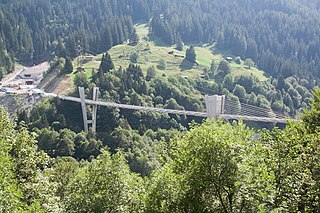
Deutsch: Die Sunniberbgrücke zwischen Serneus und Klosters Dorf, Schweiz; Aufnahme von der alten Hauptstrasse aus |
| Date | |
| Source | Own work |
| Author | Ikiwaner |
| Camera location | | View this and other nearby images on: OpenStreetMap |
|
|---|

|
Permission is granted to copy, distribute and/or modify this document under the terms of the GNU Free Documentation License, Version 1.2 or any later version published by the Free Software Foundation; with no Invariant Sections, no Front-Cover Texts, and no Back-Cover Texts. A copy of the license is included in the section entitled GNU Free Documentation License. |
| This file is licensed under the Creative Commons Attribution-Share Alike 3.0 Unported license. | ||
| ||
| This licensing tag was added to this file as part of the GFDL licensing update. |

File history
Click on a date/time to view the file as it appeared at that time.
| Date/Time | Thumbnail | Dimensions | User | Comment | |
|---|---|---|---|---|---|
| current | 15:13, 26 July 2006 |
| 3,456 × 2,304 (6.54 MB) | Ikiwaner | Die Sunniberbgrücke zwischen Serneus und Klosters Dorf, Schweiz Aufnahme von der alten Hauptstrasse aus Eigenes Bild vom 25. Juli 2006 {{GFDL}} Category:Cities and villages in the canton of Grisons Category:Sunnibergbrücke |
File usage
The following pages on the English Wikipedia use this file (pages on other projects are not listed):
Global file usage
The following other wikis use this file:
- Usage on de.wikipedia.org
Size of this preview:
800 × 533 pixels. Other resolutions:
320 × 213 pixels |
640 × 427 pixels |
1,024 × 683 pixels |
1,280 × 853 pixels |
2,560 × 1,707 pixels |
3,456 × 2,304 pixels.
Original file (3,456 × 2,304 pixels, file size: 6.54 MB, MIME type: image/jpeg)
| This is a file from the
Wikimedia Commons. Information from its
description page there is shown below. Commons is a freely licensed media file repository. You can help. |
| Description |
Deutsch: Die Sunniberbgrücke zwischen Serneus und Klosters Dorf, Schweiz; Aufnahme von der alten Hauptstrasse aus |
| Date | |
| Source | Own work |
| Author | Ikiwaner |
| Camera location | | View this and other nearby images on: OpenStreetMap |
|
|---|
|
|
Permission is granted to copy, distribute and/or modify this document under the terms of the GNU Free Documentation License, Version 1.2 or any later version published by the Free Software Foundation; with no Invariant Sections, no Front-Cover Texts, and no Back-Cover Texts. A copy of the license is included in the section entitled GNU Free Documentation License. |
| This file is licensed under the Creative Commons Attribution-Share Alike 3.0 Unported license. | ||
| ||
| This licensing tag was added to this file as part of the GFDL licensing update. |
File history
Click on a date/time to view the file as it appeared at that time.
| Date/Time | Thumbnail | Dimensions | User | Comment | |
|---|---|---|---|---|---|
| current | 15:13, 26 July 2006 |
| 3,456 × 2,304 (6.54 MB) | Ikiwaner | Die Sunniberbgrücke zwischen Serneus und Klosters Dorf, Schweiz Aufnahme von der alten Hauptstrasse aus Eigenes Bild vom 25. Juli 2006 {{GFDL}} Category:Cities and villages in the canton of Grisons Category:Sunnibergbrücke |
File usage
The following pages on the English Wikipedia use this file (pages on other projects are not listed):
Global file usage
The following other wikis use this file:
- Usage on de.wikipedia.org