StraitsMackinac_ISS010-E-20813.jpg (320 × 240 pixels, file size: 18 KB, MIME type: image/jpeg)
| This is a file from the
Wikimedia Commons. Information from its
description page there is shown below. Commons is a freely licensed media file repository. You can help. |
|
This is an image of a place or building that is listed on the
National Register of Historic Places in the
United States of America. Its reference number is
88000442. |
Summary
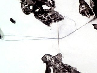
| Description | w:Straits of Mackinac (Michigan, USA) frozen over. The w:Mackinac Bridge stretches over the ice, while paths made by icebreakers cut through the ice. |
| Date | |
| Source | http://earthobservatory.nasa.gov/Newsroom/NewImages/images.php3?img_id=16890 |
| Author | ISS Crew Earth Observations experiment and the Image Science & Analysis Group at the Johnson Space Center. Cropped and adjusted by Howcheng. |
| Permission ( Reusing this file) |
NASA, public domain |
| Other versions | Original sample available at source URL. |
| Object location |
| View this and other nearby images on: OpenStreetMap |
|
|---|
Licensing
This file is in the
public domain in the United States because it was created by the Image Science & Analysis Laboratory, of the
NASA Johnson Space Center. NASA copyright policy states that "NASA material is not protected by copyright unless noted". (
NASA media use guidelines or
Conditions of Use of Astronaut Photographs).
Photo source:
ISS010-E-20813.
|
File history
Click on a date/time to view the file as it appeared at that time.
| Date/Time | Thumbnail | Dimensions | User | Comment | |
|---|---|---|---|---|---|
| current | 21:55, 12 May 2006 |
| 320 × 240 (18 KB) | Holly Cheng | ==Summary== {{Information | Description= w:Straits of Mackinac (Michigan, USA) frozen over. The w:Mackinac Bridge stretches over the ice, while paths made by icebreakers cut through the ice. | Source=http://earthobservatory.nasa.gov/Newsroom/NewIma |
File usage
Global file usage
The following other wikis use this file:
- Usage on ceb.wikipedia.org
- Usage on es.wikipedia.org
- Usage on fr.wikipedia.org
- Usage on vi.wikipedia.org
- Usage on www.wikidata.org
Metadata
StraitsMackinac_ISS010-E-20813.jpg (320 × 240 pixels, file size: 18 KB, MIME type: image/jpeg)
| This is a file from the
Wikimedia Commons. Information from its
description page there is shown below. Commons is a freely licensed media file repository. You can help. |
|
This is an image of a place or building that is listed on the
National Register of Historic Places in the
United States of America. Its reference number is
88000442. |
Summary
| Description | w:Straits of Mackinac (Michigan, USA) frozen over. The w:Mackinac Bridge stretches over the ice, while paths made by icebreakers cut through the ice. |
| Date | |
| Source | http://earthobservatory.nasa.gov/Newsroom/NewImages/images.php3?img_id=16890 |
| Author | ISS Crew Earth Observations experiment and the Image Science & Analysis Group at the Johnson Space Center. Cropped and adjusted by Howcheng. |
| Permission ( Reusing this file) |
NASA, public domain |
| Other versions | Original sample available at source URL. |
| Object location |
| View this and other nearby images on: OpenStreetMap |
|
|---|
Licensing
This file is in the
public domain in the United States because it was created by the Image Science & Analysis Laboratory, of the
NASA Johnson Space Center. NASA copyright policy states that "NASA material is not protected by copyright unless noted". (
NASA media use guidelines or
Conditions of Use of Astronaut Photographs).
Photo source:
ISS010-E-20813.
|
File history
Click on a date/time to view the file as it appeared at that time.
| Date/Time | Thumbnail | Dimensions | User | Comment | |
|---|---|---|---|---|---|
| current | 21:55, 12 May 2006 |
| 320 × 240 (18 KB) | Holly Cheng | ==Summary== {{Information | Description= w:Straits of Mackinac (Michigan, USA) frozen over. The w:Mackinac Bridge stretches over the ice, while paths made by icebreakers cut through the ice. | Source=http://earthobservatory.nasa.gov/Newsroom/NewIma |
File usage
Global file usage
The following other wikis use this file:
- Usage on ceb.wikipedia.org
- Usage on es.wikipedia.org
- Usage on fr.wikipedia.org
- Usage on vi.wikipedia.org
- Usage on www.wikidata.org