
Size of this PNG preview of this SVG file:
443 × 599 pixels. Other resolutions:
177 × 240 pixels |
355 × 480 pixels |
567 × 768 pixels |
757 × 1,024 pixels |
1,513 × 2,048 pixels |
592 × 801 pixels.
Original file (SVG file, nominally 592 × 801 pixels, file size: 118 KB)
| This is a file from the
Wikimedia Commons. Information from its
description page there is shown below. Commons is a freely licensed media file repository. You can help. |
Summary
| Description |
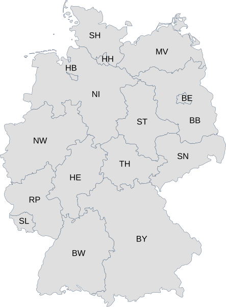
English: Map of Germany with each state labelled with its
ISO 3166-2 subcode.
Deutsch: Karte von Deutschland mit den Codes der Bundesländer nach
ISO 3166-2:DE |
| Date | |
| Source | File:Karte Bundesrepublik Deutschland.svg and File:Linke Landtage.svg |
| Author | User:David Liuzzo and User:Voland77 |
Licensing
This file is licensed under the
Creative Commons
Attribution 3.0 Unported license.
- You are free:
- to share – to copy, distribute and transmit the work
- to remix – to adapt the work
- Under the following conditions:
- attribution – You must give appropriate credit, provide a link to the license, and indicate if changes were made. You may do so in any reasonable manner, but not in any way that suggests the licensor endorses you or your use.
File history
Click on a date/time to view the file as it appeared at that time.
| Date/Time | Thumbnail | Dimensions | User | Comment | |
|---|---|---|---|---|---|
| current | 06:34, 26 March 2009 |
| 592 × 801 (118 KB) | Chanheigeorge | {{Information |Description=Map of Germany with each state labelled with its ISO 3166-2 subcode. |Source= File:Karte Bundesrepublik Deutschland.svg and File:Linke Landtage.svg |Date=2009-03-26 |Author= User:David Liuzzo and User:Voland77 |Per |
File usage
The following pages on the English Wikipedia use this file (pages on other projects are not listed):
Global file usage
The following other wikis use this file:
- Usage on af.wikipedia.org
- Usage on bs.wikipedia.org
- Usage on ca.wikipedia.org
- Usage on cs.wikipedia.org
- Usage on de.wikipedia.org
- Usage on eo.wikipedia.org
- Usage on fo.wikipedia.org
- Usage on frr.wikipedia.org
- Usage on id.wikipedia.org
- Usage on ka.wikipedia.org
- Usage on ku.wikipedia.org
- Usage on no.wikipedia.org
- Usage on pl.wiktionary.org
- Usage on pt.wikipedia.org
- Usage on roa-tara.wikipedia.org
- Usage on ru.wikipedia.org
- Usage on sv.wikipedia.org
- Usage on tr.wikipedia.org
- Usage on vi.wikipedia.org
- Usage on zh-min-nan.wikipedia.org
- Usage on zh.wikipedia.org
Size of this PNG preview of this SVG file:
443 × 599 pixels. Other resolutions:
177 × 240 pixels |
355 × 480 pixels |
567 × 768 pixels |
757 × 1,024 pixels |
1,513 × 2,048 pixels |
592 × 801 pixels.
Original file (SVG file, nominally 592 × 801 pixels, file size: 118 KB)
| This is a file from the
Wikimedia Commons. Information from its
description page there is shown below. Commons is a freely licensed media file repository. You can help. |
Summary
| Description |
English: Map of Germany with each state labelled with its
ISO 3166-2 subcode.
Deutsch: Karte von Deutschland mit den Codes der Bundesländer nach
ISO 3166-2:DE |
| Date | |
| Source | File:Karte Bundesrepublik Deutschland.svg and File:Linke Landtage.svg |
| Author | User:David Liuzzo and User:Voland77 |
Licensing
This file is licensed under the
Creative Commons
Attribution 3.0 Unported license.
- You are free:
- to share – to copy, distribute and transmit the work
- to remix – to adapt the work
- Under the following conditions:
- attribution – You must give appropriate credit, provide a link to the license, and indicate if changes were made. You may do so in any reasonable manner, but not in any way that suggests the licensor endorses you or your use.
File history
Click on a date/time to view the file as it appeared at that time.
| Date/Time | Thumbnail | Dimensions | User | Comment | |
|---|---|---|---|---|---|
| current | 06:34, 26 March 2009 |
| 592 × 801 (118 KB) | Chanheigeorge | {{Information |Description=Map of Germany with each state labelled with its ISO 3166-2 subcode. |Source= File:Karte Bundesrepublik Deutschland.svg and File:Linke Landtage.svg |Date=2009-03-26 |Author= User:David Liuzzo and User:Voland77 |Per |
File usage
The following pages on the English Wikipedia use this file (pages on other projects are not listed):
Global file usage
The following other wikis use this file:
- Usage on af.wikipedia.org
- Usage on bs.wikipedia.org
- Usage on ca.wikipedia.org
- Usage on cs.wikipedia.org
- Usage on de.wikipedia.org
- Usage on eo.wikipedia.org
- Usage on fo.wikipedia.org
- Usage on frr.wikipedia.org
- Usage on id.wikipedia.org
- Usage on ka.wikipedia.org
- Usage on ku.wikipedia.org
- Usage on no.wikipedia.org
- Usage on pl.wiktionary.org
- Usage on pt.wikipedia.org
- Usage on roa-tara.wikipedia.org
- Usage on ru.wikipedia.org
- Usage on sv.wikipedia.org
- Usage on tr.wikipedia.org
- Usage on vi.wikipedia.org
- Usage on zh-min-nan.wikipedia.org
- Usage on zh.wikipedia.org