
Size of this preview:
643 × 599 pixels. Other resolutions:
258 × 240 pixels |
515 × 480 pixels |
1,016 × 947 pixels.
Original file (1,016 × 947 pixels, file size: 406 KB, MIME type: image/jpeg)
| This is a file from the
Wikimedia Commons. Information from its
description page there is shown below. Commons is a freely licensed media file repository. You can help. |
Summary
| Description |
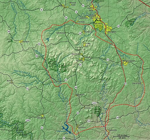
English: Detailed shaded relief map of the
St. Francois Mountains. The red dashed line delineates the St. Francois Mountain physiographic region as delineated in "Landforms of Missouri", Walter A. Schroeder, 1990. Metadata for the
GIS data file:
|
| Date | |
| Source | Own work |
| Author | Kbh3rd |
Licensing
I, the copyright holder of this work, hereby publish it under the following licenses:
This file is licensed under the
Creative Commons
Attribution-Share Alike 3.0 Unported license.
- You are free:
- to share – to copy, distribute and transmit the work
- to remix – to adapt the work
- Under the following conditions:
- attribution – You must give appropriate credit, provide a link to the license, and indicate if changes were made. You may do so in any reasonable manner, but not in any way that suggests the licensor endorses you or your use.
- share alike – If you remix, transform, or build upon the material, you must distribute your contributions under the same or compatible license as the original.

|
Permission is granted to copy, distribute and/or modify this document under the terms of the GNU Free Documentation License, Version 1.2 or any later version published by the Free Software Foundation; with no Invariant Sections, no Front-Cover Texts, and no Back-Cover Texts. A copy of the license is included in the section entitled GNU Free Documentation License. |
You may select the license of your choice.
File history
Click on a date/time to view the file as it appeared at that time.
| Date/Time | Thumbnail | Dimensions | User | Comment | |
|---|---|---|---|---|---|
| current | 20:01, 11 September 2013 |
| 1,016 × 947 (406 KB) | Kbh3rd | Fill outline of Council Bluff Lake at headwaters of Big River. |
| 03:17, 22 February 2009 |
 | 1,016 × 947 (395 KB) | Kbh3rd | ||
| 04:39, 17 February 2009 |
 | 1,016 × 947 (394 KB) | Kbh3rd | {{Information |Description={{en|1=Detailed shaded relief map of the St. Francois Mountains. The red dashed line delineates the St. Francois Mountain physiographic province.}} |Source=Own work by uploader |Author=[[User:Kbh3 |
File usage
The following pages on the English Wikipedia use this file (pages on other projects are not listed):
Global file usage
The following other wikis use this file:
- Usage on ru.wikipedia.org
Metadata
Size of this preview:
643 × 599 pixels. Other resolutions:
258 × 240 pixels |
515 × 480 pixels |
1,016 × 947 pixels.
Original file (1,016 × 947 pixels, file size: 406 KB, MIME type: image/jpeg)
| This is a file from the
Wikimedia Commons. Information from its
description page there is shown below. Commons is a freely licensed media file repository. You can help. |
Summary
| Description |
English: Detailed shaded relief map of the
St. Francois Mountains. The red dashed line delineates the St. Francois Mountain physiographic region as delineated in "Landforms of Missouri", Walter A. Schroeder, 1990. Metadata for the
GIS data file:
|
| Date | |
| Source | Own work |
| Author | Kbh3rd |
Licensing
I, the copyright holder of this work, hereby publish it under the following licenses:
This file is licensed under the
Creative Commons
Attribution-Share Alike 3.0 Unported license.
- You are free:
- to share – to copy, distribute and transmit the work
- to remix – to adapt the work
- Under the following conditions:
- attribution – You must give appropriate credit, provide a link to the license, and indicate if changes were made. You may do so in any reasonable manner, but not in any way that suggests the licensor endorses you or your use.
- share alike – If you remix, transform, or build upon the material, you must distribute your contributions under the same or compatible license as the original.
|
|
Permission is granted to copy, distribute and/or modify this document under the terms of the GNU Free Documentation License, Version 1.2 or any later version published by the Free Software Foundation; with no Invariant Sections, no Front-Cover Texts, and no Back-Cover Texts. A copy of the license is included in the section entitled GNU Free Documentation License. |
You may select the license of your choice.
File history
Click on a date/time to view the file as it appeared at that time.
| Date/Time | Thumbnail | Dimensions | User | Comment | |
|---|---|---|---|---|---|
| current | 20:01, 11 September 2013 |
| 1,016 × 947 (406 KB) | Kbh3rd | Fill outline of Council Bluff Lake at headwaters of Big River. |
| 03:17, 22 February 2009 |
| 1,016 × 947 (395 KB) | Kbh3rd | ||
| 04:39, 17 February 2009 |
| 1,016 × 947 (394 KB) | Kbh3rd | {{Information |Description={{en|1=Detailed shaded relief map of the St. Francois Mountains. The red dashed line delineates the St. Francois Mountain physiographic province.}} |Source=Own work by uploader |Author=[[User:Kbh3 |
File usage
The following pages on the English Wikipedia use this file (pages on other projects are not listed):
Global file usage
The following other wikis use this file:
- Usage on ru.wikipedia.org