Photos • Location


Size of this PNG preview of this SVG file:
729 × 599 pixels. Other resolutions:
292 × 240 pixels |
584 × 480 pixels |
934 × 768 pixels |
1,246 × 1,024 pixels |
2,491 × 2,048 pixels |
1,181 × 971 pixels.
Original file (SVG file, nominally 1,181 × 971 pixels, file size: 138 KB)
| This is a file from the
Wikimedia Commons. Information from its
description page there is shown below. Commons is a freely licensed media file repository. You can help. |
Summary
| Description |
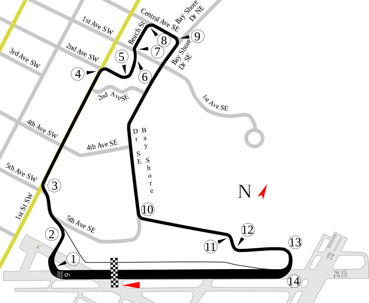
English: Track map of the route for the
Honda Grand Prix of St. Petersburg. Select streets and the airport that the track uses are shown for reference. |
| Date | 8-2-2008 |
| Source | Own work |
| Author | Will Pittenger |
| Other versions |
|

.svg)
| Camera location |
| View this and other nearby images on: OpenStreetMap |
|
|---|
Licensing
I, the copyright holder of this work, hereby publish it under the following license:
This file is licensed under the
Creative Commons
Attribution-Share Alike 3.0 Unported license.
- You are free:
- to share – to copy, distribute and transmit the work
- to remix – to adapt the work
- Under the following conditions:
- attribution – You must give appropriate credit, provide a link to the license, and indicate if changes were made. You may do so in any reasonable manner, but not in any way that suggests the licensor endorses you or your use.
- share alike – If you remix, transform, or build upon the material, you must distribute your contributions under the same or compatible license as the original.
File history
Click on a date/time to view the file as it appeared at that time.
| Date/Time | Thumbnail | Dimensions | User | Comment | |
|---|---|---|---|---|---|
| current | 09:39, 2 August 2008 |
| 1,181 × 971 (138 KB) | Will Pittenger | Previous version still had vertical text. Sorry. |
| 09:38, 2 August 2008 |
 | 1,181 × 971 (118 KB) | Will Pittenger | New version gets around two MediaWiki/RSVG bugs (listed below) by converting affected objects into paths. If you need to edit the file, please use the previous version. * Text on paths gets ignored * Vertical text is ignored | |
| 09:29, 2 August 2008 |
 | 1,181 × 971 (97 KB) | Will Pittenger | {{Information |Description={{en|1=Track map of the route for the w:Honda Grand Prix of St. Petersburg. Select streets and the airport that the track uses are shown for reference.}} |Source=Own work by uploader |Author=[[User:Will Pittenger|Will Pitt |
File usage
The following pages on the English Wikipedia use this file (pages on other projects are not listed):
- 2003 Grand Prix of St. Petersburg
- 2006 Honda Grand Prix of St. Petersburg
- 2007 Honda Grand Prix of St. Petersburg
- 2007 Sports Car Challenge of St. Petersburg
- 2008 Honda Grand Prix of St. Petersburg
- 2008 Sports Car Challenge of St. Petersburg
- 2009 Honda Grand Prix of St. Petersburg
- 2009 Sports Car Challenge of St. Petersburg
- 2010 Honda Grand Prix of St. Petersburg
- 2011 Honda Grand Prix of St. Petersburg
- 2012 Honda Grand Prix of St. Petersburg
- 2013 Honda Grand Prix of St. Petersburg
- 2014 Firestone Grand Prix of St. Petersburg
- 2015 Firestone Grand Prix of St. Petersburg
- 2016 Firestone Grand Prix of St. Petersburg
- 2017 Firestone Grand Prix of St. Petersburg
- 2018 Firestone Grand Prix of St. Petersburg
- 2019 Firestone Grand Prix of St. Petersburg
- 2021 Firestone Grand Prix of St. Petersburg
- 2022 Firestone Grand Prix of St. Petersburg
- 2023 Firestone Grand Prix of St. Petersburg
- 2024 Firestone Grand Prix of St. Petersburg
- Grand Prix of St. Petersburg
- List of American Le Mans Series circuits
- List of Champ Car circuits
- List of GT World Challenge America circuits
- List of IMSA SportsCar Championship circuits
- List of IndyCar Series racetracks
- User:TorontoGuy79/sandbox
Global file usage
The following other wikis use this file:
- Usage on ar.wikipedia.org
- Usage on de.wikipedia.org
- Streets of St. Petersburg
- Liste der IndyCar/ChampCar-Rennstrecken
- Firestone Grand Prix of St. Petersburg
- Honda Grand Prix of St. Petersburg 2012
- Honda Grand Prix of St. Petersburg 2013
- Firestone Grand Prix of St. Petersburg 2014
- Firestone Grand Prix of St. Petersburg 2015
- Firestone Grand Prix of St. Petersburg 2016
- Grand Prix of St. Petersburg 2022
- Grand Prix of St. Petersburg 2023
- Grand Prix of St. Petersburg 2024
- Usage on es.wikipedia.org
- Gran Premio de San Petersburgo
- Temporada 2011 de IndyCar Series
- Anexo:Circuitos de campeonatos de monoplazas de Estados Unidos
- Temporada 2014 de Indy Lights
- Temporada 2015 de IndyCar Series
- Anexo:Gran Premio de San Petersburgo de Indy Lights 2016
- Temporada 2016 de IndyCar Series
- Anexo:Gran Premio de San Petersburgo de 2023
- Usage on fr.wikipedia.org
- Usage on hr.wikipedia.org
- Usage on hu.wikipedia.org
- Honda Grand Prix of St. Petersburg
- 2012-es Honda Grand Prix of St. Petersburg
- 2013-as Honda Grand Prix of St. Petersburg
- 2016-os Firestone Grand Prix of St. Petersburg
- 2019-es IndyCar Series szezon
- 2020-as IndyCar Series szezon
- 2015-ös Indy Lights-szezon
- 2019-es Indy Lights-szezon
- 2016-os Indy Lights-szezon
- 2017-es Indy Lights-szezon
- 2018-as Indy Lights-szezon
- 2014-es Indy Lights-szezon
- 2013-as Indy Lights-szezon
- 2012-es Indy Lights-szezon
- 2011-es Indy Lights-szezon
- 2020-as Indy Lights-szezon
- 2021-es IndyCar Series szezon
- Usage on id.wikipedia.org
- Usage on it.wikipedia.org
- Usage on ja.wikipedia.org
- Usage on lv.wikipedia.org
- Usage on nl.wikipedia.org
View more global usage of this file.
Size of this PNG preview of this SVG file:
729 × 599 pixels. Other resolutions:
292 × 240 pixels |
584 × 480 pixels |
934 × 768 pixels |
1,246 × 1,024 pixels |
2,491 × 2,048 pixels |
1,181 × 971 pixels.
Original file (SVG file, nominally 1,181 × 971 pixels, file size: 138 KB)
| This is a file from the
Wikimedia Commons. Information from its
description page there is shown below. Commons is a freely licensed media file repository. You can help. |
Summary
| Description |
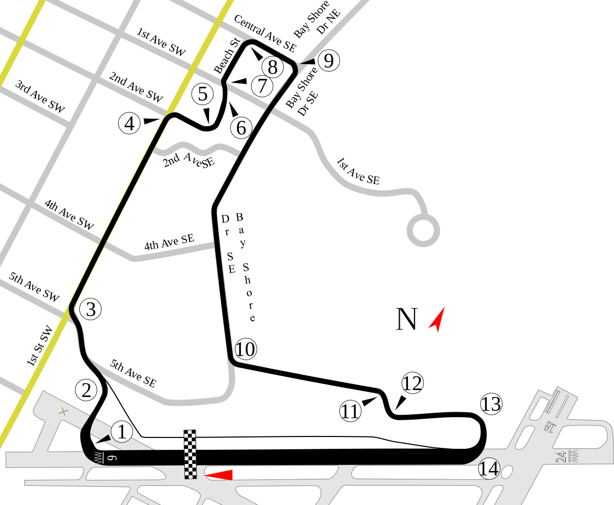
English: Track map of the route for the
Honda Grand Prix of St. Petersburg. Select streets and the airport that the track uses are shown for reference. |
| Date | 8-2-2008 |
| Source | Own work |
| Author | Will Pittenger |
| Other versions |
|
| Camera location |
| View this and other nearby images on: OpenStreetMap |
|
|---|
Licensing
I, the copyright holder of this work, hereby publish it under the following license:
This file is licensed under the
Creative Commons
Attribution-Share Alike 3.0 Unported license.
- You are free:
- to share – to copy, distribute and transmit the work
- to remix – to adapt the work
- Under the following conditions:
- attribution – You must give appropriate credit, provide a link to the license, and indicate if changes were made. You may do so in any reasonable manner, but not in any way that suggests the licensor endorses you or your use.
- share alike – If you remix, transform, or build upon the material, you must distribute your contributions under the same or compatible license as the original.
File history
Click on a date/time to view the file as it appeared at that time.
| Date/Time | Thumbnail | Dimensions | User | Comment | |
|---|---|---|---|---|---|
| current | 09:39, 2 August 2008 |
| 1,181 × 971 (138 KB) | Will Pittenger | Previous version still had vertical text. Sorry. |
| 09:38, 2 August 2008 |
| 1,181 × 971 (118 KB) | Will Pittenger | New version gets around two MediaWiki/RSVG bugs (listed below) by converting affected objects into paths. If you need to edit the file, please use the previous version. * Text on paths gets ignored * Vertical text is ignored | |
| 09:29, 2 August 2008 |
| 1,181 × 971 (97 KB) | Will Pittenger | {{Information |Description={{en|1=Track map of the route for the w:Honda Grand Prix of St. Petersburg. Select streets and the airport that the track uses are shown for reference.}} |Source=Own work by uploader |Author=[[User:Will Pittenger|Will Pitt |
File usage
The following pages on the English Wikipedia use this file (pages on other projects are not listed):
- 2003 Grand Prix of St. Petersburg
- 2006 Honda Grand Prix of St. Petersburg
- 2007 Honda Grand Prix of St. Petersburg
- 2007 Sports Car Challenge of St. Petersburg
- 2008 Honda Grand Prix of St. Petersburg
- 2008 Sports Car Challenge of St. Petersburg
- 2009 Honda Grand Prix of St. Petersburg
- 2009 Sports Car Challenge of St. Petersburg
- 2010 Honda Grand Prix of St. Petersburg
- 2011 Honda Grand Prix of St. Petersburg
- 2012 Honda Grand Prix of St. Petersburg
- 2013 Honda Grand Prix of St. Petersburg
- 2014 Firestone Grand Prix of St. Petersburg
- 2015 Firestone Grand Prix of St. Petersburg
- 2016 Firestone Grand Prix of St. Petersburg
- 2017 Firestone Grand Prix of St. Petersburg
- 2018 Firestone Grand Prix of St. Petersburg
- 2019 Firestone Grand Prix of St. Petersburg
- 2021 Firestone Grand Prix of St. Petersburg
- 2022 Firestone Grand Prix of St. Petersburg
- 2023 Firestone Grand Prix of St. Petersburg
- 2024 Firestone Grand Prix of St. Petersburg
- Grand Prix of St. Petersburg
- List of American Le Mans Series circuits
- List of Champ Car circuits
- List of GT World Challenge America circuits
- List of IMSA SportsCar Championship circuits
- List of IndyCar Series racetracks
- User:TorontoGuy79/sandbox
Global file usage
The following other wikis use this file:
- Usage on ar.wikipedia.org
- Usage on de.wikipedia.org
- Streets of St. Petersburg
- Liste der IndyCar/ChampCar-Rennstrecken
- Firestone Grand Prix of St. Petersburg
- Honda Grand Prix of St. Petersburg 2012
- Honda Grand Prix of St. Petersburg 2013
- Firestone Grand Prix of St. Petersburg 2014
- Firestone Grand Prix of St. Petersburg 2015
- Firestone Grand Prix of St. Petersburg 2016
- Grand Prix of St. Petersburg 2022
- Grand Prix of St. Petersburg 2023
- Grand Prix of St. Petersburg 2024
- Usage on es.wikipedia.org
- Gran Premio de San Petersburgo
- Temporada 2011 de IndyCar Series
- Anexo:Circuitos de campeonatos de monoplazas de Estados Unidos
- Temporada 2014 de Indy Lights
- Temporada 2015 de IndyCar Series
- Anexo:Gran Premio de San Petersburgo de Indy Lights 2016
- Temporada 2016 de IndyCar Series
- Anexo:Gran Premio de San Petersburgo de 2023
- Usage on fr.wikipedia.org
- Usage on hr.wikipedia.org
- Usage on hu.wikipedia.org
- Honda Grand Prix of St. Petersburg
- 2012-es Honda Grand Prix of St. Petersburg
- 2013-as Honda Grand Prix of St. Petersburg
- 2016-os Firestone Grand Prix of St. Petersburg
- 2019-es IndyCar Series szezon
- 2020-as IndyCar Series szezon
- 2015-ös Indy Lights-szezon
- 2019-es Indy Lights-szezon
- 2016-os Indy Lights-szezon
- 2017-es Indy Lights-szezon
- 2018-as Indy Lights-szezon
- 2014-es Indy Lights-szezon
- 2013-as Indy Lights-szezon
- 2012-es Indy Lights-szezon
- 2011-es Indy Lights-szezon
- 2020-as Indy Lights-szezon
- 2021-es IndyCar Series szezon
- Usage on id.wikipedia.org
- Usage on it.wikipedia.org
- Usage on ja.wikipedia.org
- Usage on lv.wikipedia.org
- Usage on nl.wikipedia.org
View more global usage of this file.