
Size of this PNG preview of this SVG file:
800 × 402 pixels. Other resolutions:
320 × 161 pixels |
640 × 322 pixels |
1,024 × 515 pixels |
1,280 × 643 pixels |
2,560 × 1,286 pixels |
4,995 × 2,510 pixels.
Original file (SVG file, nominally 4,995 × 2,510 pixels, file size: 1.29 MB)
| This is a file from the
Wikimedia Commons. Information from its
description page there is shown below. Commons is a freely licensed media file repository. You can help. |
Summary
| Description |
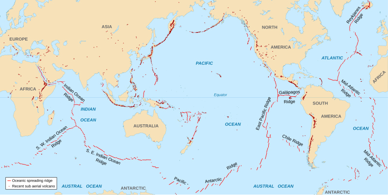
English: World map in English showing the divergent plate boundaries (OSR – Oceanic Spreading Ridges) and recent sub aerial volcanoes.
Français : Carte en anglais des dorsales océaniques et volcans terrestres récents. |
||
| Date | 2006-10, upgraded 2015-09 | ||
| Source |
|
||
| Author | Eric Gaba ( Sting - fr:Sting) | ||
| Permission ( Reusing this file) |
|
||
| Other versions |
|

The Data source link above is now dead. Potentially active/active volcanoes appear to have been mapped if erupted within about last 10,000 odd years with an accuracy of about 50 km (31 mi) onto current basemap. Some active volcanoes are not shown and divergent plate boundaries may have inaccuracies. The map has not been updated since 2015.
Licensing
I, the copyright holder of this work, hereby publish it under the following license:
This file is licensed under the
Creative Commons
Attribution-Share Alike 2.5 Generic license.
- You are free:
- to share – to copy, distribute and transmit the work
- to remix – to adapt the work
- Under the following conditions:
- attribution – You must give appropriate credit, provide a link to the license, and indicate if changes were made. You may do so in any reasonable manner, but not in any way that suggests the licensor endorses you or your use.
- share alike – If you remix, transform, or build upon the material, you must distribute your contributions under the same or compatible license as the original.
File history
Click on a date/time to view the file as it appeared at that time.
| Date/Time | Thumbnail | Dimensions | User | Comment | |
|---|---|---|---|---|---|
| current | 18:51, 6 September 2015 |
| 4,995 × 2,510 (1.29 MB) | Sting | New background map using NGDC WCL data |
| 12:58, 11 November 2007 |
 | 5,000 × 2,525 (913 KB) | Walké | petite correction | |
| 22:10, 23 October 2006 |
 | 5,000 × 2,525 (913 KB) | Sting | OCR name correction; + Red Sea OCR; + continent names | |
| 15:25, 23 October 2006 |
 | 5,000 × 2,525 (898 KB) | Sting | {{Information| |Description=World map in English showing the divergent plate boundaries (OSR – Oceanic Spreading Ridges) and recent sub aerial volcanoes |Source= '''Background map (modified) :''' Image:Tectonic plates (empty).svg created by [[User: |
.svg)
File usage
The following pages on the English Wikipedia use this file (pages on other projects are not listed):
Global file usage
The following other wikis use this file:
- Usage on af.wikipedia.org
- Usage on as.wikipedia.org
- Usage on en.wikiquote.org
- Usage on fi.wikipedia.org
- Usage on fr.wikipedia.org
- Usage on gu.wikipedia.org
- Usage on it.wikibooks.org
- Usage on ja.wikipedia.org
- Usage on ki.wikipedia.org
- Usage on lij.wikipedia.org
- Usage on mk.wikipedia.org
- Usage on ml.wikipedia.org
- Usage on mwl.wikipedia.org
- Usage on pnb.wikipedia.org
- Usage on pt.wikipedia.org
- Usage on rm.wikipedia.org
- Usage on sr.wikipedia.org
- Usage on ta.wikipedia.org
- Usage on te.wikipedia.org
- Usage on tl.wikipedia.org
- Usage on tr.wikipedia.org
- Usage on tt.wikipedia.org
- Usage on tyv.wikipedia.org
- Usage on ur.wikipedia.org
- Usage on vi.wikipedia.org
- Usage on xh.wikipedia.org
Metadata
Size of this PNG preview of this SVG file:
800 × 402 pixels. Other resolutions:
320 × 161 pixels |
640 × 322 pixels |
1,024 × 515 pixels |
1,280 × 643 pixels |
2,560 × 1,286 pixels |
4,995 × 2,510 pixels.
Original file (SVG file, nominally 4,995 × 2,510 pixels, file size: 1.29 MB)
| This is a file from the
Wikimedia Commons. Information from its
description page there is shown below. Commons is a freely licensed media file repository. You can help. |
Summary
| Description |
English: World map in English showing the divergent plate boundaries (OSR – Oceanic Spreading Ridges) and recent sub aerial volcanoes.
Français : Carte en anglais des dorsales océaniques et volcans terrestres récents. |
||
| Date | 2006-10, upgraded 2015-09 | ||
| Source |
|
||
| Author | Eric Gaba ( Sting - fr:Sting) | ||
| Permission ( Reusing this file) |
|
||
| Other versions |
|
The Data source link above is now dead. Potentially active/active volcanoes appear to have been mapped if erupted within about last 10,000 odd years with an accuracy of about 50 km (31 mi) onto current basemap. Some active volcanoes are not shown and divergent plate boundaries may have inaccuracies. The map has not been updated since 2015.
Licensing
I, the copyright holder of this work, hereby publish it under the following license:
This file is licensed under the
Creative Commons
Attribution-Share Alike 2.5 Generic license.
- You are free:
- to share – to copy, distribute and transmit the work
- to remix – to adapt the work
- Under the following conditions:
- attribution – You must give appropriate credit, provide a link to the license, and indicate if changes were made. You may do so in any reasonable manner, but not in any way that suggests the licensor endorses you or your use.
- share alike – If you remix, transform, or build upon the material, you must distribute your contributions under the same or compatible license as the original.
File history
Click on a date/time to view the file as it appeared at that time.
| Date/Time | Thumbnail | Dimensions | User | Comment | |
|---|---|---|---|---|---|
| current | 18:51, 6 September 2015 |
| 4,995 × 2,510 (1.29 MB) | Sting | New background map using NGDC WCL data |
| 12:58, 11 November 2007 |
| 5,000 × 2,525 (913 KB) | Walké | petite correction | |
| 22:10, 23 October 2006 |
| 5,000 × 2,525 (913 KB) | Sting | OCR name correction; + Red Sea OCR; + continent names | |
| 15:25, 23 October 2006 |
| 5,000 × 2,525 (898 KB) | Sting | {{Information| |Description=World map in English showing the divergent plate boundaries (OSR – Oceanic Spreading Ridges) and recent sub aerial volcanoes |Source= '''Background map (modified) :''' Image:Tectonic plates (empty).svg created by [[User: |
File usage
The following pages on the English Wikipedia use this file (pages on other projects are not listed):
Global file usage
The following other wikis use this file:
- Usage on af.wikipedia.org
- Usage on as.wikipedia.org
- Usage on en.wikiquote.org
- Usage on fi.wikipedia.org
- Usage on fr.wikipedia.org
- Usage on gu.wikipedia.org
- Usage on it.wikibooks.org
- Usage on ja.wikipedia.org
- Usage on ki.wikipedia.org
- Usage on lij.wikipedia.org
- Usage on mk.wikipedia.org
- Usage on ml.wikipedia.org
- Usage on mwl.wikipedia.org
- Usage on pnb.wikipedia.org
- Usage on pt.wikipedia.org
- Usage on rm.wikipedia.org
- Usage on sr.wikipedia.org
- Usage on ta.wikipedia.org
- Usage on te.wikipedia.org
- Usage on tl.wikipedia.org
- Usage on tr.wikipedia.org
- Usage on tt.wikipedia.org
- Usage on tyv.wikipedia.org
- Usage on ur.wikipedia.org
- Usage on vi.wikipedia.org
- Usage on xh.wikipedia.org