Photos • Location


Size of this preview:
800 × 533 pixels. Other resolutions:
320 × 213 pixels |
640 × 427 pixels |
1,024 × 683 pixels |
1,280 × 853 pixels |
2,560 × 1,707 pixels |
3,879 × 2,586 pixels.
Original file (3,879 × 2,586 pixels, file size: 2.63 MB, MIME type: image/jpeg)
| This is a file from the
Wikimedia Commons. Information from its
description page there is shown below. Commons is a freely licensed media file repository. You can help. |
|
| This is a featured picture, which means that members of the community have identified it as one of the finest images on the English Wikipedia, adding significantly to its accompanying article. If you have a different image of similar quality, be sure to upload it using the proper free license tag, add it to a relevant article, and nominate it. |
|
| This image was selected as picture of the day on the English Wikipedia for July 16, 2011. |
Summary
| Camera location | | View this and other nearby images on: OpenStreetMap |
|
|---|
| Description |
Afrikaans: Die kleipan by Sossusvlei, wat sowat een keer per dekade deur die Tsauchab-rivier gevul word. Dit is geleë in die sentrale Namib-Naukluft, westelike
Hardap-streek, Namibië
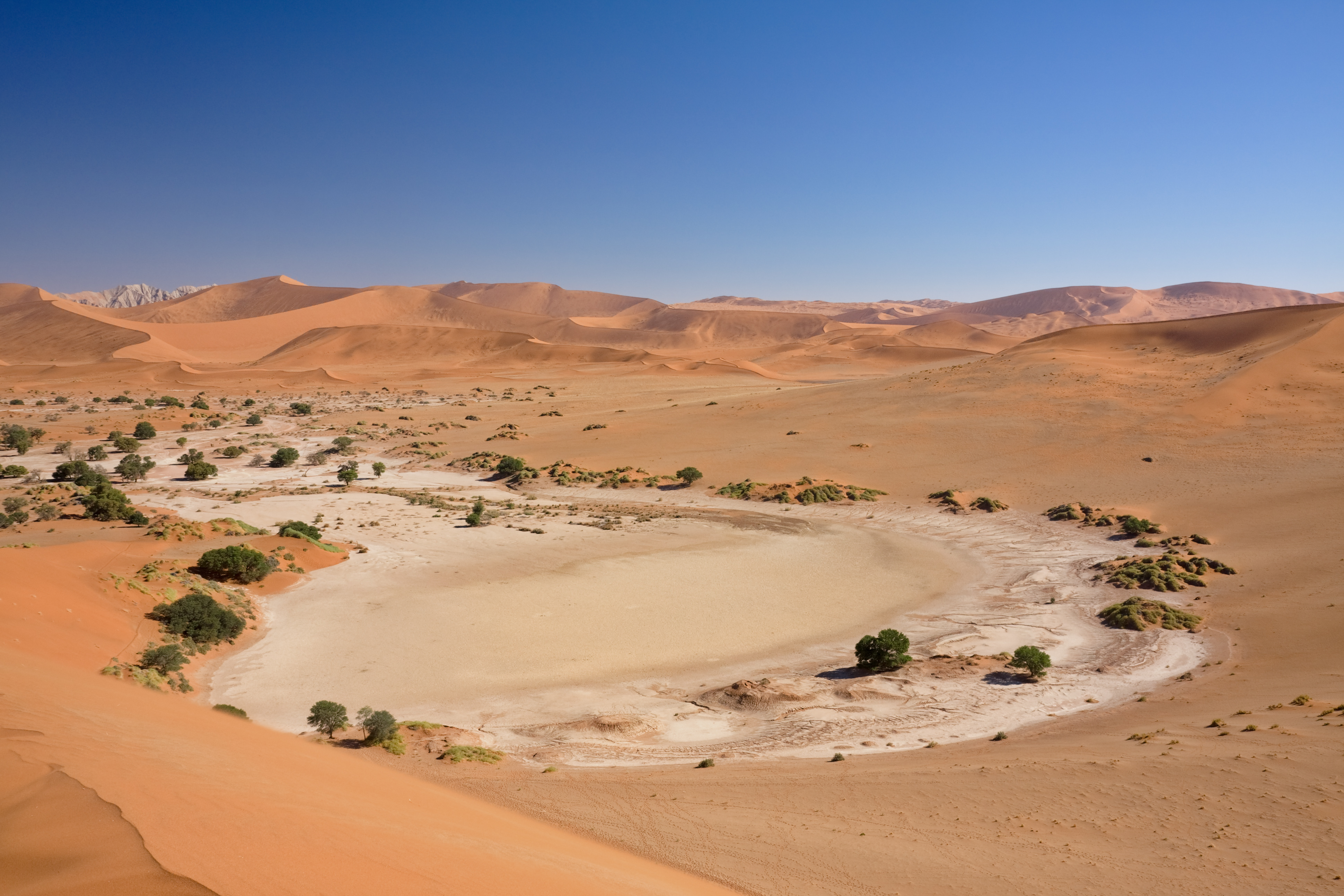
English: The clay pan at
Sossusvlei, which is filled about once in a decade by the Tsauchab river. It is situated in the central
Namib Naukluft, western
Hardap Region, Namibia
|
|||
| Date | ||||
| Source | Own work | |||
| Author | Ikiwaner | |||
| Permission ( Reusing this file) |
|
|||
| Other versions |
Autumn 2006; Winter 2006 
 |

|

File history
Click on a date/time to view the file as it appeared at that time.
| Date/Time | Thumbnail | Dimensions | User | Comment | |
|---|---|---|---|---|---|
| current | 19:25, 19 October 2009 |
| 3,879 × 2,586 (2.63 MB) | Ikiwaner | {{Information |Description={{de|Das Soussusvlei in Namibia}} |Source={{Own}} |Date=siehe Bild-Metadaten |Author= Ikiwaner }} {{GFDL-1.2}} Category:Sossusvlei |
File usage
The following pages on the English Wikipedia use this file (pages on other projects are not listed):
- Dung midden
- List of biogeographic provinces
- Namib
- Sossusvlei
- Talk:Sossusvlei
- User:Daniel Mietchen/Science communication gallery
- User talk:Ikiwaner
- User talk:JJ Harrison/Archive3
- Wikipedia:Featured picture candidates/December-2009
- Wikipedia:Featured picture candidates/File:Sossusvlei.jpg
- Wikipedia:Featured pictures/Places/Landscapes
- Wikipedia:Featured pictures thumbs/21
- Wikipedia:Main Page history/2011 July 16
- Wikipedia:Picture of the day/July 2011
- Wikipedia:WikiProject Protected areas
- Wikipedia:Wikipedia Signpost/2009-12-28/Features and admins
- Wikipedia:Wikipedia Signpost/2009-12-28/SPV
- Wikipedia:Wikipedia Signpost/Single/2009-12-28
- Template:POTD/2011-07-16
Global file usage
The following other wikis use this file:
- Usage on af.wikipedia.org
- Usage on ar.wikipedia.org
- Usage on br.wikipedia.org
- Usage on ckb.wikipedia.org
- Usage on de.wikipedia.org
- Usage on en.wikibooks.org
- Usage on en.wikiversity.org
- Usage on fi.wikipedia.org
- Usage on fr.wikipedia.org
- Usage on gn.wikipedia.org
- Usage on he.wikipedia.org
- Usage on hr.wikipedia.org
- Usage on hu.wikipedia.org
- Usage on id.wikipedia.org
- Usage on lt.wiktionary.org
- Usage on mt.wikipedia.org
- Usage on nl.wikipedia.org
- Usage on pl.wikipedia.org
- Usage on pt.wikipedia.org
- Usage on ru.wiktionary.org
- Usage on sh.wikipedia.org
- Usage on sl.wikipedia.org
- Usage on sw.wikipedia.org
- Usage on uk.wikipedia.org
- Usage on vi.wikipedia.org
- Usage on zh.wikipedia.org
Metadata
Size of this preview:
800 × 533 pixels. Other resolutions:
320 × 213 pixels |
640 × 427 pixels |
1,024 × 683 pixels |
1,280 × 853 pixels |
2,560 × 1,707 pixels |
3,879 × 2,586 pixels.
Original file (3,879 × 2,586 pixels, file size: 2.63 MB, MIME type: image/jpeg)
| This is a file from the
Wikimedia Commons. Information from its
description page there is shown below. Commons is a freely licensed media file repository. You can help. |
|
| This is a featured picture, which means that members of the community have identified it as one of the finest images on the English Wikipedia, adding significantly to its accompanying article. If you have a different image of similar quality, be sure to upload it using the proper free license tag, add it to a relevant article, and nominate it. |
|
| This image was selected as picture of the day on the English Wikipedia for July 16, 2011. |
Summary
| Camera location | | View this and other nearby images on: OpenStreetMap |
|
|---|
| Description |
Afrikaans: Die kleipan by Sossusvlei, wat sowat een keer per dekade deur die Tsauchab-rivier gevul word. Dit is geleë in die sentrale Namib-Naukluft, westelike
Hardap-streek, Namibië
English: The clay pan at
Sossusvlei, which is filled about once in a decade by the Tsauchab river. It is situated in the central
Namib Naukluft, western
Hardap Region, Namibia
|
|||
| Date | ||||
| Source | Own work | |||
| Author | Ikiwaner | |||
| Permission ( Reusing this file) |
|
|||
| Other versions |
Autumn 2006; Winter 2006
|
|
File history
Click on a date/time to view the file as it appeared at that time.
| Date/Time | Thumbnail | Dimensions | User | Comment | |
|---|---|---|---|---|---|
| current | 19:25, 19 October 2009 |
| 3,879 × 2,586 (2.63 MB) | Ikiwaner | {{Information |Description={{de|Das Soussusvlei in Namibia}} |Source={{Own}} |Date=siehe Bild-Metadaten |Author= Ikiwaner }} {{GFDL-1.2}} Category:Sossusvlei |
File usage
The following pages on the English Wikipedia use this file (pages on other projects are not listed):
- Dung midden
- List of biogeographic provinces
- Namib
- Sossusvlei
- Talk:Sossusvlei
- User:Daniel Mietchen/Science communication gallery
- User talk:Ikiwaner
- User talk:JJ Harrison/Archive3
- Wikipedia:Featured picture candidates/December-2009
- Wikipedia:Featured picture candidates/File:Sossusvlei.jpg
- Wikipedia:Featured pictures/Places/Landscapes
- Wikipedia:Featured pictures thumbs/21
- Wikipedia:Main Page history/2011 July 16
- Wikipedia:Picture of the day/July 2011
- Wikipedia:WikiProject Protected areas
- Wikipedia:Wikipedia Signpost/2009-12-28/Features and admins
- Wikipedia:Wikipedia Signpost/2009-12-28/SPV
- Wikipedia:Wikipedia Signpost/Single/2009-12-28
- Template:POTD/2011-07-16
Global file usage
The following other wikis use this file:
- Usage on af.wikipedia.org
- Usage on ar.wikipedia.org
- Usage on br.wikipedia.org
- Usage on ckb.wikipedia.org
- Usage on de.wikipedia.org
- Usage on en.wikibooks.org
- Usage on en.wikiversity.org
- Usage on fi.wikipedia.org
- Usage on fr.wikipedia.org
- Usage on gn.wikipedia.org
- Usage on he.wikipedia.org
- Usage on hr.wikipedia.org
- Usage on hu.wikipedia.org
- Usage on id.wikipedia.org
- Usage on lt.wiktionary.org
- Usage on mt.wikipedia.org
- Usage on nl.wikipedia.org
- Usage on pl.wikipedia.org
- Usage on pt.wikipedia.org
- Usage on ru.wiktionary.org
- Usage on sh.wikipedia.org
- Usage on sl.wikipedia.org
- Usage on sw.wikipedia.org
- Usage on uk.wikipedia.org
- Usage on vi.wikipedia.org
- Usage on zh.wikipedia.org