
Size of this preview:
736 × 599 pixels. Other resolutions:
295 × 240 pixels |
590 × 480 pixels |
943 × 768 pixels |
1,257 × 1,024 pixels |
2,500 × 2,036 pixels.
Original file (2,500 × 2,036 pixels, file size: 1.48 MB, MIME type: image/jpeg)
| This is a file from the
Wikimedia Commons. Information from its
description page there is shown below. Commons is a freely licensed media file repository. You can help. |
Summary
| Description |
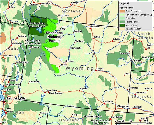
English: Map of Wyoming showing the location of Shoshone National Forest. Created by
Kmf164 using ArcGIS and public domain, U.S. government GIS data sources. |
| Date | |
| Source | Own work |
| Author | Kmf164 |
Licensing
I, the copyright holder of this work, hereby publish it under the following license:
This file is licensed under the
Creative Commons
Attribution-Share Alike 2.5 Generic license.
- You are free:
- to share – to copy, distribute and transmit the work
- to remix – to adapt the work
- Under the following conditions:
- attribution – You must give appropriate credit, provide a link to the license, and indicate if changes were made. You may do so in any reasonable manner, but not in any way that suggests the licensor endorses you or your use.
- share alike – If you remix, transform, or build upon the material, you must distribute your contributions under the same or compatible license as the original.
File history
Click on a date/time to view the file as it appeared at that time.
| Date/Time | Thumbnail | Dimensions | User | Comment | |
|---|---|---|---|---|---|
| current | 08:11, 17 June 2006 |
| 2,500 × 2,036 (1.48 MB) | Aude | |
| 06:58, 17 June 2006 |
 | 2,500 × 2,036 (2 MB) | Aude | ||
| 06:49, 17 June 2006 |
 | 2,500 × 2,036 (3.33 MB) | Aude | ||
| 06:09, 17 June 2006 |
 | 2,500 × 2,036 (1.63 MB) | Aude | Shoshone National Forest locator map. Created by User:Kmf164, using ArcGIS and public domain, U.S. government GIS data sources. ''Note: My software doesn't do .svg (or small file-size .png) exports so well, though at a later date I may provide an .s |
File usage
The following pages on the English Wikipedia use this file (pages on other projects are not listed):
Global file usage
The following other wikis use this file:
- Usage on de.wikipedia.org
- Usage on es.wikipedia.org
- Usage on fa.wikipedia.org
- Usage on fr.wikipedia.org
- Usage on it.wikipedia.org
- Usage on no.wikipedia.org
- Usage on pl.wikipedia.org
- Usage on pt.wikipedia.org
Metadata
Size of this preview:
736 × 599 pixels. Other resolutions:
295 × 240 pixels |
590 × 480 pixels |
943 × 768 pixels |
1,257 × 1,024 pixels |
2,500 × 2,036 pixels.
Original file (2,500 × 2,036 pixels, file size: 1.48 MB, MIME type: image/jpeg)
| This is a file from the
Wikimedia Commons. Information from its
description page there is shown below. Commons is a freely licensed media file repository. You can help. |
Summary
| Description |
English: Map of Wyoming showing the location of Shoshone National Forest. Created by
Kmf164 using ArcGIS and public domain, U.S. government GIS data sources. |
| Date | |
| Source | Own work |
| Author | Kmf164 |
Licensing
I, the copyright holder of this work, hereby publish it under the following license:
This file is licensed under the
Creative Commons
Attribution-Share Alike 2.5 Generic license.
- You are free:
- to share – to copy, distribute and transmit the work
- to remix – to adapt the work
- Under the following conditions:
- attribution – You must give appropriate credit, provide a link to the license, and indicate if changes were made. You may do so in any reasonable manner, but not in any way that suggests the licensor endorses you or your use.
- share alike – If you remix, transform, or build upon the material, you must distribute your contributions under the same or compatible license as the original.
File history
Click on a date/time to view the file as it appeared at that time.
| Date/Time | Thumbnail | Dimensions | User | Comment | |
|---|---|---|---|---|---|
| current | 08:11, 17 June 2006 |
| 2,500 × 2,036 (1.48 MB) | Aude | |
| 06:58, 17 June 2006 |
| 2,500 × 2,036 (2 MB) | Aude | ||
| 06:49, 17 June 2006 |
| 2,500 × 2,036 (3.33 MB) | Aude | ||
| 06:09, 17 June 2006 |
| 2,500 × 2,036 (1.63 MB) | Aude | Shoshone National Forest locator map. Created by User:Kmf164, using ArcGIS and public domain, U.S. government GIS data sources. ''Note: My software doesn't do .svg (or small file-size .png) exports so well, though at a later date I may provide an .s |
File usage
The following pages on the English Wikipedia use this file (pages on other projects are not listed):
Global file usage
The following other wikis use this file:
- Usage on de.wikipedia.org
- Usage on es.wikipedia.org
- Usage on fa.wikipedia.org
- Usage on fr.wikipedia.org
- Usage on it.wikipedia.org
- Usage on no.wikipedia.org
- Usage on pl.wikipedia.org
- Usage on pt.wikipedia.org