
Size of this preview:
398 × 599 pixels. Other resolutions:
159 × 240 pixels |
319 × 480 pixels |
850 × 1,280 pixels.
Original file (850 × 1,280 pixels, file size: 317 KB, MIME type: image/png)
| This is a file from the
Wikimedia Commons. Information from its
description page there is shown below. Commons is a freely licensed media file repository. You can help. |
Summary
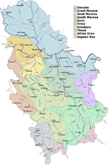
| Description | Detailed map of rivers and main drainage basins in Serbia. |
| Source | Merged from several images published by Hydrometeorological Institute of Serbia. |
| Author | HIS |
Licensing
This image is in the
public domain because according to the Copyright Law of Serbia and Montenegro ("Службени гласник СЦГ", бр. 61/2004), "Work is not copyrighted if the work is:
|
 |
File history
Click on a date/time to view the file as it appeared at that time.
| Date/Time | Thumbnail | Dimensions | User | Comment | |
|---|---|---|---|---|---|
| current | 12:01, 6 November 2006 |
| 850 × 1,280 (317 KB) | Duja | ==Description== Detailed map of rivers and main drainage basins in Serbia ==Licensing== Merged from several images published by Hydrometeorological Institute of Serbia , http://www.hidmet.sr.gov.yu/slike_lat/kv_vode/ [[Category:Maps of rivers of Serbia |
File usage
The following pages on the English Wikipedia use this file (pages on other projects are not listed):
Global file usage
The following other wikis use this file:
- Usage on ast.wikipedia.org
- Usage on bg.wikipedia.org
- Usage on bn.wikipedia.org
- Usage on cs.wikipedia.org
- Usage on de.wikipedia.org
- Usage on es.wikipedia.org
- Usage on fr.wikipedia.org
- Usage on it.wikipedia.org
- Usage on mk.wikipedia.org
- Usage on nl.wikipedia.org
- Usage on nn.wikipedia.org
- Usage on pl.wikipedia.org
- Usage on ro.wikipedia.org
- Usage on ru.wikipedia.org
- Usage on sh.wikipedia.org
- Usage on sr.wikipedia.org
- Јадар (притока Дрине)
- Списак река у Србији
- Јабланица (притока Јужне Мораве)
- Јадар (област)
- Рибница (притока Ибра)
- Лопатањка (река)
- Рибница (притока Колубаре)
- Фидер риболов
- Бешеновачки поток
- Бруја (водени ток)
- Велики поток
- Врањашки поток
- Думбовачки поток
- Ешиковачки поток
- Јеленце
- Каменарски поток
- Каменички поток
- Козарски поток
- Корушка (водени ток)
- Липовачки поток
- Међеш
- Поток Мохарач
- Поток Мутаљ
- Нештински поток
View more global usage of this file.
Size of this preview:
398 × 599 pixels. Other resolutions:
159 × 240 pixels |
319 × 480 pixels |
850 × 1,280 pixels.
Original file (850 × 1,280 pixels, file size: 317 KB, MIME type: image/png)
| This is a file from the
Wikimedia Commons. Information from its
description page there is shown below. Commons is a freely licensed media file repository. You can help. |
Summary
| Description | Detailed map of rivers and main drainage basins in Serbia. |
| Source | Merged from several images published by Hydrometeorological Institute of Serbia. |
| Author | HIS |
Licensing
This image is in the
public domain because according to the Copyright Law of Serbia and Montenegro ("Службени гласник СЦГ", бр. 61/2004), "Work is not copyrighted if the work is:
|
|
File history
Click on a date/time to view the file as it appeared at that time.
| Date/Time | Thumbnail | Dimensions | User | Comment | |
|---|---|---|---|---|---|
| current | 12:01, 6 November 2006 |
| 850 × 1,280 (317 KB) | Duja | ==Description== Detailed map of rivers and main drainage basins in Serbia ==Licensing== Merged from several images published by Hydrometeorological Institute of Serbia , http://www.hidmet.sr.gov.yu/slike_lat/kv_vode/ [[Category:Maps of rivers of Serbia |
File usage
The following pages on the English Wikipedia use this file (pages on other projects are not listed):
Global file usage
The following other wikis use this file:
- Usage on ast.wikipedia.org
- Usage on bg.wikipedia.org
- Usage on bn.wikipedia.org
- Usage on cs.wikipedia.org
- Usage on de.wikipedia.org
- Usage on es.wikipedia.org
- Usage on fr.wikipedia.org
- Usage on it.wikipedia.org
- Usage on mk.wikipedia.org
- Usage on nl.wikipedia.org
- Usage on nn.wikipedia.org
- Usage on pl.wikipedia.org
- Usage on ro.wikipedia.org
- Usage on ru.wikipedia.org
- Usage on sh.wikipedia.org
- Usage on sr.wikipedia.org
- Јадар (притока Дрине)
- Списак река у Србији
- Јабланица (притока Јужне Мораве)
- Јадар (област)
- Рибница (притока Ибра)
- Лопатањка (река)
- Рибница (притока Колубаре)
- Фидер риболов
- Бешеновачки поток
- Бруја (водени ток)
- Велики поток
- Врањашки поток
- Думбовачки поток
- Ешиковачки поток
- Јеленце
- Каменарски поток
- Каменички поток
- Козарски поток
- Корушка (водени ток)
- Липовачки поток
- Међеш
- Поток Мохарач
- Поток Мутаљ
- Нештински поток
View more global usage of this file.