Size of this preview:
800 × 566 pixels. Other resolutions:
320 × 226 pixels |
640 × 452 pixels |
1,024 × 724 pixels |
1,280 × 905 pixels |
2,560 × 1,810 pixels |
3,307 × 2,338 pixels.
Original file (3,307 × 2,338 pixels, file size: 4.81 MB, MIME type: image/png)
| This is a file from the
Wikimedia Commons. Information from its
description page there is shown below. Commons is a freely licensed media file repository. You can help. |
Summary
| Description |
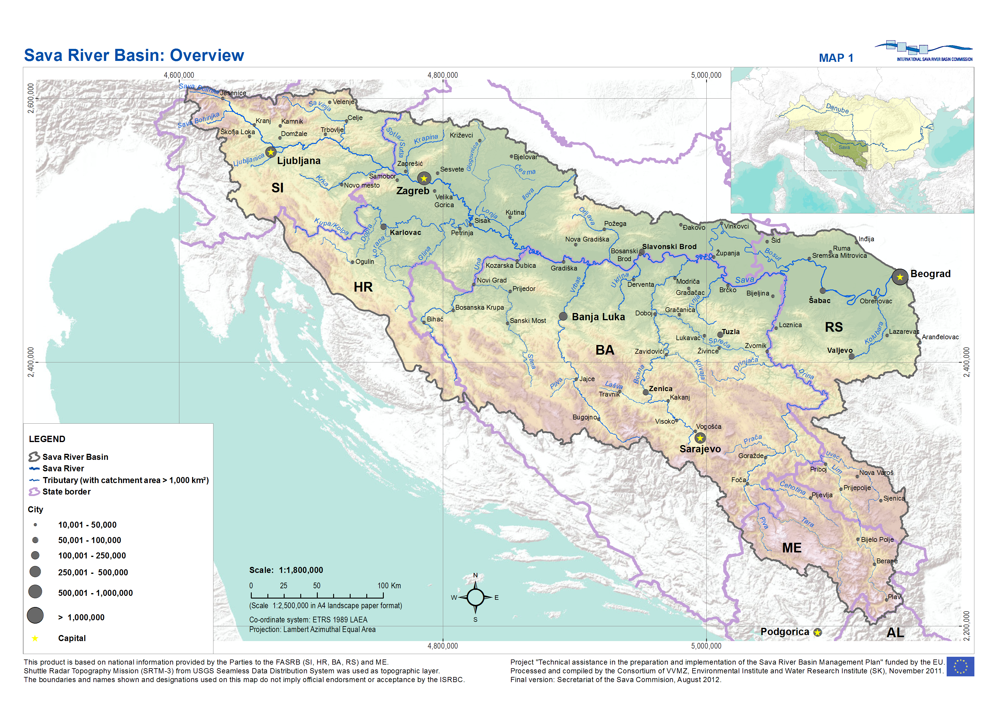
English: Sava River Basin overview |
| Date | |
| Source | Draft Sava River Basin Management Plan, International Sava River Basin Commission, Zagreb, 2013 |
| Author | Secretariat of the International Sava River Basin Commission |
Licensing
I, the copyright holder of this work, hereby publish it under the following license:
This file is licensed under the
Creative Commons
Attribution-Share Alike 3.0 Unported license.
- You are free:
- to share – to copy, distribute and transmit the work
- to remix – to adapt the work
- Under the following conditions:
- attribution – You must give appropriate credit, provide a link to the license, and indicate if changes were made. You may do so in any reasonable manner, but not in any way that suggests the licensor endorses you or your use.
- share alike – If you remix, transform, or build upon the material, you must distribute your contributions under the same or compatible license as the original.
File history
Click on a date/time to view the file as it appeared at that time.
| Date/Time | Thumbnail | Dimensions | User | Comment | |
|---|---|---|---|---|---|
| current | 15:38, 18 March 2014 |
| 3,307 × 2,338 (4.81 MB) | VaKol | Reverted to version as of 15:34, 18 March 2014 |
| 15:37, 18 March 2014 |
 | 3,307 × 2,338 (4.81 MB) | VaKol | Sava River Basin overview map showing proper state borders and country names, unlike previous photo. | |
| 15:34, 18 March 2014 |
 | 3,307 × 2,338 (4.81 MB) | VaKol | Sava River Basin overview map | |
| 14:29, 19 September 2011 |
 | 1,362 × 948 (144 KB) | MirkoS18 |
File usage
The following pages on the English Wikipedia use this file (pages on other projects are not listed):
Global file usage
The following other wikis use this file:
- Usage on af.wikipedia.org
- Usage on az.wikipedia.org
- Usage on be.wikipedia.org
- Usage on bg.wikipedia.org
- Usage on cs.wikipedia.org
- Usage on es.wikipedia.org
- Usage on hr.wikipedia.org
- Usage on hu.wikipedia.org
- Usage on mk.wikipedia.org
- Usage on pl.wikipedia.org
- Usage on sh.wikipedia.org
- Usage on sq.wikipedia.org
- Usage on sr.wikipedia.org
- Usage on uk.wikipedia.org
- Usage on www.wikidata.org
Metadata
Size of this preview:
800 × 566 pixels. Other resolutions:
320 × 226 pixels |
640 × 452 pixels |
1,024 × 724 pixels |
1,280 × 905 pixels |
2,560 × 1,810 pixels |
3,307 × 2,338 pixels.
Original file (3,307 × 2,338 pixels, file size: 4.81 MB, MIME type: image/png)
| This is a file from the
Wikimedia Commons. Information from its
description page there is shown below. Commons is a freely licensed media file repository. You can help. |
Summary
| Description |
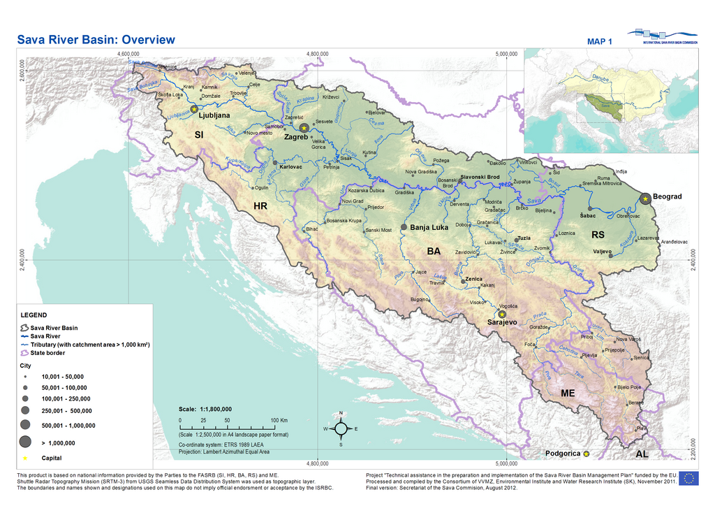
English: Sava River Basin overview |
| Date | |
| Source | Draft Sava River Basin Management Plan, International Sava River Basin Commission, Zagreb, 2013 |
| Author | Secretariat of the International Sava River Basin Commission |
Licensing
I, the copyright holder of this work, hereby publish it under the following license:
This file is licensed under the
Creative Commons
Attribution-Share Alike 3.0 Unported license.
- You are free:
- to share – to copy, distribute and transmit the work
- to remix – to adapt the work
- Under the following conditions:
- attribution – You must give appropriate credit, provide a link to the license, and indicate if changes were made. You may do so in any reasonable manner, but not in any way that suggests the licensor endorses you or your use.
- share alike – If you remix, transform, or build upon the material, you must distribute your contributions under the same or compatible license as the original.
File history
Click on a date/time to view the file as it appeared at that time.
| Date/Time | Thumbnail | Dimensions | User | Comment | |
|---|---|---|---|---|---|
| current | 15:38, 18 March 2014 |
| 3,307 × 2,338 (4.81 MB) | VaKol | Reverted to version as of 15:34, 18 March 2014 |
| 15:37, 18 March 2014 |
| 3,307 × 2,338 (4.81 MB) | VaKol | Sava River Basin overview map showing proper state borders and country names, unlike previous photo. | |
| 15:34, 18 March 2014 |
| 3,307 × 2,338 (4.81 MB) | VaKol | Sava River Basin overview map | |
| 14:29, 19 September 2011 |
| 1,362 × 948 (144 KB) | MirkoS18 |
File usage
The following pages on the English Wikipedia use this file (pages on other projects are not listed):
Global file usage
The following other wikis use this file:
- Usage on af.wikipedia.org
- Usage on az.wikipedia.org
- Usage on be.wikipedia.org
- Usage on bg.wikipedia.org
- Usage on cs.wikipedia.org
- Usage on es.wikipedia.org
- Usage on hr.wikipedia.org
- Usage on hu.wikipedia.org
- Usage on mk.wikipedia.org
- Usage on pl.wikipedia.org
- Usage on sh.wikipedia.org
- Usage on sq.wikipedia.org
- Usage on sr.wikipedia.org
- Usage on uk.wikipedia.org
- Usage on www.wikidata.org