No higher resolution available.
Satellite_image_of_Missouri_River_during_Great_Flood_of_1993.jpg (250 × 250 pixels, file size: 19 KB, MIME type: image/jpeg)
| This is a file from the
Wikimedia Commons. Information from its
description page there is shown below. Commons is a freely licensed media file repository. You can help. |
Summary

|
This file was moved to Wikimedia Commons from en.wikipedia using a bot script. All source information is still present. It requires review. Additionally, there may be errors in any or all of the information fields; information on this file should not be considered reliable and the file should not be used until it has been reviewed and any needed corrections have been made. Once the review has been completed, this template should be removed. For details about this file, see below. Check now! |
| Description |
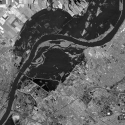
English: Satellite image of the Missouri River at Chesterfield Valley in 1993 |
| Date | |
| Source | http://www.crh.noaa.gov/lsx/?n=1993_flood |
| Author | National Weather Service: National Oceanic and Atmospheric Administration |
Licensing
This image is in the
public domain because it contains materials that originally came from the U.S.
National Oceanic and Atmospheric Administration, taken or made as part of an employee's official duties.
|
Original upload log
Transferred from en.wikipedia to Commons by Ww2censor using CommonsHelper.
The original description page was
here. All following user names refer to en.wikipedia.
- 2004-05-02 01:00 Kevin Saff 250×250× (18977 bytes) Satellite image of Missouri River in 1993
File history
Click on a date/time to view the file as it appeared at that time.
| Date/Time | Thumbnail | Dimensions | User | Comment | |
|---|---|---|---|---|---|
| current | 16:28, 24 July 2013 |
| 250 × 250 (19 KB) | File Upload Bot (Magnus Manske) | Transfered from en.wikipedia by User:Ww2censor using CommonsHelper |
File usage
The following pages on the English Wikipedia use this file (pages on other projects are not listed):
No higher resolution available.
Satellite_image_of_Missouri_River_during_Great_Flood_of_1993.jpg (250 × 250 pixels, file size: 19 KB, MIME type: image/jpeg)
| This is a file from the
Wikimedia Commons. Information from its
description page there is shown below. Commons is a freely licensed media file repository. You can help. |
Summary
|
|
This file was moved to Wikimedia Commons from en.wikipedia using a bot script. All source information is still present. It requires review. Additionally, there may be errors in any or all of the information fields; information on this file should not be considered reliable and the file should not be used until it has been reviewed and any needed corrections have been made. Once the review has been completed, this template should be removed. For details about this file, see below. Check now! |
| Description |
English: Satellite image of the Missouri River at Chesterfield Valley in 1993 |
| Date | |
| Source | http://www.crh.noaa.gov/lsx/?n=1993_flood |
| Author | National Weather Service: National Oceanic and Atmospheric Administration |
Licensing
This image is in the
public domain because it contains materials that originally came from the U.S.
National Oceanic and Atmospheric Administration, taken or made as part of an employee's official duties.
|
Original upload log
Transferred from en.wikipedia to Commons by Ww2censor using CommonsHelper.
The original description page was
here. All following user names refer to en.wikipedia.
- 2004-05-02 01:00 Kevin Saff 250×250× (18977 bytes) Satellite image of Missouri River in 1993
File history
Click on a date/time to view the file as it appeared at that time.
| Date/Time | Thumbnail | Dimensions | User | Comment | |
|---|---|---|---|---|---|
| current | 16:28, 24 July 2013 |
| 250 × 250 (19 KB) | File Upload Bot (Magnus Manske) | Transfered from en.wikipedia by User:Ww2censor using CommonsHelper |
File usage
The following pages on the English Wikipedia use this file (pages on other projects are not listed):