
Size of this preview:
483 × 600 pixels. Other resolutions:
193 × 240 pixels |
387 × 480 pixels |
970 × 1,204 pixels.
Original file (970 × 1,204 pixels, file size: 570 KB, MIME type: image/jpeg)
| This is a file from the
Wikimedia Commons. Information from its
description page there is shown below. Commons is a freely licensed media file repository. You can help. |
Summary
| Description |
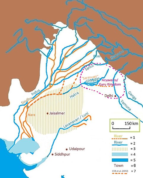
English: Pre-Harappan, Harrapan, and present-day river courses in Indus Valley. Vedic Sarasvati = present-day dried up Gagghar-Hakra. The dried-up Harappan Hakra-course is actually a Sutlej-Yamuna paleochannel (Clift et al. 2012, Singh et al. 2017). 1=ancient river |
| Date | |
| Source |
Derived from File:Sarasvati-ancient-river.jpg Corrections based on: * Clift et al. (2012), "Pb zircon dating evidence for a Pleistocene Sarasvati River and Capture of the Yamuna River", Geology 40(3):212-215, DOI: 10.1130/G32840.1. map * “Tracing the Vedic Saraswati River in the Great Rann of Kachchh”, in Nature Scientific Reports volume 7, Article number: 5476 (2017) [1], 2017 map |
| Author | Joshua Jonathan |
Licensing
I, the copyright holder of this work, hereby publish it under the following license:
This file is licensed under the
Creative Commons
Attribution-Share Alike 4.0 International license.
- You are free:
- to share – to copy, distribute and transmit the work
- to remix – to adapt the work
- Under the following conditions:
- attribution – You must give appropriate credit, provide a link to the license, and indicate if changes were made. You may do so in any reasonable manner, but not in any way that suggests the licensor endorses you or your use.
- share alike – If you remix, transform, or build upon the material, you must distribute your contributions under the same or compatible license as the original.
File history
Click on a date/time to view the file as it appeared at that time.
| Date/Time | Thumbnail | Dimensions | User | Comment | |
|---|---|---|---|---|---|
| current | 05:36, 2 April 2021 |
| 970 × 1,204 (570 KB) | Joshua Jonathan | straight lines instead of dots; corrected paleochannel Ghaggar |
| 09:28, 22 March 2021 |
 | 970 × 1,204 (539 KB) | Joshua Jonathan | Corrected terminal point of Hakra | |
| 08:54, 20 March 2021 |
 | 970 × 1,204 (539 KB) | Joshua Jonathan | legenda | |
| 11:05, 18 March 2021 |
 | 970 × 1,204 (537 KB) | Joshua Jonathan | Extent of Aryavarta/Kuru Kingdom added | |
| 10:33, 18 March 2021 |
 | 970 × 1,204 (516 KB) | Joshua Jonathan | Improved legenda | |
| 09:13, 17 March 2021 |
 | 970 × 1,204 (515 KB) | Joshua Jonathan | Corrected Sutlej name-position | |
| 08:41, 17 March 2021 |
 | 970 × 1,204 (512 KB) | Joshua Jonathan | More from Clift et al. (2012) | |
| 08:19, 17 March 2021 |
 | 970 × 1,204 (498 KB) | Joshua Jonathan | Proposed course | |
| 07:39, 17 March 2021 |
 | 970 × 1,204 (498 KB) | Joshua Jonathan | Moved name upwards | |
| 06:56, 17 March 2021 |
 | 970 × 1,204 (494 KB) | Joshua Jonathan | Uploaded own work with UploadWizard |
File usage
The following pages on the English Wikipedia use this file (pages on other projects are not listed):
Global file usage
The following other wikis use this file:
- Usage on azb.wikipedia.org
- Usage on bn.wikipedia.org
- Usage on ca.wikipedia.org
- Usage on de.wikipedia.org
- Usage on fa.wikipedia.org
- Usage on fr.wikipedia.org
- Usage on hi.wikipedia.org
- Usage on it.wikipedia.org
- Usage on kn.wikipedia.org
- Usage on nl.wikipedia.org
- Usage on pa.wikipedia.org
- Usage on pnb.wikipedia.org
- Usage on pt.wikipedia.org
- Usage on ru.wikipedia.org
- Usage on ta.wikipedia.org
- Usage on th.wikipedia.org
- Usage on ur.wikipedia.org
- Usage on uz.wikipedia.org
- Usage on www.wikidata.org
- Usage on zh.wikipedia.org
Metadata
Size of this preview:
483 × 600 pixels. Other resolutions:
193 × 240 pixels |
387 × 480 pixels |
970 × 1,204 pixels.
Original file (970 × 1,204 pixels, file size: 570 KB, MIME type: image/jpeg)
| This is a file from the
Wikimedia Commons. Information from its
description page there is shown below. Commons is a freely licensed media file repository. You can help. |
Summary
| Description |
English: Pre-Harappan, Harrapan, and present-day river courses in Indus Valley. Vedic Sarasvati = present-day dried up Gagghar-Hakra. The dried-up Harappan Hakra-course is actually a Sutlej-Yamuna paleochannel (Clift et al. 2012, Singh et al. 2017). 1=ancient river |
| Date | |
| Source |
Derived from File:Sarasvati-ancient-river.jpg Corrections based on: * Clift et al. (2012), "Pb zircon dating evidence for a Pleistocene Sarasvati River and Capture of the Yamuna River", Geology 40(3):212-215, DOI: 10.1130/G32840.1. map * “Tracing the Vedic Saraswati River in the Great Rann of Kachchh”, in Nature Scientific Reports volume 7, Article number: 5476 (2017) [1], 2017 map |
| Author | Joshua Jonathan |
Licensing
I, the copyright holder of this work, hereby publish it under the following license:
This file is licensed under the
Creative Commons
Attribution-Share Alike 4.0 International license.
- You are free:
- to share – to copy, distribute and transmit the work
- to remix – to adapt the work
- Under the following conditions:
- attribution – You must give appropriate credit, provide a link to the license, and indicate if changes were made. You may do so in any reasonable manner, but not in any way that suggests the licensor endorses you or your use.
- share alike – If you remix, transform, or build upon the material, you must distribute your contributions under the same or compatible license as the original.
File history
Click on a date/time to view the file as it appeared at that time.
| Date/Time | Thumbnail | Dimensions | User | Comment | |
|---|---|---|---|---|---|
| current | 05:36, 2 April 2021 |
| 970 × 1,204 (570 KB) | Joshua Jonathan | straight lines instead of dots; corrected paleochannel Ghaggar |
| 09:28, 22 March 2021 |
| 970 × 1,204 (539 KB) | Joshua Jonathan | Corrected terminal point of Hakra | |
| 08:54, 20 March 2021 |
| 970 × 1,204 (539 KB) | Joshua Jonathan | legenda | |
| 11:05, 18 March 2021 |
| 970 × 1,204 (537 KB) | Joshua Jonathan | Extent of Aryavarta/Kuru Kingdom added | |
| 10:33, 18 March 2021 |
| 970 × 1,204 (516 KB) | Joshua Jonathan | Improved legenda | |
| 09:13, 17 March 2021 |
| 970 × 1,204 (515 KB) | Joshua Jonathan | Corrected Sutlej name-position | |
| 08:41, 17 March 2021 |
| 970 × 1,204 (512 KB) | Joshua Jonathan | More from Clift et al. (2012) | |
| 08:19, 17 March 2021 |
| 970 × 1,204 (498 KB) | Joshua Jonathan | Proposed course | |
| 07:39, 17 March 2021 |
| 970 × 1,204 (498 KB) | Joshua Jonathan | Moved name upwards | |
| 06:56, 17 March 2021 |
| 970 × 1,204 (494 KB) | Joshua Jonathan | Uploaded own work with UploadWizard |
File usage
The following pages on the English Wikipedia use this file (pages on other projects are not listed):
Global file usage
The following other wikis use this file:
- Usage on azb.wikipedia.org
- Usage on bn.wikipedia.org
- Usage on ca.wikipedia.org
- Usage on de.wikipedia.org
- Usage on fa.wikipedia.org
- Usage on fr.wikipedia.org
- Usage on hi.wikipedia.org
- Usage on it.wikipedia.org
- Usage on kn.wikipedia.org
- Usage on nl.wikipedia.org
- Usage on pa.wikipedia.org
- Usage on pnb.wikipedia.org
- Usage on pt.wikipedia.org
- Usage on ru.wikipedia.org
- Usage on ta.wikipedia.org
- Usage on th.wikipedia.org
- Usage on ur.wikipedia.org
- Usage on uz.wikipedia.org
- Usage on www.wikidata.org
- Usage on zh.wikipedia.org