
Size of this preview:
800 × 412 pixels. Other resolutions:
320 × 165 pixels |
640 × 330 pixels |
1,024 × 527 pixels |
1,788 × 921 pixels.
Original file (1,788 × 921 pixels, file size: 2.06 MB, MIME type: image/png)
| This is a file from the
Wikimedia Commons. Information from its
description page there is shown below. Commons is a freely licensed media file repository. You can help. |
Summary
| Description |
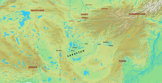
English: Map of Sakastan and its surroundings during the Sasanian era.
|
| Source | Own work |
| Author | HistoryofIran |
Licensing
I, the copyright holder of this work, hereby publish it under the following license:
This file is licensed under the
Creative Commons
Attribution-Share Alike 3.0 Unported license.
- You are free:
- to share – to copy, distribute and transmit the work
- to remix – to adapt the work
- Under the following conditions:
- attribution – You must give appropriate credit, provide a link to the license, and indicate if changes were made. You may do so in any reasonable manner, but not in any way that suggests the licensor endorses you or your use.
- share alike – If you remix, transform, or build upon the material, you must distribute your contributions under the same or compatible license as the original.
File history
Click on a date/time to view the file as it appeared at that time.
| Date/Time | Thumbnail | Dimensions | User | Comment | |
|---|---|---|---|---|---|
| current | 16:31, 1 January 2016 |
| 1,788 × 921 (2.06 MB) | HistoryofIran | . |
| 18:38, 28 December 2015 |
 | 1,788 × 921 (2.06 MB) | HistoryofIran | {{subst:Upload marker added by en.wp UW}} {{Information |Description = {{en|Map of Sakastan and its surroundings during the Sasanian era. *Map taken from [http://www2.demis.nl/ DEMIS Mapserver], which is public domain, the rest is self-made.}}|source={... |
File usage
The following pages on the English Wikipedia use this file (pages on other projects are not listed):
Global file usage
The following other wikis use this file:
- Usage on arz.wikipedia.org
- Usage on azb.wikipedia.org
- Usage on ba.wikipedia.org
- Usage on bn.wikipedia.org
- Usage on de.wikipedia.org
- Usage on es.wikipedia.org
- Usage on incubator.wikimedia.org
- Usage on ru.wikipedia.org
- Usage on zh.wikipedia.org
Metadata
Size of this preview:
800 × 412 pixels. Other resolutions:
320 × 165 pixels |
640 × 330 pixels |
1,024 × 527 pixels |
1,788 × 921 pixels.
Original file (1,788 × 921 pixels, file size: 2.06 MB, MIME type: image/png)
| This is a file from the
Wikimedia Commons. Information from its
description page there is shown below. Commons is a freely licensed media file repository. You can help. |
Summary
| Description |
English: Map of Sakastan and its surroundings during the Sasanian era.
|
| Source | Own work |
| Author | HistoryofIran |
Licensing
I, the copyright holder of this work, hereby publish it under the following license:
This file is licensed under the
Creative Commons
Attribution-Share Alike 3.0 Unported license.
- You are free:
- to share – to copy, distribute and transmit the work
- to remix – to adapt the work
- Under the following conditions:
- attribution – You must give appropriate credit, provide a link to the license, and indicate if changes were made. You may do so in any reasonable manner, but not in any way that suggests the licensor endorses you or your use.
- share alike – If you remix, transform, or build upon the material, you must distribute your contributions under the same or compatible license as the original.
File history
Click on a date/time to view the file as it appeared at that time.
| Date/Time | Thumbnail | Dimensions | User | Comment | |
|---|---|---|---|---|---|
| current | 16:31, 1 January 2016 |
| 1,788 × 921 (2.06 MB) | HistoryofIran | . |
| 18:38, 28 December 2015 |
| 1,788 × 921 (2.06 MB) | HistoryofIran | {{subst:Upload marker added by en.wp UW}} {{Information |Description = {{en|Map of Sakastan and its surroundings during the Sasanian era. *Map taken from [http://www2.demis.nl/ DEMIS Mapserver], which is public domain, the rest is self-made.}}|source={... |
File usage
The following pages on the English Wikipedia use this file (pages on other projects are not listed):
Global file usage
The following other wikis use this file:
- Usage on arz.wikipedia.org
- Usage on azb.wikipedia.org
- Usage on ba.wikipedia.org
- Usage on bn.wikipedia.org
- Usage on de.wikipedia.org
- Usage on es.wikipedia.org
- Usage on incubator.wikimedia.org
- Usage on ru.wikipedia.org
- Usage on zh.wikipedia.org