
Size of this preview:
596 × 600 pixels. Other resolutions:
238 × 240 pixels |
477 × 480 pixels |
763 × 768 pixels |
1,017 × 1,024 pixels |
1,500 × 1,510 pixels.
Original file (1,500 × 1,510 pixels, file size: 3.14 MB, MIME type: image/png)
| This is a file from the
Wikimedia Commons. Information from its
description page there is shown below. Commons is a freely licensed media file repository. You can help. |
Summary
| Description |
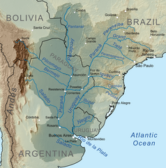
English: Map showing the
Río de la Plata drainage basin including major tributaries and cities.
Español: Mapa que muestra la cuenca de drenaje del
Río de la Plata, incluidos los principales afluentes y ciudades. |
| Date | |
| Source | Own work, Elevation data from SRTM, drainage basin from GTOPO [1], all other features from Vector Map. |
| Author | Kmusser |
| Other versions |
|


Licensing
I, the copyright holder of this work, hereby publish it under the following license:
This file is licensed under the
Creative Commons
Attribution-Share Alike 3.0 Unported license.
- You are free:
- to share – to copy, distribute and transmit the work
- to remix – to adapt the work
- Under the following conditions:
- attribution – You must give appropriate credit, provide a link to the license, and indicate if changes were made. You may do so in any reasonable manner, but not in any way that suggests the licensor endorses you or your use.
- share alike – If you remix, transform, or build upon the material, you must distribute your contributions under the same or compatible license as the original.
File history
Click on a date/time to view the file as it appeared at that time.
| Date/Time | Thumbnail | Dimensions | User | Comment | |
|---|---|---|---|---|---|
| current | 16:43, 6 October 2010 |
| 1,500 × 1,510 (3.14 MB) | Kmusser | == Summary == {{Information |Description=Map showing the Río de la Plata drainage basin including major tributaries and cities. |Source={{own}}, Elevation data from SRTM, drainage basin from |
File usage
The following pages on the English Wikipedia use this file (pages on other projects are not listed):
- Aleixo Garcia
- Bermejo River
- Canoas River (Santa Catarina)
- First Treaty of San Ildefonso
- Gaucho
- Guaycuru peoples
- Hypostomus luteus
- Ibicuí River
- Iguazu River
- Integrated urban water management in Buenos Aires, Argentina
- International waters
- Itatín
- List of tributaries of the Río de la Plata
- Mbayá
- Mercosur Waterways diplomatic crisis
- Paranapanema River
- Paranaíba River
- Paraná River
- Pelotas River
- Pilcomayo River
- Platine Wars
- Río Negro (Uruguay)
- Río de la Plata
- Río de la Plata Basin
- Salado River (Argentina)
- Salado River (Buenos Aires)
- Sierra de la Plata
- Tietê River
- Treaty of El Pardo (1778)
- Treaty of the Triple Alliance
- Uruguay River
- User:Accuratelibrarian/sandbox
- User:Kmusser/Images
- User:Ttocserp/gaucho
Global file usage
The following other wikis use this file:
- Usage on af.wikipedia.org
- Usage on ar.wikipedia.org
- Usage on ast.wikipedia.org
- Usage on azb.wikipedia.org
- Usage on az.wikipedia.org
- Usage on be.wikipedia.org
- Usage on bg.wikipedia.org
- Usage on bh.wikipedia.org
- Usage on bn.wikipedia.org
- Usage on br.wikipedia.org
- Usage on bs.wikipedia.org
- Usage on ca.wikipedia.org
- Usage on ceb.wikipedia.org
- Usage on cs.wikipedia.org
View more global usage of this file.
Size of this preview:
596 × 600 pixels. Other resolutions:
238 × 240 pixels |
477 × 480 pixels |
763 × 768 pixels |
1,017 × 1,024 pixels |
1,500 × 1,510 pixels.
Original file (1,500 × 1,510 pixels, file size: 3.14 MB, MIME type: image/png)
| This is a file from the
Wikimedia Commons. Information from its
description page there is shown below. Commons is a freely licensed media file repository. You can help. |
Summary
| Description |
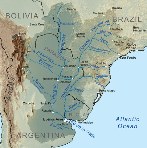
English: Map showing the
Río de la Plata drainage basin including major tributaries and cities.
Español: Mapa que muestra la cuenca de drenaje del
Río de la Plata, incluidos los principales afluentes y ciudades. |
| Date | |
| Source | Own work, Elevation data from SRTM, drainage basin from GTOPO [1], all other features from Vector Map. |
| Author | Kmusser |
| Other versions |
|
Licensing
I, the copyright holder of this work, hereby publish it under the following license:
This file is licensed under the
Creative Commons
Attribution-Share Alike 3.0 Unported license.
- You are free:
- to share – to copy, distribute and transmit the work
- to remix – to adapt the work
- Under the following conditions:
- attribution – You must give appropriate credit, provide a link to the license, and indicate if changes were made. You may do so in any reasonable manner, but not in any way that suggests the licensor endorses you or your use.
- share alike – If you remix, transform, or build upon the material, you must distribute your contributions under the same or compatible license as the original.
File history
Click on a date/time to view the file as it appeared at that time.
| Date/Time | Thumbnail | Dimensions | User | Comment | |
|---|---|---|---|---|---|
| current | 16:43, 6 October 2010 |
| 1,500 × 1,510 (3.14 MB) | Kmusser | == Summary == {{Information |Description=Map showing the Río de la Plata drainage basin including major tributaries and cities. |Source={{own}}, Elevation data from SRTM, drainage basin from |
File usage
The following pages on the English Wikipedia use this file (pages on other projects are not listed):
- Aleixo Garcia
- Bermejo River
- Canoas River (Santa Catarina)
- First Treaty of San Ildefonso
- Gaucho
- Guaycuru peoples
- Hypostomus luteus
- Ibicuí River
- Iguazu River
- Integrated urban water management in Buenos Aires, Argentina
- International waters
- Itatín
- List of tributaries of the Río de la Plata
- Mbayá
- Mercosur Waterways diplomatic crisis
- Paranapanema River
- Paranaíba River
- Paraná River
- Pelotas River
- Pilcomayo River
- Platine Wars
- Río Negro (Uruguay)
- Río de la Plata
- Río de la Plata Basin
- Salado River (Argentina)
- Salado River (Buenos Aires)
- Sierra de la Plata
- Tietê River
- Treaty of El Pardo (1778)
- Treaty of the Triple Alliance
- Uruguay River
- User:Accuratelibrarian/sandbox
- User:Kmusser/Images
- User:Ttocserp/gaucho
Global file usage
The following other wikis use this file:
- Usage on af.wikipedia.org
- Usage on ar.wikipedia.org
- Usage on ast.wikipedia.org
- Usage on azb.wikipedia.org
- Usage on az.wikipedia.org
- Usage on be.wikipedia.org
- Usage on bg.wikipedia.org
- Usage on bh.wikipedia.org
- Usage on bn.wikipedia.org
- Usage on br.wikipedia.org
- Usage on bs.wikipedia.org
- Usage on ca.wikipedia.org
- Usage on ceb.wikipedia.org
- Usage on cs.wikipedia.org
View more global usage of this file.