Size of this preview:
398 × 600 pixels. Other resolutions:
159 × 240 pixels |
318 × 480 pixels |
796 × 1,200 pixels.
Original file (796 × 1,200 pixels, file size: 165 KB, MIME type: image/png)
| This is a file from the
Wikimedia Commons. Information from its
description page there is shown below. Commons is a freely licensed media file repository. You can help. |
| Description |
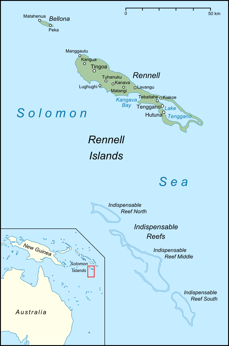
Deutsch: Karte der Inseln Rennell und Bellona, sowie der Indispensable Reefs im Süden der Salomonen |
| Date | |
| Source |
own work, used: |
| Author | Lencer |

|
This map has been made or improved in the German
Kartenwerkstatt (Map Lab). You can
propose maps to improve as well.
|
This file is licensed under the
Creative Commons
Attribution-Share Alike 3.0 Unported license.
- You are free:
- to share – to copy, distribute and transmit the work
- to remix – to adapt the work
- Under the following conditions:
- attribution – You must give appropriate credit, provide a link to the license, and indicate if changes were made. You may do so in any reasonable manner, but not in any way that suggests the licensor endorses you or your use.
- share alike – If you remix, transform, or build upon the material, you must distribute your contributions under the same or compatible license as the original.
File history
Click on a date/time to view the file as it appeared at that time.
| Date/Time | Thumbnail | Dimensions | User | Comment | |
|---|---|---|---|---|---|
| current | 11:25, 9 July 2009 |
| 796 × 1,200 (165 KB) | Lencer | fix solomon islands |
| 11:09, 9 July 2009 |
 | 796 × 1,200 (165 KB) | Lencer | new minimap | |
| 16:18, 8 July 2009 |
 | 796 × 1,200 (148 KB) | Lencer | add some text | |
| 13:54, 8 July 2009 |
 | 796 × 1,200 (135 KB) | Lencer | {{Information| |Description={{de|Karte der Inseln Rennell und Bellona, sowie der Indispensable Reefs im Süden der Salomonen}} |Source=own work, used: * Google Earth * Solomon Islands location map.svg by [[User:N |
File usage
The following pages on the English Wikipedia use this file (pages on other projects are not listed):
Global file usage
The following other wikis use this file:
- Usage on ace.wikipedia.org
- Usage on arz.wikipedia.org
- Usage on ast.wikipedia.org
- Usage on bg.wikipedia.org
- Usage on ca.wikipedia.org
- Usage on ceb.wikipedia.org
- Usage on cy.wikipedia.org
- Usage on da.wikipedia.org
- Usage on de.wikipedia.org
- Usage on eo.wikipedia.org
- Usage on es.wikipedia.org
- Usage on eu.wikipedia.org
- Usage on fa.wikipedia.org
- Usage on fi.wikipedia.org
- Usage on fr.wikipedia.org
- Usage on gl.wikipedia.org
- Usage on hr.wikipedia.org
- Usage on it.wikipedia.org
- Usage on ja.wikipedia.org
- Usage on ka.wikipedia.org
- Usage on ko.wikipedia.org
- Usage on lt.wikipedia.org
- Usage on mrj.wikipedia.org
- Usage on nl.wikipedia.org
- Usage on pt.wikipedia.org
View more global usage of this file.
Size of this preview:
398 × 600 pixels. Other resolutions:
159 × 240 pixels |
318 × 480 pixels |
796 × 1,200 pixels.
Original file (796 × 1,200 pixels, file size: 165 KB, MIME type: image/png)
| This is a file from the
Wikimedia Commons. Information from its
description page there is shown below. Commons is a freely licensed media file repository. You can help. |
| Description |
Deutsch: Karte der Inseln Rennell und Bellona, sowie der Indispensable Reefs im Süden der Salomonen |
| Date | |
| Source |
own work, used: |
| Author | Lencer |
|
|
This map has been made or improved in the German
Kartenwerkstatt (Map Lab). You can
propose maps to improve as well.
|
This file is licensed under the
Creative Commons
Attribution-Share Alike 3.0 Unported license.
- You are free:
- to share – to copy, distribute and transmit the work
- to remix – to adapt the work
- Under the following conditions:
- attribution – You must give appropriate credit, provide a link to the license, and indicate if changes were made. You may do so in any reasonable manner, but not in any way that suggests the licensor endorses you or your use.
- share alike – If you remix, transform, or build upon the material, you must distribute your contributions under the same or compatible license as the original.
File history
Click on a date/time to view the file as it appeared at that time.
| Date/Time | Thumbnail | Dimensions | User | Comment | |
|---|---|---|---|---|---|
| current | 11:25, 9 July 2009 |
| 796 × 1,200 (165 KB) | Lencer | fix solomon islands |
| 11:09, 9 July 2009 |
| 796 × 1,200 (165 KB) | Lencer | new minimap | |
| 16:18, 8 July 2009 |
| 796 × 1,200 (148 KB) | Lencer | add some text | |
| 13:54, 8 July 2009 |
| 796 × 1,200 (135 KB) | Lencer | {{Information| |Description={{de|Karte der Inseln Rennell und Bellona, sowie der Indispensable Reefs im Süden der Salomonen}} |Source=own work, used: * Google Earth * Solomon Islands location map.svg by [[User:N |
File usage
The following pages on the English Wikipedia use this file (pages on other projects are not listed):
Global file usage
The following other wikis use this file:
- Usage on ace.wikipedia.org
- Usage on arz.wikipedia.org
- Usage on ast.wikipedia.org
- Usage on bg.wikipedia.org
- Usage on ca.wikipedia.org
- Usage on ceb.wikipedia.org
- Usage on cy.wikipedia.org
- Usage on da.wikipedia.org
- Usage on de.wikipedia.org
- Usage on eo.wikipedia.org
- Usage on es.wikipedia.org
- Usage on eu.wikipedia.org
- Usage on fa.wikipedia.org
- Usage on fi.wikipedia.org
- Usage on fr.wikipedia.org
- Usage on gl.wikipedia.org
- Usage on hr.wikipedia.org
- Usage on it.wikipedia.org
- Usage on ja.wikipedia.org
- Usage on ka.wikipedia.org
- Usage on ko.wikipedia.org
- Usage on lt.wikipedia.org
- Usage on mrj.wikipedia.org
- Usage on nl.wikipedia.org
- Usage on pt.wikipedia.org
View more global usage of this file.