
Size of this PNG preview of this SVG file:
479 × 583 pixels. Other resolutions:
197 × 240 pixels |
394 × 480 pixels |
631 × 768 pixels |
841 × 1,024 pixels |
1,683 × 2,048 pixels.
Original file (SVG file, nominally 479 × 583 pixels, file size: 3.42 MB)
| This is a file from the
Wikimedia Commons. Information from its
description page there is shown below. Commons is a freely licensed media file repository. You can help. |
Summary
| Description |
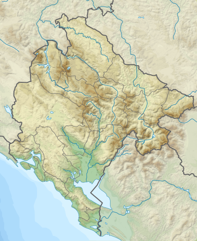
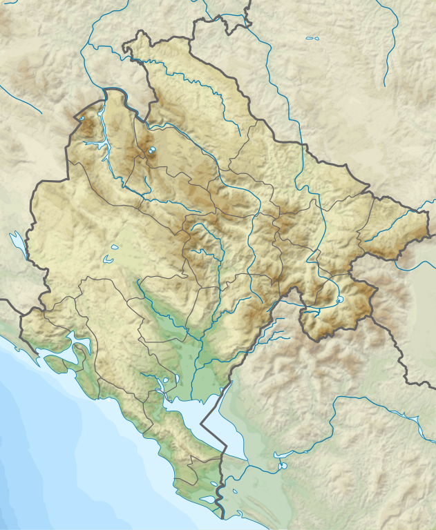
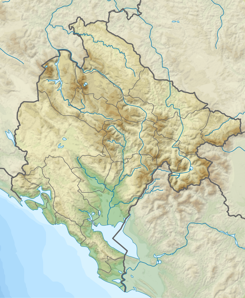
English: Relief Map of Montenegro
Српски / srpski: Топографска мапа Црне Горе |
| Date | |
| Source | http://sr.wikipedia.org/wiki/%D0%94%D0%B0%D1%82%D0%BE%D1%82%D0%B5%D0%BA%D0%B0:Dinaric_Alps_map_sr.svg |
| Author |
|
Licensing
This file is licensed under the
Creative Commons
Attribution-Share Alike 3.0 Unported license.
- You are free:
- to share – to copy, distribute and transmit the work
- to remix – to adapt the work
- Under the following conditions:
- attribution – You must give appropriate credit, provide a link to the license, and indicate if changes were made. You may do so in any reasonable manner, but not in any way that suggests the licensor endorses you or your use.
- share alike – If you remix, transform, or build upon the material, you must distribute your contributions under the same or compatible license as the original.
File history
Click on a date/time to view the file as it appeared at that time.
| Date/Time | Thumbnail | Dimensions | User | Comment | |
|---|---|---|---|---|---|
| current | 00:38, 25 July 2020 |
| 479 × 583 (3.42 MB) | Santasa99 | + the river Ćehotina. |
| 17:35, 24 July 2020 |
 | 479 × 583 (3.41 MB) | Santasa99 | Improved with addition of the missing features: rivers, lakes, and borders. | |
| 11:34, 18 March 2012 |
 | 479 × 583 (3.33 MB) | Ivan25 | borders. | |
| 13:15, 17 March 2012 |
 | 479 × 583 (3.29 MB) | Ivan25 |
File usage
The following pages on the English Wikipedia use this file (pages on other projects are not listed):
- 1979 Montenegro earthquake
- Accursed Mountains
- Battle on Vrtijeljka
- Bijela gora
- Bjelasica
- Black Lake (Montenegro)
- Bobotov Kuk
- Bogiçaj
- Borovi do
- Brda (Montenegro)
- Budoš Limestone
- Debeli Namet
- Dobra Kolata
- Durmitor
- Fortifications of Kotor
- Garač
- Great Lake of Buni Jezerce
- Hajla
- Hum (Pešter)
- Immaculate Conception Cathedral, Bar
- Kamenik (mountain)
- Komovi
- Kovač planina
- Lake Biograd
- Lake Grahovo
- Lake Piva
- Lake Plav
- Lake Rujište
- Lake Skadar
- Lake Sylbicë
- Lake Visitor
- Lake Šas
- List of fossiliferous stratigraphic units in Montenegro
- List of settlements in Illyria
- Ljubišnja
- Lovćen
- Maganik
- Maglić (mountain)
- Maja e Rosit
- Maja e Thatë
- Mongol invasion of Bulgaria and Serbia
- Montenegrin Navy
- Mountain Maglić
- Mratinje Dam
- National Museum of Montenegro
- Natural and Culturo-Historical Region of Kotor
- Njegoš Mountain
- Opuvani do
- Orlov krš
- Podgorica
- Porphyrit-Hornstein Formation
- Reovačka greda
- Rumija
- Sinjajevina
- Sokol Fortress (Piva)
- Stožina
- Trekufiri
- Trnovačko Lake
- Veliki Kabao
- Visitor (mountain)
- Vojnik (mountain)
- Vrmac
- Wengener Schichten Formation
- Zla Kolata
- Žljeb
- User:Noclador/sandbox/Royal Italian Army - Army Group East - September 1943
- User:Ty654/List of earthquakes from 1975-1979 exceeding magnitude 6+
- Module:Location map/data/Montenegro
- Module:Location map/data/Montenegro/doc
Global file usage
The following other wikis use this file:
- Usage on ar.wikipedia.org
- Usage on ast.wikipedia.org
- Usage on az.wikipedia.org
- Usage on be.wikipedia.org
- Usage on bn.wikipedia.org
- Usage on bs.wikipedia.org
- Usage on ca.wikipedia.org
- Usage on ceb.wikipedia.org
- Usage on ce.wikipedia.org
- Usage on da.wikipedia.org
- Usage on de.wikipedia.org
- Usage on de.wikivoyage.org
- Usage on el.wikipedia.org
- Usage on eo.wikipedia.org
- Usage on es.wikipedia.org
View more global usage of this file.
Metadata
Size of this PNG preview of this SVG file:
479 × 583 pixels. Other resolutions:
197 × 240 pixels |
394 × 480 pixels |
631 × 768 pixels |
841 × 1,024 pixels |
1,683 × 2,048 pixels.
Original file (SVG file, nominally 479 × 583 pixels, file size: 3.42 MB)
| This is a file from the
Wikimedia Commons. Information from its
description page there is shown below. Commons is a freely licensed media file repository. You can help. |
Summary
| Description |
English: Relief Map of Montenegro
Српски / srpski: Топографска мапа Црне Горе |
| Date | |
| Source | http://sr.wikipedia.org/wiki/%D0%94%D0%B0%D1%82%D0%BE%D1%82%D0%B5%D0%BA%D0%B0:Dinaric_Alps_map_sr.svg |
| Author |
|
Licensing
This file is licensed under the
Creative Commons
Attribution-Share Alike 3.0 Unported license.
- You are free:
- to share – to copy, distribute and transmit the work
- to remix – to adapt the work
- Under the following conditions:
- attribution – You must give appropriate credit, provide a link to the license, and indicate if changes were made. You may do so in any reasonable manner, but not in any way that suggests the licensor endorses you or your use.
- share alike – If you remix, transform, or build upon the material, you must distribute your contributions under the same or compatible license as the original.
File history
Click on a date/time to view the file as it appeared at that time.
| Date/Time | Thumbnail | Dimensions | User | Comment | |
|---|---|---|---|---|---|
| current | 00:38, 25 July 2020 |
| 479 × 583 (3.42 MB) | Santasa99 | + the river Ćehotina. |
| 17:35, 24 July 2020 |
| 479 × 583 (3.41 MB) | Santasa99 | Improved with addition of the missing features: rivers, lakes, and borders. | |
| 11:34, 18 March 2012 |
| 479 × 583 (3.33 MB) | Ivan25 | borders. | |
| 13:15, 17 March 2012 |
| 479 × 583 (3.29 MB) | Ivan25 |
File usage
The following pages on the English Wikipedia use this file (pages on other projects are not listed):
- 1979 Montenegro earthquake
- Accursed Mountains
- Battle on Vrtijeljka
- Bijela gora
- Bjelasica
- Black Lake (Montenegro)
- Bobotov Kuk
- Bogiçaj
- Borovi do
- Brda (Montenegro)
- Budoš Limestone
- Debeli Namet
- Dobra Kolata
- Durmitor
- Fortifications of Kotor
- Garač
- Great Lake of Buni Jezerce
- Hajla
- Hum (Pešter)
- Immaculate Conception Cathedral, Bar
- Kamenik (mountain)
- Komovi
- Kovač planina
- Lake Biograd
- Lake Grahovo
- Lake Piva
- Lake Plav
- Lake Rujište
- Lake Skadar
- Lake Sylbicë
- Lake Visitor
- Lake Šas
- List of fossiliferous stratigraphic units in Montenegro
- List of settlements in Illyria
- Ljubišnja
- Lovćen
- Maganik
- Maglić (mountain)
- Maja e Rosit
- Maja e Thatë
- Mongol invasion of Bulgaria and Serbia
- Montenegrin Navy
- Mountain Maglić
- Mratinje Dam
- National Museum of Montenegro
- Natural and Culturo-Historical Region of Kotor
- Njegoš Mountain
- Opuvani do
- Orlov krš
- Podgorica
- Porphyrit-Hornstein Formation
- Reovačka greda
- Rumija
- Sinjajevina
- Sokol Fortress (Piva)
- Stožina
- Trekufiri
- Trnovačko Lake
- Veliki Kabao
- Visitor (mountain)
- Vojnik (mountain)
- Vrmac
- Wengener Schichten Formation
- Zla Kolata
- Žljeb
- User:Noclador/sandbox/Royal Italian Army - Army Group East - September 1943
- User:Ty654/List of earthquakes from 1975-1979 exceeding magnitude 6+
- Module:Location map/data/Montenegro
- Module:Location map/data/Montenegro/doc
Global file usage
The following other wikis use this file:
- Usage on ar.wikipedia.org
- Usage on ast.wikipedia.org
- Usage on az.wikipedia.org
- Usage on be.wikipedia.org
- Usage on bn.wikipedia.org
- Usage on bs.wikipedia.org
- Usage on ca.wikipedia.org
- Usage on ceb.wikipedia.org
- Usage on ce.wikipedia.org
- Usage on da.wikipedia.org
- Usage on de.wikipedia.org
- Usage on de.wikivoyage.org
- Usage on el.wikipedia.org
- Usage on eo.wikipedia.org
- Usage on es.wikipedia.org
View more global usage of this file.