Original file (1,082 × 872 pixels, file size: 46 KB, MIME type: image/png)
Summary
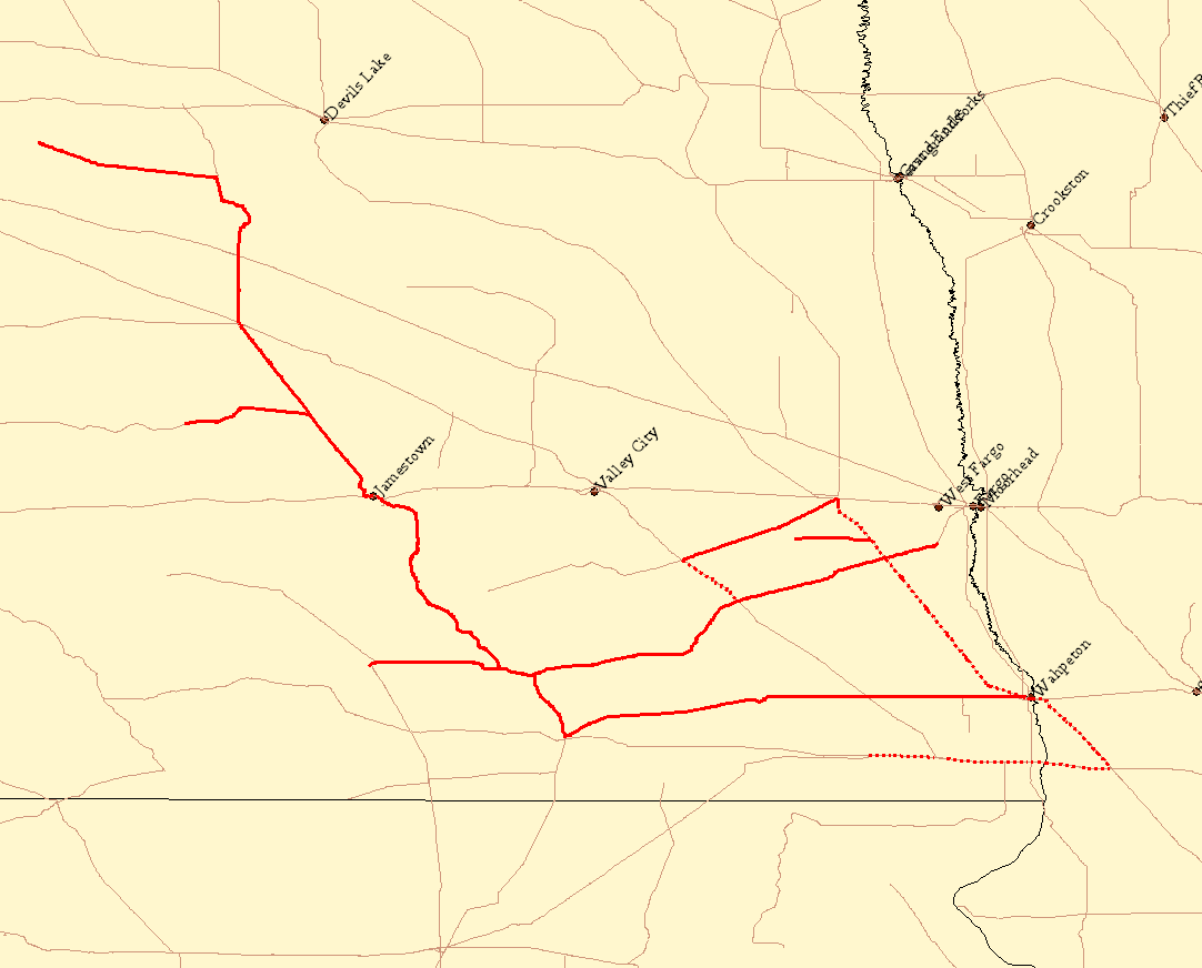
Map of the Red River Valley and Western Railroad system. Solid lines are trackage owned by RRVW; dotted lines are those with trackage rights.
Created with Quantum GIS with data from the National Transportation Atlas Database. Checked against the map from RRVW's official site.
Licensing
 | Permission is granted to copy, distribute and/or modify this document under the terms of the GNU Free Documentation License, Version 1.2 or any later version published by the Free Software Foundation; with no Invariant Sections, no Front-Cover Texts, and no Back-Cover Texts. Subject to disclaimers. |
|
| This work is licensed under the
Creative Commons
Attribution-ShareAlike 3.0 License. This licensing tag was added to this file as part of the GFDL licensing update. |
|
| This file is licensed under the Creative Commons Attribution-ShareAlike license versions 2.5, 2.0, and 1.0. |
 | This file is a candidate to be copied to
Wikimedia Commons.
Any user may perform this transfer; refer to Wikipedia:Moving files to Commons for details. If this file has problems with attribution, copyright, or is otherwise ineligible for Commons, then remove this tag and DO NOT transfer it; repeat violators may be blocked from editing. Other Instructions
| ||
| |||
File history
Click on a date/time to view the file as it appeared at that time.
| Date/Time | Thumbnail | Dimensions | User | Comment | |
|---|---|---|---|---|---|
| current | 03:43, 3 September 2006 |
| 1,082 × 872 (46 KB) | Elkman ( talk | contribs) | Map of the Red River Valley and Western Railroad system. Solid lines are trackage owned by RRVW; dotted lines are those with trackage rights. Created with Quantum GIS with data from [http://www.bts.gov/publications/national_transportation_atlas_data |
You cannot overwrite this file.
File usage
Original file (1,082 × 872 pixels, file size: 46 KB, MIME type: image/png)
Summary
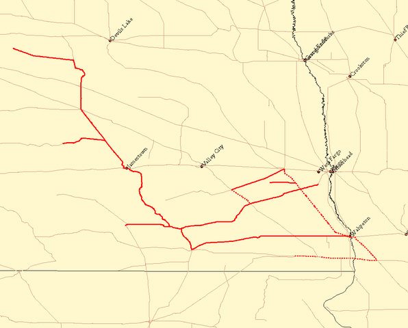
Map of the Red River Valley and Western Railroad system. Solid lines are trackage owned by RRVW; dotted lines are those with trackage rights.
Created with Quantum GIS with data from the National Transportation Atlas Database. Checked against the map from RRVW's official site.
Licensing
|
| Permission is granted to copy, distribute and/or modify this document under the terms of the GNU Free Documentation License, Version 1.2 or any later version published by the Free Software Foundation; with no Invariant Sections, no Front-Cover Texts, and no Back-Cover Texts. Subject to disclaimers. |
|
| This work is licensed under the
Creative Commons
Attribution-ShareAlike 3.0 License. This licensing tag was added to this file as part of the GFDL licensing update. |
|
| This file is licensed under the Creative Commons Attribution-ShareAlike license versions 2.5, 2.0, and 1.0. |
|
| This file is a candidate to be copied to
Wikimedia Commons.
Any user may perform this transfer; refer to Wikipedia:Moving files to Commons for details. If this file has problems with attribution, copyright, or is otherwise ineligible for Commons, then remove this tag and DO NOT transfer it; repeat violators may be blocked from editing. Other Instructions
| ||
| |||
File history
Click on a date/time to view the file as it appeared at that time.
| Date/Time | Thumbnail | Dimensions | User | Comment | |
|---|---|---|---|---|---|
| current | 03:43, 3 September 2006 |
| 1,082 × 872 (46 KB) | Elkman ( talk | contribs) | Map of the Red River Valley and Western Railroad system. Solid lines are trackage owned by RRVW; dotted lines are those with trackage rights. Created with Quantum GIS with data from [http://www.bts.gov/publications/national_transportation_atlas_data |
You cannot overwrite this file.