
Size of this PNG preview of this SVG file:
704 × 599 pixels. Other resolutions:
282 × 240 pixels |
564 × 480 pixels |
902 × 768 pixels |
1,203 × 1,024 pixels |
2,405 × 2,048 pixels |
1,400 × 1,192 pixels.
Original file (SVG file, nominally 1,400 × 1,192 pixels, file size: 205 KB)
| This is a file from the
Wikimedia Commons. Information from its
description page there is shown below. Commons is a freely licensed media file repository. You can help. |
Summary
| Description |
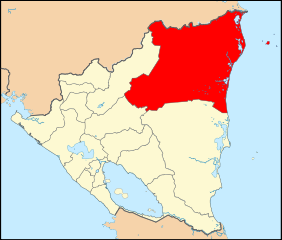
English: Map of Nicaragua highlighting the North Caribbean Coast Autonomous Region
Español: Mapa de Nicaragua mostrando a la Región Autónoma de la Costa Caribe Norte |
| Date | |
| Source | Own work |
| Author | Vrysxy |
Licensing
I, the copyright holder of this work, hereby publish it under the following licenses:
This file is licensed under the
Creative Commons
Attribution-Share Alike 3.0 Unported license.
- You are free:
- to share – to copy, distribute and transmit the work
- to remix – to adapt the work
- Under the following conditions:
- attribution – You must give appropriate credit, provide a link to the license, and indicate if changes were made. You may do so in any reasonable manner, but not in any way that suggests the licensor endorses you or your use.
- share alike – If you remix, transform, or build upon the material, you must distribute your contributions under the same or compatible license as the original.

|
Permission is granted to copy, distribute and/or modify this document under the terms of the GNU Free Documentation License, Version 1.2 or any later version published by the Free Software Foundation; with no Invariant Sections, no Front-Cover Texts, and no Back-Cover Texts. A copy of the license is included in the section entitled GNU Free Documentation License. |
You may select the license of your choice.
File history
Click on a date/time to view the file as it appeared at that time.
| Date/Time | Thumbnail | Dimensions | User | Comment | |
|---|---|---|---|---|---|
| current | 16:26, 17 October 2010 |
| 1,400 × 1,192 (205 KB) | Vrysxy | Wrong map |
| 15:46, 17 October 2010 |
 | 1,400 × 1,192 (205 KB) | Vrysxy | Mejorando borde | |
| 15:44, 17 October 2010 |
 | 1,400 × 1,192 (206 KB) | Vrysxy | mejorando borde | |
| 15:37, 17 October 2010 |
 | 1,400 × 1,192 (206 KB) | Vrysxy | Agregando borde | |
| 03:48, 17 October 2010 |
 | 1,400 × 1,192 (204 KB) | Vrysxy | {{Information |Description={{en|1=Map of Nicaragua highlighting the Region Autonoma del Atlantico Norte }} {{es|1=Mapa de Nicaragua mostrando al departamento de Región Autónoma del Atlántico Norte}} |Source={{own}} |Author= Vrysxy |Date= |
File usage
The following pages on the English Wikipedia use this file (pages on other projects are not listed):
Global file usage
The following other wikis use this file:
- Usage on ar.wikipedia.org
- Usage on be.wikipedia.org
- Usage on ca.wikipedia.org
- Usage on de.wikipedia.org
- Usage on eu.wikipedia.org
- Usage on fa.wikipedia.org
- Usage on fi.wikipedia.org
- Usage on fr.wikipedia.org
- Usage on id.wikipedia.org
- Usage on ko.wikipedia.org
- Usage on la.wikipedia.org
- Usage on mk.wikipedia.org
- Usage on nds.wikipedia.org
- Usage on pt.wikipedia.org
- Usage on qu.wikipedia.org
- Usage on ru.wikipedia.org
- Usage on sco.wikipedia.org
- Usage on sr.wikipedia.org
- Usage on sv.wikipedia.org
- Usage on tr.wikipedia.org
- Usage on uk.wikipedia.org
- Usage on war.wikipedia.org
- Usage on xmf.wikipedia.org
- Usage on zh.wikipedia.org
Size of this PNG preview of this SVG file:
704 × 599 pixels. Other resolutions:
282 × 240 pixels |
564 × 480 pixels |
902 × 768 pixels |
1,203 × 1,024 pixels |
2,405 × 2,048 pixels |
1,400 × 1,192 pixels.
Original file (SVG file, nominally 1,400 × 1,192 pixels, file size: 205 KB)
| This is a file from the
Wikimedia Commons. Information from its
description page there is shown below. Commons is a freely licensed media file repository. You can help. |
Summary
| Description |
English: Map of Nicaragua highlighting the North Caribbean Coast Autonomous Region
Español: Mapa de Nicaragua mostrando a la Región Autónoma de la Costa Caribe Norte |
| Date | |
| Source | Own work |
| Author | Vrysxy |
Licensing
I, the copyright holder of this work, hereby publish it under the following licenses:
This file is licensed under the
Creative Commons
Attribution-Share Alike 3.0 Unported license.
- You are free:
- to share – to copy, distribute and transmit the work
- to remix – to adapt the work
- Under the following conditions:
- attribution – You must give appropriate credit, provide a link to the license, and indicate if changes were made. You may do so in any reasonable manner, but not in any way that suggests the licensor endorses you or your use.
- share alike – If you remix, transform, or build upon the material, you must distribute your contributions under the same or compatible license as the original.
|
|
Permission is granted to copy, distribute and/or modify this document under the terms of the GNU Free Documentation License, Version 1.2 or any later version published by the Free Software Foundation; with no Invariant Sections, no Front-Cover Texts, and no Back-Cover Texts. A copy of the license is included in the section entitled GNU Free Documentation License. |
You may select the license of your choice.
File history
Click on a date/time to view the file as it appeared at that time.
| Date/Time | Thumbnail | Dimensions | User | Comment | |
|---|---|---|---|---|---|
| current | 16:26, 17 October 2010 |
| 1,400 × 1,192 (205 KB) | Vrysxy | Wrong map |
| 15:46, 17 October 2010 |
| 1,400 × 1,192 (205 KB) | Vrysxy | Mejorando borde | |
| 15:44, 17 October 2010 |
| 1,400 × 1,192 (206 KB) | Vrysxy | mejorando borde | |
| 15:37, 17 October 2010 |
| 1,400 × 1,192 (206 KB) | Vrysxy | Agregando borde | |
| 03:48, 17 October 2010 |
| 1,400 × 1,192 (204 KB) | Vrysxy | {{Information |Description={{en|1=Map of Nicaragua highlighting the Region Autonoma del Atlantico Norte }} {{es|1=Mapa de Nicaragua mostrando al departamento de Región Autónoma del Atlántico Norte}} |Source={{own}} |Author= Vrysxy |Date= |
File usage
The following pages on the English Wikipedia use this file (pages on other projects are not listed):
Global file usage
The following other wikis use this file:
- Usage on ar.wikipedia.org
- Usage on be.wikipedia.org
- Usage on ca.wikipedia.org
- Usage on de.wikipedia.org
- Usage on eu.wikipedia.org
- Usage on fa.wikipedia.org
- Usage on fi.wikipedia.org
- Usage on fr.wikipedia.org
- Usage on id.wikipedia.org
- Usage on ko.wikipedia.org
- Usage on la.wikipedia.org
- Usage on mk.wikipedia.org
- Usage on nds.wikipedia.org
- Usage on pt.wikipedia.org
- Usage on qu.wikipedia.org
- Usage on ru.wikipedia.org
- Usage on sco.wikipedia.org
- Usage on sr.wikipedia.org
- Usage on sv.wikipedia.org
- Usage on tr.wikipedia.org
- Usage on uk.wikipedia.org
- Usage on war.wikipedia.org
- Usage on xmf.wikipedia.org
- Usage on zh.wikipedia.org