
Size of this preview:
490 × 599 pixels. Other resolutions:
196 × 240 pixels |
392 × 480 pixels |
628 × 768 pixels |
837 × 1,024 pixels |
1,675 × 2,048 pixels |
3,154 × 3,857 pixels.
Original file (3,154 × 3,857 pixels, file size: 2.71 MB, MIME type: image/png)
| This is a file from the
Wikimedia Commons. Information from its
description page there is shown below. Commons is a freely licensed media file repository. You can help. |
| Description |
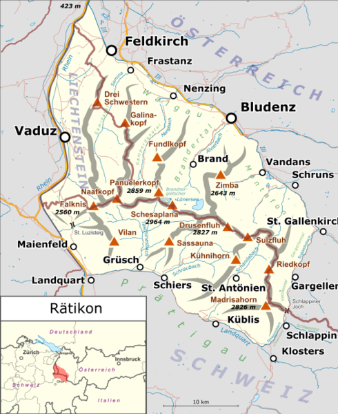
Deutsch: Lagekarte des
Rätikons. |
|||||||||
| Date | ||||||||||
| Source |
Own work Map was created using:
|
|||||||||
| Creator | ||||||||||
| Permission ( Reusing this file) |
Map data (c) OpenStreetMap (and) contributors, CC-BY-SA | |||||||||
| Geotemporal data | ||||||||||
| Bounding box |
|
|||||||||
| Georeferencing | ||||||||||
This file is licensed under the
Creative Commons
Attribution-Share Alike 2.0 Generic license.
- You are free:
- to share – to copy, distribute and transmit the work
- to remix – to adapt the work
- Under the following conditions:
- attribution – You must give appropriate credit, provide a link to the license, and indicate if changes were made. You may do so in any reasonable manner, but not in any way that suggests the licensor endorses you or your use.
- share alike – If you remix, transform, or build upon the material, you must distribute your contributions under the same or compatible license as the original.
File history
Click on a date/time to view the file as it appeared at that time.
| Date/Time | Thumbnail | Dimensions | User | Comment | |
|---|---|---|---|---|---|
| current | 16:07, 23 October 2017 |
| 3,154 × 3,857 (2.71 MB) | Pechristener | neutralere Locationmap |
| 23:39, 18 March 2015 |
 | 3,364 × 4,114 (2.99 MB) | Pechristener | St. Gallenkirch hinzu / Panüeler hinzu / einige Höhenangaben hinzu | |
| 19:07, 17 March 2015 |
 | 3,364 × 4,114 (2.93 MB) | Pechristener | {{Information |Description={{de|1=Lagekarte des de:Rätikon}} |Source ={{own}} Map was created using: *[http://www.openstreetmap.org/ Open Street Map] * Switzerland location map.svg for location ma... |
File usage
The following pages on the English Wikipedia use this file (pages on other projects are not listed):
Global file usage
The following other wikis use this file:
- Usage on als.wikipedia.org
- Usage on de.wikipedia.org
- Zimba
- Rätikon
- Schesaplana
- Panüeler Kopf
- Sulzfluh
- Totalphütte
- Alvier (Fluss)
- Scheienfluh
- Carschinahütte
- Liste der Gebirgsgruppen in den Ostalpen (nach AVE)
- Benutzer Diskussion:Pechristener/Archiv/1
- Gänglesee
- Vorlage:Positionskarte Rätikon
- Wikipedia:Kartenwerkstatt/Archiv/Zurückgewiesene und zurückgestellte Aufträge 2016
- Partnunsee
- Valser Bach (Taschinasbach)
- Girenspitz (Schuders)
- Usage on de.wikivoyage.org
- Usage on it.wikipedia.org
- Usage on it.wikivoyage.org
- Usage on no.wikipedia.org
- Usage on ru.wikipedia.org
- Usage on sv.wikipedia.org
- Usage on uk.wikipedia.org
- Usage on www.wikidata.org
Metadata
Size of this preview:
490 × 599 pixels. Other resolutions:
196 × 240 pixels |
392 × 480 pixels |
628 × 768 pixels |
837 × 1,024 pixels |
1,675 × 2,048 pixels |
3,154 × 3,857 pixels.
Original file (3,154 × 3,857 pixels, file size: 2.71 MB, MIME type: image/png)
| This is a file from the
Wikimedia Commons. Information from its
description page there is shown below. Commons is a freely licensed media file repository. You can help. |
| Description |
Deutsch: Lagekarte des
Rätikons. |
|||||||||
| Date | ||||||||||
| Source |
Own work Map was created using:
|
|||||||||
| Creator | ||||||||||
| Permission ( Reusing this file) |
Map data (c) OpenStreetMap (and) contributors, CC-BY-SA | |||||||||
| Geotemporal data | ||||||||||
| Bounding box |
|
|||||||||
| Georeferencing | ||||||||||
This file is licensed under the
Creative Commons
Attribution-Share Alike 2.0 Generic license.
- You are free:
- to share – to copy, distribute and transmit the work
- to remix – to adapt the work
- Under the following conditions:
- attribution – You must give appropriate credit, provide a link to the license, and indicate if changes were made. You may do so in any reasonable manner, but not in any way that suggests the licensor endorses you or your use.
- share alike – If you remix, transform, or build upon the material, you must distribute your contributions under the same or compatible license as the original.
File history
Click on a date/time to view the file as it appeared at that time.
| Date/Time | Thumbnail | Dimensions | User | Comment | |
|---|---|---|---|---|---|
| current | 16:07, 23 October 2017 |
| 3,154 × 3,857 (2.71 MB) | Pechristener | neutralere Locationmap |
| 23:39, 18 March 2015 |
| 3,364 × 4,114 (2.99 MB) | Pechristener | St. Gallenkirch hinzu / Panüeler hinzu / einige Höhenangaben hinzu | |
| 19:07, 17 March 2015 |
| 3,364 × 4,114 (2.93 MB) | Pechristener | {{Information |Description={{de|1=Lagekarte des de:Rätikon}} |Source ={{own}} Map was created using: *[http://www.openstreetmap.org/ Open Street Map] * Switzerland location map.svg for location ma... |
File usage
The following pages on the English Wikipedia use this file (pages on other projects are not listed):
Global file usage
The following other wikis use this file:
- Usage on als.wikipedia.org
- Usage on de.wikipedia.org
- Zimba
- Rätikon
- Schesaplana
- Panüeler Kopf
- Sulzfluh
- Totalphütte
- Alvier (Fluss)
- Scheienfluh
- Carschinahütte
- Liste der Gebirgsgruppen in den Ostalpen (nach AVE)
- Benutzer Diskussion:Pechristener/Archiv/1
- Gänglesee
- Vorlage:Positionskarte Rätikon
- Wikipedia:Kartenwerkstatt/Archiv/Zurückgewiesene und zurückgestellte Aufträge 2016
- Partnunsee
- Valser Bach (Taschinasbach)
- Girenspitz (Schuders)
- Usage on de.wikivoyage.org
- Usage on it.wikipedia.org
- Usage on it.wikivoyage.org
- Usage on no.wikipedia.org
- Usage on ru.wikipedia.org
- Usage on sv.wikipedia.org
- Usage on uk.wikipedia.org
- Usage on www.wikidata.org