Original file (948 × 770 pixels, file size: 28 KB, MIME type: image/png)
| This is a file from the
Wikimedia Commons. Information from its
description page there is shown below. Commons is a freely licensed media file repository. You can help. |
Summary
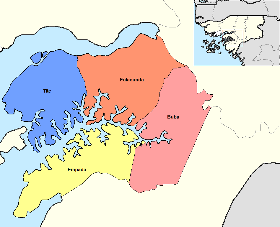
Map of the sectors of Quinara region of Guinea-Bissau. Created by Rarelibra 14:49, 14 September 2006 (UTC) for public domain use, using MapInfo Professional v9.5 and various mapping resources.
Licensing
| This work has been released into the
public domain by its author,
Rarelibra at
English Wikipedia. This applies worldwide. In some countries this may not be legally possible; if so: Rarelibra grants anyone the right to use this work for any purpose, without any conditions, unless such conditions are required by law. |
File history
Click on a date/time to view the file as it appeared at that time.
| Date/Time | Thumbnail | Dimensions | User | Comment | |
|---|---|---|---|---|---|
| current | 09:36, 19 August 2015 |
| 948 × 770 (28 KB) | Naturals | colors |
| 10:33, 5 January 2008 |
 | 1,056 × 816 (33 KB) | Francofranco56 | == Summary == Map of the sectors of Quinara region of Guinea-Bissau. Created by Rarelibra 14:49, 14 September 2006 (UTC) for public domain use, using MapInfo Professional v9.5 and various mapping resources. == Licensing == {{PD-self}} |
File usage
Global file usage
The following other wikis use this file:
- Usage on ca.wikipedia.org
- Usage on cs.wikipedia.org
- Usage on de.wikipedia.org
- Usage on es.wikipedia.org
- Usage on fi.wikipedia.org
- Usage on frr.wikipedia.org
- Usage on fr.wikipedia.org
- Usage on it.wikipedia.org
- Usage on ja.wikipedia.org
- Usage on ko.wikipedia.org
- Usage on lb.wikipedia.org
- Usage on lt.wikipedia.org
- Usage on nl.wikipedia.org
- Usage on pt.wikipedia.org
- Usage on ro.wikipedia.org
- Usage on ru.wikipedia.org
- Usage on sv.wikipedia.org
- Usage on tr.wikipedia.org
- Usage on zh.wikipedia.org
Metadata
Original file (948 × 770 pixels, file size: 28 KB, MIME type: image/png)
| This is a file from the
Wikimedia Commons. Information from its
description page there is shown below. Commons is a freely licensed media file repository. You can help. |
Summary
Map of the sectors of Quinara region of Guinea-Bissau. Created by Rarelibra 14:49, 14 September 2006 (UTC) for public domain use, using MapInfo Professional v9.5 and various mapping resources.
Licensing
| This work has been released into the
public domain by its author,
Rarelibra at
English Wikipedia. This applies worldwide. In some countries this may not be legally possible; if so: Rarelibra grants anyone the right to use this work for any purpose, without any conditions, unless such conditions are required by law. |
File history
Click on a date/time to view the file as it appeared at that time.
| Date/Time | Thumbnail | Dimensions | User | Comment | |
|---|---|---|---|---|---|
| current | 09:36, 19 August 2015 |
| 948 × 770 (28 KB) | Naturals | colors |
| 10:33, 5 January 2008 |
| 1,056 × 816 (33 KB) | Francofranco56 | == Summary == Map of the sectors of Quinara region of Guinea-Bissau. Created by Rarelibra 14:49, 14 September 2006 (UTC) for public domain use, using MapInfo Professional v9.5 and various mapping resources. == Licensing == {{PD-self}} |
File usage
Global file usage
The following other wikis use this file:
- Usage on ca.wikipedia.org
- Usage on cs.wikipedia.org
- Usage on de.wikipedia.org
- Usage on es.wikipedia.org
- Usage on fi.wikipedia.org
- Usage on frr.wikipedia.org
- Usage on fr.wikipedia.org
- Usage on it.wikipedia.org
- Usage on ja.wikipedia.org
- Usage on ko.wikipedia.org
- Usage on lb.wikipedia.org
- Usage on lt.wikipedia.org
- Usage on nl.wikipedia.org
- Usage on pt.wikipedia.org
- Usage on ro.wikipedia.org
- Usage on ru.wikipedia.org
- Usage on sv.wikipedia.org
- Usage on tr.wikipedia.org
- Usage on zh.wikipedia.org