
Original file (SVG file, nominally 414 × 491 pixels, file size: 649 KB)
| This is a file from the
Wikimedia Commons. Information from its
description page there is shown below. Commons is a freely licensed media file repository. You can help. |
Summary
| Description |
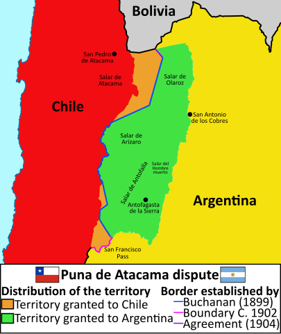
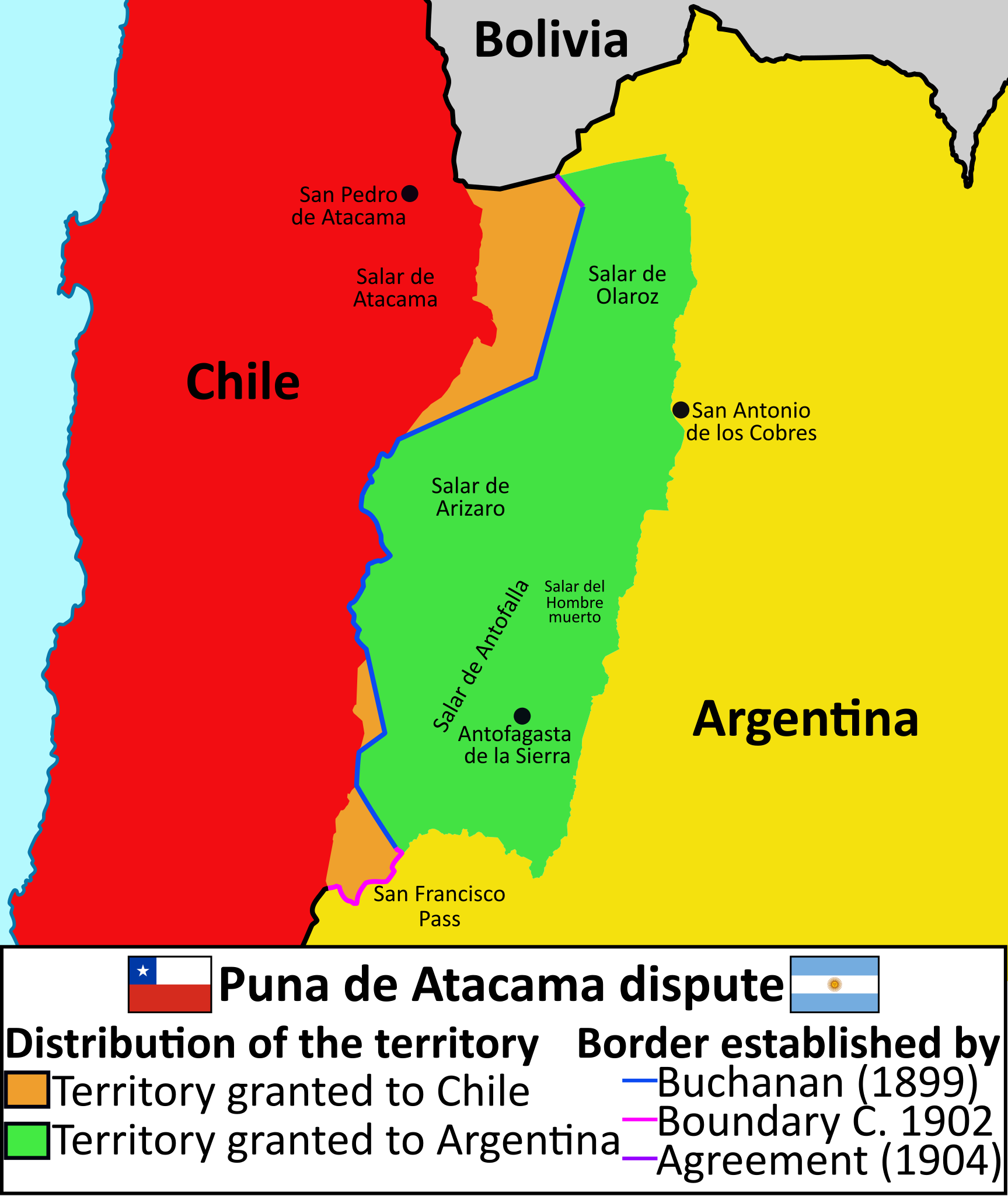
English: Map of the Puna de Atacama dispute |
||||||||||||
| Date | |||||||||||||
| Source |
Own work Coastline extracted from: File:Chile location map.svg by NordNordWest |
||||||||||||
| Author |
Janitoalevic Coastline extracted from: File:Chile location map.svg by NordNordWest |
||||||||||||
| Other versions |
|
||||||||||||
| SVG development | |||||||||||||


![[1]](https://i.imgur.com/JMRdbz1.png)
![[2]](https://i.imgur.com/R1CQHHa.jpg)
![[3]](https://i.imgur.com/E7RATQL.jpg)
![[4]](https://i.imgur.com/aU437nT.jpg)
![[5]](https://i.imgur.com/W4vmZQu.jpg)
![[6]](https://i.imgur.com/hVycqFX.jpg)
![[7]](https://i.imgur.com/JLxDv86.jpg)
![[8]](https://i.imgur.com/y8LsBtF.png)
![[10]](https://commons.wikimedia.org/wiki/File:Puna_de_Atacama_Mapa_1892_(recorte).jpg)
Licensing
- You are free:
- to share – to copy, distribute and transmit the work
- to remix – to adapt the work
- Under the following conditions:
- attribution – You must give appropriate credit, provide a link to the license, and indicate if changes were made. You may do so in any reasonable manner, but not in any way that suggests the licensor endorses you or your use.
- share alike – If you remix, transform, or build upon the material, you must distribute your contributions under the same or compatible license as the original.
File history
Click on a date/time to view the file as it appeared at that time.
| Date/Time | Thumbnail | Dimensions | User | Comment | |
|---|---|---|---|---|---|
| current | 23:09, 25 September 2023 |
| 414 × 491 (649 KB) | Janitoalevic | . |
| 18:35, 20 May 2019 |
 | 414 × 491 (651 KB) | Janitoalevic | text | |
| 18:34, 20 May 2019 |
 | 414 × 491 (167 KB) | Janitoalevic | User created page with UploadWizard |
File usage
Global file usage
The following other wikis use this file:
- Usage on de.wikipedia.org
- Usage on fr.wikipedia.org
- Usage on mk.wikipedia.org
- Usage on sl.wikipedia.org
- Usage on ta.wikipedia.org
Metadata
Original file (SVG file, nominally 414 × 491 pixels, file size: 649 KB)
| This is a file from the
Wikimedia Commons. Information from its
description page there is shown below. Commons is a freely licensed media file repository. You can help. |
Summary
| Description |
English: Map of the Puna de Atacama dispute |
||||||||||||
| Date | |||||||||||||
| Source |
Own work Coastline extracted from: File:Chile location map.svg by NordNordWest |
||||||||||||
| Author |
Janitoalevic Coastline extracted from: File:Chile location map.svg by NordNordWest |
||||||||||||
| Other versions |
|
||||||||||||
| SVG development | |||||||||||||
Licensing
- You are free:
- to share – to copy, distribute and transmit the work
- to remix – to adapt the work
- Under the following conditions:
- attribution – You must give appropriate credit, provide a link to the license, and indicate if changes were made. You may do so in any reasonable manner, but not in any way that suggests the licensor endorses you or your use.
- share alike – If you remix, transform, or build upon the material, you must distribute your contributions under the same or compatible license as the original.
File history
Click on a date/time to view the file as it appeared at that time.
| Date/Time | Thumbnail | Dimensions | User | Comment | |
|---|---|---|---|---|---|
| current | 23:09, 25 September 2023 |
| 414 × 491 (649 KB) | Janitoalevic | . |
| 18:35, 20 May 2019 |
| 414 × 491 (651 KB) | Janitoalevic | text | |
| 18:34, 20 May 2019 |
| 414 × 491 (167 KB) | Janitoalevic | User created page with UploadWizard |
File usage
Global file usage
The following other wikis use this file:
- Usage on de.wikipedia.org
- Usage on fr.wikipedia.org
- Usage on mk.wikipedia.org
- Usage on sl.wikipedia.org
- Usage on ta.wikipedia.org