
Original file (7,440 × 5,487 pixels, file size: 5.32 MB, MIME type: image/jpeg)
| This is a file from the
Wikimedia Commons. Information from its
description page there is shown below. Commons is a freely licensed media file repository. You can help. |
Summary
| Description |
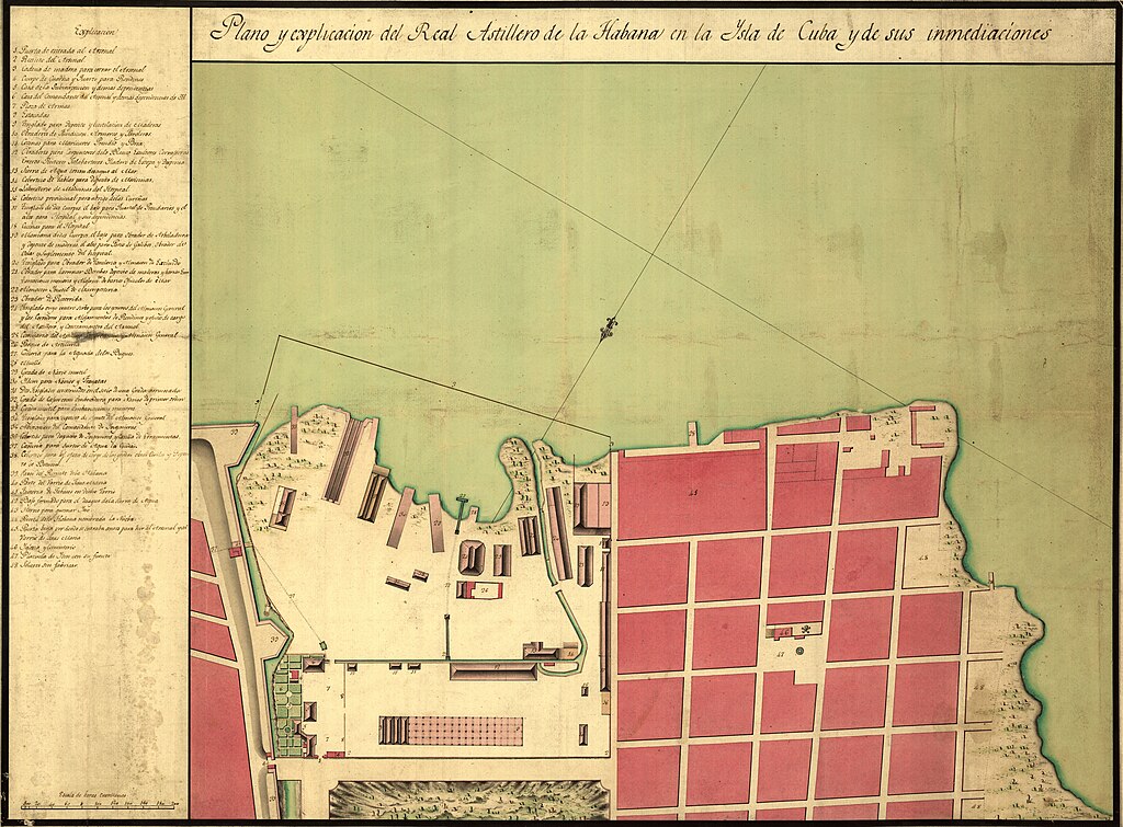
English: Oriented with north toward the lower left. Watermark: C. & I. Honig. Pen-and-ink and watercolor. Mounted on cloth backing. LC Luso-Hispanic World, 354 Indexed. Maggs number annotated in pencil in lower right margin: 106. Annotated in blue ink on sticker on verso: 6883-11. Available also through the Library of Congress Web site as a raster image. Latin American Atlantic port cities exhibit #11 Vault |
||
| Title | Plano y explicación del Real Astillero de la Habana en la ysla de Cuba y de sus inmediaciones. | ||
| Shelf ID | G4924.H3P55 17-- .P5 | ||
| Date | |||
| Source | https://www.loc.gov/item/91680731/ | ||
| Author | Unknown author | ||
| Permission ( Reusing this file) |
|
||
| Other versions |
|
||
| Location | Havana · Cuba | ||
| Part of | American Memory · Cities And Towns · Catalog · Geography And Map Division | ||
| Subject | Maps, Manuscript · Havana · Cuba · Havana (Cuba) · Maps · Early Works To 1800 · Manuscript Maps · Harbors |

Licensing
|
This is a faithful photographic reproduction of a two-dimensional,
public domain work of art. The work of art itself is in the public domain for the following reason:
The official position taken by the Wikimedia Foundation is that "faithful reproductions of two-dimensional public domain works of art are public domain".
This photographic reproduction is therefore also considered to be in the public domain in the United States. In other jurisdictions, re-use of this content may be restricted; see Reuse of PD-Art photographs for details. | ||||
File history
Click on a date/time to view the file as it appeared at that time.
| Date/Time | Thumbnail | Dimensions | User | Comment | |
|---|---|---|---|---|---|
| current | 17:15, 25 April 2024 |
| 7,440 × 5,487 (5.32 MB) | User-duck | Cropped annotation using CropTool with lossless mode. |
| 11:50, 31 May 2018 |
 | 7,520 × 5,650 (5.6 MB) | Fæ | LOC Maps https://www.loc.gov/item/91680731/ #16173 |
File usage
Global file usage
The following other wikis use this file:
- Usage on es.wikipedia.org
- Usage on www.wikidata.org
Original file (7,440 × 5,487 pixels, file size: 5.32 MB, MIME type: image/jpeg)
| This is a file from the
Wikimedia Commons. Information from its
description page there is shown below. Commons is a freely licensed media file repository. You can help. |
Summary
| Description |
English: Oriented with north toward the lower left. Watermark: C. & I. Honig. Pen-and-ink and watercolor. Mounted on cloth backing. LC Luso-Hispanic World, 354 Indexed. Maggs number annotated in pencil in lower right margin: 106. Annotated in blue ink on sticker on verso: 6883-11. Available also through the Library of Congress Web site as a raster image. Latin American Atlantic port cities exhibit #11 Vault |
||
| Title | Plano y explicación del Real Astillero de la Habana en la ysla de Cuba y de sus inmediaciones. | ||
| Shelf ID | G4924.H3P55 17-- .P5 | ||
| Date | |||
| Source | https://www.loc.gov/item/91680731/ | ||
| Author | Unknown author | ||
| Permission ( Reusing this file) |
|
||
| Other versions |
|
||
| Location | Havana · Cuba | ||
| Part of | American Memory · Cities And Towns · Catalog · Geography And Map Division | ||
| Subject | Maps, Manuscript · Havana · Cuba · Havana (Cuba) · Maps · Early Works To 1800 · Manuscript Maps · Harbors |
Licensing
|
This is a faithful photographic reproduction of a two-dimensional,
public domain work of art. The work of art itself is in the public domain for the following reason:
The official position taken by the Wikimedia Foundation is that "faithful reproductions of two-dimensional public domain works of art are public domain".
This photographic reproduction is therefore also considered to be in the public domain in the United States. In other jurisdictions, re-use of this content may be restricted; see Reuse of PD-Art photographs for details. | ||||
File history
Click on a date/time to view the file as it appeared at that time.
| Date/Time | Thumbnail | Dimensions | User | Comment | |
|---|---|---|---|---|---|
| current | 17:15, 25 April 2024 |
| 7,440 × 5,487 (5.32 MB) | User-duck | Cropped annotation using CropTool with lossless mode. |
| 11:50, 31 May 2018 |
| 7,520 × 5,650 (5.6 MB) | Fæ | LOC Maps https://www.loc.gov/item/91680731/ #16173 |
File usage
Global file usage
The following other wikis use this file:
- Usage on es.wikipedia.org
- Usage on www.wikidata.org