Photos • Location


Size of this preview:
739 × 599 pixels. Other resolutions:
296 × 240 pixels |
592 × 480 pixels |
947 × 768 pixels |
1,262 × 1,024 pixels |
1,605 × 1,302 pixels.
Original file (1,605 × 1,302 pixels, file size: 458 KB, MIME type: image/jpeg)
| This is a file from the
Wikimedia Commons. Information from its
description page there is shown below. Commons is a freely licensed media file repository. You can help. |
Summary
| Description |
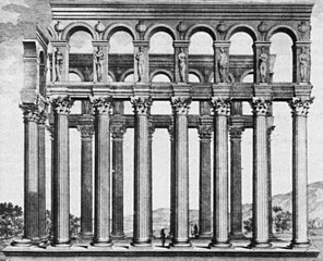
Français : Edifice gallo-romain du IIIe siècle piliers de tutelle à Bordeaux détruit en 1675. Dessin et plan de Claude Perrault (1613-1688) à l'occasion d'un voyage à Bordeaux en 1669, gravé par Pierre Lepautre vers 1684.
English: Gallo-roman building of the IIIrd century named piliers de tutelle in Bordeaux (France). Destroyed in 1675. Drawing and map by Claude Perrault (1613-1688), engraved by Pierre Lepautre. |
||||||||||||||||||||||||||||||||||||||||||||||||
| Date | |||||||||||||||||||||||||||||||||||||||||||||||||
| Source | Claude Perrault, Les dix livres d'architecture de Vitruve, 2ème édition 1684. | ||||||||||||||||||||||||||||||||||||||||||||||||
| Author |
Designer :
|
||||||||||||||||||||||||||||||||||||||||||||||||
| Other versions | |||||||||||||||||||||||||||||||||||||||||||||||||

.JPG)
_(cropped).JPG)
| Object location |
| View this and other nearby images on: OpenStreetMap |
|
|---|
_(cropped).JPG¶ms=044.842854_N_-000.574443_E_globe:Earth_class:object_type:object_region:FR_&language=en)
Licensing
|
This is a faithful photographic reproduction of a two-dimensional,
public domain work of art. The work of art itself is in the public domain for the following reason:
The official position taken by the Wikimedia Foundation is that "faithful reproductions of two-dimensional public domain works of art are public domain".
This photographic reproduction is therefore also considered to be in the public domain in the United States. In other jurisdictions, re-use of this content may be restricted; see Reuse of PD-Art photographs for details. | ||||
File history
Click on a date/time to view the file as it appeared at that time.
| Date/Time | Thumbnail | Dimensions | User | Comment | |
|---|---|---|---|---|---|
| current | 15:56, 25 May 2020 |
| 1,605 × 1,302 (458 KB) | Gts-tg | File:Piliers de tutelle (Bordeaux 1669).JPG cropped 1 % horizontally, 39 % vertically using CropTool with precise mode. |
.JPG)
File usage
The following pages on the English Wikipedia use this file (pages on other projects are not listed):
Global file usage
The following other wikis use this file:
- Usage on bg.wikipedia.org
- Usage on el.wikipedia.org
- Usage on es.wikipedia.org
- Usage on fr.wikipedia.org
- Usage on ru.wikipedia.org
- Usage on sl.wikipedia.org
_(cropped).JPG)
Size of this preview:
739 × 599 pixels. Other resolutions:
296 × 240 pixels |
592 × 480 pixels |
947 × 768 pixels |
1,262 × 1,024 pixels |
1,605 × 1,302 pixels.
Original file (1,605 × 1,302 pixels, file size: 458 KB, MIME type: image/jpeg)
| This is a file from the
Wikimedia Commons. Information from its
description page there is shown below. Commons is a freely licensed media file repository. You can help. |
Summary
| Description |
Français : Edifice gallo-romain du IIIe siècle piliers de tutelle à Bordeaux détruit en 1675. Dessin et plan de Claude Perrault (1613-1688) à l'occasion d'un voyage à Bordeaux en 1669, gravé par Pierre Lepautre vers 1684.
English: Gallo-roman building of the IIIrd century named piliers de tutelle in Bordeaux (France). Destroyed in 1675. Drawing and map by Claude Perrault (1613-1688), engraved by Pierre Lepautre. |
||||||||||||||||||||||||||||||||||||||||||||||||
| Date | |||||||||||||||||||||||||||||||||||||||||||||||||
| Source | Claude Perrault, Les dix livres d'architecture de Vitruve, 2ème édition 1684. | ||||||||||||||||||||||||||||||||||||||||||||||||
| Author |
Designer :
|
||||||||||||||||||||||||||||||||||||||||||||||||
| Other versions | |||||||||||||||||||||||||||||||||||||||||||||||||
| Object location |
| View this and other nearby images on: OpenStreetMap |
|
|---|
Licensing
|
This is a faithful photographic reproduction of a two-dimensional,
public domain work of art. The work of art itself is in the public domain for the following reason:
The official position taken by the Wikimedia Foundation is that "faithful reproductions of two-dimensional public domain works of art are public domain".
This photographic reproduction is therefore also considered to be in the public domain in the United States. In other jurisdictions, re-use of this content may be restricted; see Reuse of PD-Art photographs for details. | ||||
File history
Click on a date/time to view the file as it appeared at that time.
| Date/Time | Thumbnail | Dimensions | User | Comment | |
|---|---|---|---|---|---|
| current | 15:56, 25 May 2020 |
| 1,605 × 1,302 (458 KB) | Gts-tg | File:Piliers de tutelle (Bordeaux 1669).JPG cropped 1 % horizontally, 39 % vertically using CropTool with precise mode. |
File usage
The following pages on the English Wikipedia use this file (pages on other projects are not listed):
Global file usage
The following other wikis use this file:
- Usage on bg.wikipedia.org
- Usage on el.wikipedia.org
- Usage on es.wikipedia.org
- Usage on fr.wikipedia.org
- Usage on ru.wikipedia.org
- Usage on sl.wikipedia.org