
Original file (10,766 × 18,097 pixels, file size: 25.54 MB, MIME type: image/jpeg)
| This is a file from the
Wikimedia Commons. Information from its
description page there is shown below. Commons is a freely licensed media file repository. You can help. |
Summary
| Warning | The original file is very high-resolution. It might not load properly or could cause your browser to freeze when opened at full size. |
|---|
| Description |
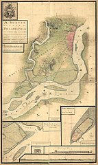
English: A survey of the city of Philadelphia and its environs shewing the several works constructed by His Majesty's troops, under the command of Sir
William Howe, since their possession of that city 26th. September 1777, comprehending likewise the attacks against
Fort Mifflin on Mud Island, and until it's reduction, 16th November 1777. |
||
| Date | |||
| Source | Library of Congress | ||
| Author |
Contributor Names:
|
||
| Other versions |
|


Licensing
|
This work is in the public domain in its country of origin and other countries and areas where the copyright term is the author's life plus 70 years or fewer. This work is in the public domain in the United States because it was published (or registered with the U.S. Copyright Office) before January 1, 1929. | |
| This file has been identified as being free of known restrictions under copyright law, including all related and neighboring rights. | |
File history
Click on a date/time to view the file as it appeared at that time.
| Date/Time | Thumbnail | Dimensions | User | Comment | |
|---|---|---|---|---|---|
| current | 20:15, 12 January 2021 |
| 10,766 × 18,097 (25.54 MB) | Gwillhickers | Uploaded a work by Contributor Names Nicole, Pierre, -1784. Montrésor, John, 1736-1799. Created / Published 1777 from [https://www.loc.gov/item/gm71000933/ '''Library of Congress'''] with UploadWizard |
File usage
Global file usage
The following other wikis use this file:
- Usage on nl.wikipedia.org
Metadata
Original file (10,766 × 18,097 pixels, file size: 25.54 MB, MIME type: image/jpeg)
| This is a file from the
Wikimedia Commons. Information from its
description page there is shown below. Commons is a freely licensed media file repository. You can help. |
Summary
| Warning | The original file is very high-resolution. It might not load properly or could cause your browser to freeze when opened at full size. |
|---|
| Description |
English: A survey of the city of Philadelphia and its environs shewing the several works constructed by His Majesty's troops, under the command of Sir
William Howe, since their possession of that city 26th. September 1777, comprehending likewise the attacks against
Fort Mifflin on Mud Island, and until it's reduction, 16th November 1777. |
||
| Date | |||
| Source | Library of Congress | ||
| Author |
Contributor Names:
|
||
| Other versions |
|
Licensing
|
This work is in the public domain in its country of origin and other countries and areas where the copyright term is the author's life plus 70 years or fewer. This work is in the public domain in the United States because it was published (or registered with the U.S. Copyright Office) before January 1, 1929. | |
| This file has been identified as being free of known restrictions under copyright law, including all related and neighboring rights. | |
File history
Click on a date/time to view the file as it appeared at that time.
| Date/Time | Thumbnail | Dimensions | User | Comment | |
|---|---|---|---|---|---|
| current | 20:15, 12 January 2021 |
| 10,766 × 18,097 (25.54 MB) | Gwillhickers | Uploaded a work by Contributor Names Nicole, Pierre, -1784. Montrésor, John, 1736-1799. Created / Published 1777 from [https://www.loc.gov/item/gm71000933/ '''Library of Congress'''] with UploadWizard |
File usage
Global file usage
The following other wikis use this file:
- Usage on nl.wikipedia.org