
Size of this preview:
684 × 599 pixels. Other resolutions:
274 × 240 pixels |
548 × 480 pixels |
979 × 858 pixels.
Original file (979 × 858 pixels, file size: 47 KB, MIME type: image/gif)
| This is a file from the
Wikimedia Commons. Information from its
description page there is shown below. Commons is a freely licensed media file repository. You can help. |
Summary
| Description |
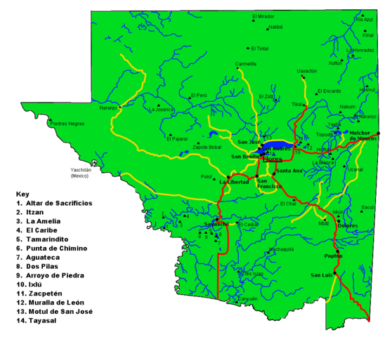
English: Map of the
Maya archaeological sites in
El Petén Department.
Español: Mapa del departamento guatemalteco de
Petén, con los más importantes
sitios arqueológicos Mayas. |
| Date | |
| Source | Own work |
| Author | Simon Burchell |
Licensing
I, the copyright holder of this work, hereby publish it under the following license:
This file is licensed under the
Creative Commons
Attribution-Share Alike 3.0 Unported license.
- You are free:
- to share – to copy, distribute and transmit the work
- to remix – to adapt the work
- Under the following conditions:
- attribution – You must give appropriate credit, provide a link to the license, and indicate if changes were made. You may do so in any reasonable manner, but not in any way that suggests the licensor endorses you or your use.
- share alike – If you remix, transform, or build upon the material, you must distribute your contributions under the same or compatible license as the original.
File history
Click on a date/time to view the file as it appeared at that time.
| Date/Time | Thumbnail | Dimensions | User | Comment | |
|---|---|---|---|---|---|
| current | 12:38, 19 November 2010 |
| 979 × 858 (47 KB) | Simon Burchell | Remove stray ruins symbols that crept in during last edit. |
| 12:31, 19 November 2010 |
 | 979 × 858 (47 KB) | Simon Burchell | Added some more archaeological sites. | |
| 11:14, 19 November 2010 |
 | 979 × 858 (46 KB) | Simon Burchell | Correct location of La Blanca, added location of Ucanal and moved Holtun text. | |
| 11:19, 18 November 2010 |
 | 979 × 858 (46 KB) | Simon Burchell | {{Information |Description={{en|1=Map of the Peten department of Guatemala with important Maya archaeological sites marked.}} {{es|1=Mapa del departamento guatemalteco de Petén, con los más importantes sitios arqueológicos mayas.}} |Source={{own}} |Aut |
File usage
The following pages on the English Wikipedia use this file (pages on other projects are not listed):
Global file usage
The following other wikis use this file:
- Usage on bn.wikipedia.org
- Usage on ca.wikipedia.org
- Usage on de.wikivoyage.org
- Usage on el.wikipedia.org
- Usage on eo.wikipedia.org
- Usage on es.wikipedia.org
- Usage on fr.wikipedia.org
- Usage on hy.wikipedia.org
- Usage on it.wikipedia.org
- Usage on ja.wikipedia.org
- Usage on zh.wikipedia.org
Size of this preview:
684 × 599 pixels. Other resolutions:
274 × 240 pixels |
548 × 480 pixels |
979 × 858 pixels.
Original file (979 × 858 pixels, file size: 47 KB, MIME type: image/gif)
| This is a file from the
Wikimedia Commons. Information from its
description page there is shown below. Commons is a freely licensed media file repository. You can help. |
Summary
| Description |
English: Map of the
Maya archaeological sites in
El Petén Department.
Español: Mapa del departamento guatemalteco de
Petén, con los más importantes
sitios arqueológicos Mayas. |
| Date | |
| Source | Own work |
| Author | Simon Burchell |
Licensing
I, the copyright holder of this work, hereby publish it under the following license:
This file is licensed under the
Creative Commons
Attribution-Share Alike 3.0 Unported license.
- You are free:
- to share – to copy, distribute and transmit the work
- to remix – to adapt the work
- Under the following conditions:
- attribution – You must give appropriate credit, provide a link to the license, and indicate if changes were made. You may do so in any reasonable manner, but not in any way that suggests the licensor endorses you or your use.
- share alike – If you remix, transform, or build upon the material, you must distribute your contributions under the same or compatible license as the original.
File history
Click on a date/time to view the file as it appeared at that time.
| Date/Time | Thumbnail | Dimensions | User | Comment | |
|---|---|---|---|---|---|
| current | 12:38, 19 November 2010 |
| 979 × 858 (47 KB) | Simon Burchell | Remove stray ruins symbols that crept in during last edit. |
| 12:31, 19 November 2010 |
| 979 × 858 (47 KB) | Simon Burchell | Added some more archaeological sites. | |
| 11:14, 19 November 2010 |
| 979 × 858 (46 KB) | Simon Burchell | Correct location of La Blanca, added location of Ucanal and moved Holtun text. | |
| 11:19, 18 November 2010 |
| 979 × 858 (46 KB) | Simon Burchell | {{Information |Description={{en|1=Map of the Peten department of Guatemala with important Maya archaeological sites marked.}} {{es|1=Mapa del departamento guatemalteco de Petén, con los más importantes sitios arqueológicos mayas.}} |Source={{own}} |Aut |
File usage
The following pages on the English Wikipedia use this file (pages on other projects are not listed):
Global file usage
The following other wikis use this file:
- Usage on bn.wikipedia.org
- Usage on ca.wikipedia.org
- Usage on de.wikivoyage.org
- Usage on el.wikipedia.org
- Usage on eo.wikipedia.org
- Usage on es.wikipedia.org
- Usage on fr.wikipedia.org
- Usage on hy.wikipedia.org
- Usage on it.wikipedia.org
- Usage on ja.wikipedia.org
- Usage on zh.wikipedia.org