Photos • Location


Size of this preview:
800 × 450 pixels. Other resolutions:
320 × 180 pixels |
640 × 360 pixels |
1,024 × 576 pixels |
1,280 × 720 pixels |
2,816 × 1,584 pixels.
Original file (2,816 × 1,584 pixels, file size: 2.2 MB, MIME type: image/jpeg)
| This is a file from the
Wikimedia Commons. Information from its
description page there is shown below. Commons is a freely licensed media file repository. You can help. |
| Camera location |
| View this and other nearby images on: OpenStreetMap |
|
|---|
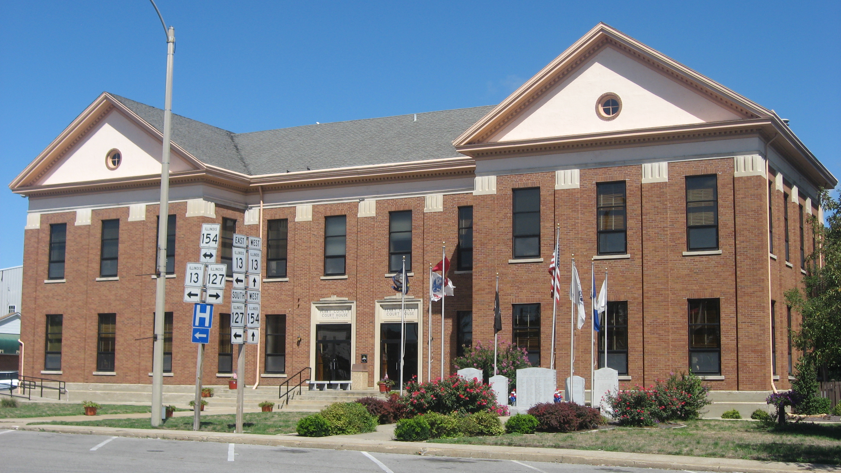
| Description |
English: Front and eastern side of the
Perry County Courthouse, located along Illinois Routes
13,
127, and
154 on Courthouse Square in
Pinckneyville,
Illinois,
United States. It was built in 1850 and massively expanded in 1879 and 1939. |
||
| Date | Taken on 8 September 2012 | ||
| Source | Own work | ||
| Author | Nyttend | ||
| Permission ( Reusing this file) |
|
File history
Click on a date/time to view the file as it appeared at that time.
| Date/Time | Thumbnail | Dimensions | User | Comment | |
|---|---|---|---|---|---|
| current | 22:26, 13 September 2012 |
| 2,816 × 1,584 (2.2 MB) | Nyttend | {{Location|38|4|50|N|89|23|0|W}} {{Information |Description={{en|Front and eastern side of the {{w|Perry County Courthouse (Illinois)|Perry County Courthouse}}, located along Illinois Routes {{w|Illinois Route 13|13}}, {{w|Illinois Route 127|127}}, and... |
File usage
The following pages on the English Wikipedia use this file (pages on other projects are not listed):
Global file usage
The following other wikis use this file:
- Usage on ar.wikipedia.org
- Usage on azb.wikipedia.org
- Usage on ca.wikipedia.org
- Usage on ceb.wikipedia.org
- Usage on ce.wikipedia.org
- Usage on cy.wikipedia.org
- Usage on de.wikipedia.org
- Usage on es.wikipedia.org
- Usage on eu.wikipedia.org
- Usage on fa.wikipedia.org
- Usage on fr.wikipedia.org
- Usage on ht.wikipedia.org
- Usage on hu.wikipedia.org
- Usage on hy.wikipedia.org
- Usage on it.wikipedia.org
- Usage on ja.wikipedia.org
- Usage on ko.wikipedia.org
- Usage on lld.wikipedia.org
- Usage on nl.wikipedia.org
- Usage on no.wikipedia.org
- Usage on pl.wikipedia.org
- Usage on pt.wikipedia.org
- Usage on ro.wikipedia.org
- Usage on ru.wikipedia.org
- Usage on sr.wikipedia.org
- Usage on sv.wikipedia.org
- Usage on tr.wikipedia.org
- Usage on tt.wikipedia.org
- Usage on uk.wikipedia.org
- Usage on ur.wikipedia.org
- Usage on uz.wikipedia.org
- Usage on vi.wikipedia.org
- Usage on vo.wikipedia.org
- Usage on www.wikidata.org
- Usage on zh-min-nan.wikipedia.org
View more global usage of this file.
Metadata
Size of this preview:
800 × 450 pixels. Other resolutions:
320 × 180 pixels |
640 × 360 pixels |
1,024 × 576 pixels |
1,280 × 720 pixels |
2,816 × 1,584 pixels.
Original file (2,816 × 1,584 pixels, file size: 2.2 MB, MIME type: image/jpeg)
| This is a file from the
Wikimedia Commons. Information from its
description page there is shown below. Commons is a freely licensed media file repository. You can help. |
| Camera location |
| View this and other nearby images on: OpenStreetMap |
|
|---|
| Description |
English: Front and eastern side of the
Perry County Courthouse, located along Illinois Routes
13,
127, and
154 on Courthouse Square in
Pinckneyville,
Illinois,
United States. It was built in 1850 and massively expanded in 1879 and 1939. |
||
| Date | Taken on 8 September 2012 | ||
| Source | Own work | ||
| Author | Nyttend | ||
| Permission ( Reusing this file) |
|
File history
Click on a date/time to view the file as it appeared at that time.
| Date/Time | Thumbnail | Dimensions | User | Comment | |
|---|---|---|---|---|---|
| current | 22:26, 13 September 2012 |
| 2,816 × 1,584 (2.2 MB) | Nyttend | {{Location|38|4|50|N|89|23|0|W}} {{Information |Description={{en|Front and eastern side of the {{w|Perry County Courthouse (Illinois)|Perry County Courthouse}}, located along Illinois Routes {{w|Illinois Route 13|13}}, {{w|Illinois Route 127|127}}, and... |
File usage
The following pages on the English Wikipedia use this file (pages on other projects are not listed):
Global file usage
The following other wikis use this file:
- Usage on ar.wikipedia.org
- Usage on azb.wikipedia.org
- Usage on ca.wikipedia.org
- Usage on ceb.wikipedia.org
- Usage on ce.wikipedia.org
- Usage on cy.wikipedia.org
- Usage on de.wikipedia.org
- Usage on es.wikipedia.org
- Usage on eu.wikipedia.org
- Usage on fa.wikipedia.org
- Usage on fr.wikipedia.org
- Usage on ht.wikipedia.org
- Usage on hu.wikipedia.org
- Usage on hy.wikipedia.org
- Usage on it.wikipedia.org
- Usage on ja.wikipedia.org
- Usage on ko.wikipedia.org
- Usage on lld.wikipedia.org
- Usage on nl.wikipedia.org
- Usage on no.wikipedia.org
- Usage on pl.wikipedia.org
- Usage on pt.wikipedia.org
- Usage on ro.wikipedia.org
- Usage on ru.wikipedia.org
- Usage on sr.wikipedia.org
- Usage on sv.wikipedia.org
- Usage on tr.wikipedia.org
- Usage on tt.wikipedia.org
- Usage on uk.wikipedia.org
- Usage on ur.wikipedia.org
- Usage on uz.wikipedia.org
- Usage on vi.wikipedia.org
- Usage on vo.wikipedia.org
- Usage on www.wikidata.org
- Usage on zh-min-nan.wikipedia.org
View more global usage of this file.