Peramangkland.png (404 × 439 pixels, file size: 56 KB, MIME type: image/png)
| Description |
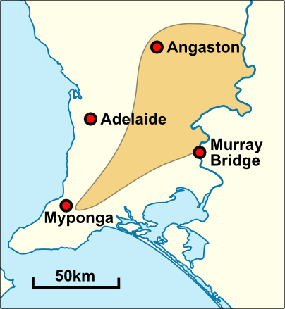
Approximate extent of the traditional territory of the Peramangk people. Based on the description by Norman B. Tindale (1940). Map based on File:Australia South Australia location map.svg. |
|---|---|
| Source |
I ( Yeti Hunter ( talk)) created this work entirely by myself. |
| Date |
07:20, 15 January 2010 (UTC) |
| Author |
Yeti Hunter ( talk) |
| Permission ( Reusing this file) |
See below.
|
Licensing
|
| This work is licensed under the Creative Commons Attribution-ShareAlike 3.0 License. |
 | Permission is granted to copy, distribute and/or modify this document under the terms of the GNU Free Documentation License, Version 1.2 or any later version published by the Free Software Foundation; with no Invariant Sections, no Front-Cover Texts, and no Back-Cover Texts. |
 | This file is a candidate to be copied to
Wikimedia Commons.
Any user may perform this transfer; refer to Wikipedia:Moving files to Commons for details. If this file has problems with attribution, copyright, or is otherwise ineligible for Commons, then remove this tag and DO NOT transfer it; repeat violators may be blocked from editing. Other Instructions
| ||
| |||
File history
Click on a date/time to view the file as it appeared at that time.
| Date/Time | Thumbnail | Dimensions | User | Comment | |
|---|---|---|---|---|---|
| current | 11:32, 8 April 2010 |
| 404 × 439 (56 KB) | Yeti Hunter ( talk | contribs) | Corrected Eastern boundary. |
| 07:20, 15 January 2010 |
 | 289 × 289 (35 KB) | Yeti Hunter ( talk | contribs) | {{Information |Description = Approximate extent of the traditional territory of the Peramangk people. Based on the description by Norman B. Tindale (1940). Map based on File:Australia South Australia location map.svg. |Source = I (~~~) c |
You cannot overwrite this file.
File usage
Peramangkland.png (404 × 439 pixels, file size: 56 KB, MIME type: image/png)
| Description |
Approximate extent of the traditional territory of the Peramangk people. Based on the description by Norman B. Tindale (1940). Map based on File:Australia South Australia location map.svg. |
|---|---|
| Source |
I ( Yeti Hunter ( talk)) created this work entirely by myself. |
| Date |
07:20, 15 January 2010 (UTC) |
| Author |
Yeti Hunter ( talk) |
| Permission ( Reusing this file) |
See below.
|
Licensing
|
| This work is licensed under the Creative Commons Attribution-ShareAlike 3.0 License. |
|
| Permission is granted to copy, distribute and/or modify this document under the terms of the GNU Free Documentation License, Version 1.2 or any later version published by the Free Software Foundation; with no Invariant Sections, no Front-Cover Texts, and no Back-Cover Texts. |
|
| This file is a candidate to be copied to
Wikimedia Commons.
Any user may perform this transfer; refer to Wikipedia:Moving files to Commons for details. If this file has problems with attribution, copyright, or is otherwise ineligible for Commons, then remove this tag and DO NOT transfer it; repeat violators may be blocked from editing. Other Instructions
| ||
| |||
File history
Click on a date/time to view the file as it appeared at that time.
| Date/Time | Thumbnail | Dimensions | User | Comment | |
|---|---|---|---|---|---|
| current | 11:32, 8 April 2010 |
| 404 × 439 (56 KB) | Yeti Hunter ( talk | contribs) | Corrected Eastern boundary. |
| 07:20, 15 January 2010 |
| 289 × 289 (35 KB) | Yeti Hunter ( talk | contribs) | {{Information |Description = Approximate extent of the traditional territory of the Peramangk people. Based on the description by Norman B. Tindale (1940). Map based on File:Australia South Australia location map.svg. |Source = I (~~~) c |
You cannot overwrite this file.